world.wikisort.org - Australia
Moorak is a locality in the Australian state of South Australia located in the state's Limestone Coast region.[2]
| Moorak South Australia | |||||||||||||||
|---|---|---|---|---|---|---|---|---|---|---|---|---|---|---|---|
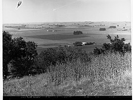
 Moorak from the road around Blue Lake, ca 1932 | |||||||||||||||
 Moorak | |||||||||||||||
| Coordinates | 37.8635°S 140.7382°E | ||||||||||||||
| Population | 1,226 (2016 census)[1] | ||||||||||||||
| Established | 1999[2] | ||||||||||||||
| Postcode(s) | 5291 | ||||||||||||||
| LGA(s) | District Council of Grant[2] | ||||||||||||||
| Region | Limestone Coast[3] | ||||||||||||||
| County | Grey[2] | ||||||||||||||
| State electorate(s) | Mount Gambier[4] | ||||||||||||||
| Federal division(s) | Barker[5] | ||||||||||||||
| |||||||||||||||
| |||||||||||||||
| Footnotes | Adjoining localities[2] | ||||||||||||||
The name Moorak may be a native word for "Mountain", but not from the local tribe, according to Doctor Browne who was an early landowner.[7]
The 2016 Australian census which was conducted in August 2016 reports that Moorak had a population of 1226 people.[1]
Moorak is located within the federal division of Barker, the state electoral district of Mount Gambier and the local government area of the District Council of Grant.[5][4][2]
See also
- Kilsby sinkhole
References
- Australian Bureau of Statistics (27 June 2017). "Moorak". 2016 Census QuickStats. Retrieved 22 April 2018.
- "Search result for "Moorak (Locality Bounded)" (Record no SA0046076) with the following layers selected – "Suburbs and Localities", "Place names (gazetteer)" and "Development Plan Layers"". Property Location Browser. Government of South Australia. Archived from the original on 12 October 2016. Retrieved 22 August 2016.
- "Limestone Coast SA Government region" (PDF). The Government of South Australia. Retrieved 10 October 2014.
- "District of Mount Gambier Background Profile". Electoral Commission SA. Retrieved 28 March 2016.
- "Federal electoral division of Barker" (PDF). Australian Electoral Commission. Retrieved 28 March 2016.
- "Monthly climate statistics: Summary statistics Mount Gambier Aero (nearest weather station)". Commonwealth of Australia , Bureau of Meteorology. Retrieved 17 August 2016.
- "Placename Details: Moorak". Property Location Browser. Department of Planning, Transport and Infrastructure. 5 February 2008. SA0046076. Archived from the original on 12 October 2016. Retrieved 31 August 2015. vide "History of the South East" page 124 by H.C.Talbot
Текст в блоке "Читать" взят с сайта "Википедия" и доступен по лицензии Creative Commons Attribution-ShareAlike; в отдельных случаях могут действовать дополнительные условия.
Другой контент может иметь иную лицензию. Перед использованием материалов сайта WikiSort.org внимательно изучите правила лицензирования конкретных элементов наполнения сайта.
Другой контент может иметь иную лицензию. Перед использованием материалов сайта WikiSort.org внимательно изучите правила лицензирования конкретных элементов наполнения сайта.
2019-2025
WikiSort.org - проект по пересортировке и дополнению контента Википедии
WikiSort.org - проект по пересортировке и дополнению контента Википедии