world.wikisort.org - Australia
Gurley is a small town in the northwest of New South Wales, Australia between Narrabri and Moree. The Newell Highway and the North-West railway line pass through the township. A now-closed railway station opened in 1897.[2]
| Gurley New South Wales | |
|---|---|
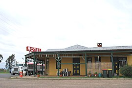
 Royal Hotel at Gurley | |
 Gurley | |
| Coordinates | 29°44′S 149°48′E |
| Population | 236 (2016 census)[1] |
| Postcode(s) | 2398 |
| Location |
|
| LGA(s) | Moree Plains Shire |
| State electorate(s) | Northern Tablelands |
| Federal division(s) | Parkes |
Gurley Siding Post Office opened on 16 March 1898 and was renamed Gurley in 1917.[3]
Gurley railway station
| Preceding station | Former Services | Following station | ||
|---|---|---|---|---|
| Moree towards Mungindi |
Mungindi Line | Bellata towards Werris Creek | ||
References
- Australian Bureau of Statistics (27 June 2017). "Gurley (State Suburb)". 2016 Census QuickStats. Retrieved 21 March 2018.
- Gurley station. NSWrail.net, accessed 3 September 2009.
- Phoenix Auctions History. "Post Office List". Phoenix Auctions. Retrieved 19 March 2021.
Текст в блоке "Читать" взят с сайта "Википедия" и доступен по лицензии Creative Commons Attribution-ShareAlike; в отдельных случаях могут действовать дополнительные условия.
Другой контент может иметь иную лицензию. Перед использованием материалов сайта WikiSort.org внимательно изучите правила лицензирования конкретных элементов наполнения сайта.
Другой контент может иметь иную лицензию. Перед использованием материалов сайта WikiSort.org внимательно изучите правила лицензирования конкретных элементов наполнения сайта.
2019-2025
WikiSort.org - проект по пересортировке и дополнению контента Википедии
WikiSort.org - проект по пересортировке и дополнению контента Википедии