world.wikisort.org - Australia
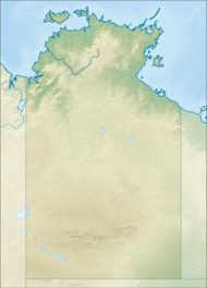
Garig Gunak Barlu is a protected area in the Northern Territory of Australia on the Cobourg Peninsula and some adjoining waters about 216 kilometres (134 mi) north-east of the territory capital of Darwin.
| Garig Gunak Barlu National Park Northern Territory | |
|---|---|
IUCN category II (national park)[1] | |
 Garig Gunak Barlu National Park | |
| Nearest town or city | Jabiru |
| Coordinates | 11°19′16″S 132°10′42″E |
| Established | 2000 |
| Area | 2,260.06 km2 (872.6 sq mi)[1] |
| Managing authorities |
|
| Website | Garig Gunak Barlu National Park |
| Footnotes | |
Ramsar Wetland | |
| Official name | Cobourg Peninsula |
| Designated | 30 March 1992 |
| Reference no. | 545[2] |
| See also | Protected areas of the Northern Territory |
It was established by joining the former Gurig National Park and the Cobourg Marine Park. Its name derives from the local Garig language, and the words gunak 'land' and barlu 'deep water'.[3]
The national park consists of all land of the Cobourg Peninsula, of Burford Island, the Sir George Hope Islands (from west to east Greenhill, Wangoindjung, Warldagawaji, Morse, Wunmiyi), Mogogout Island and Endyalgout Island (117.4 km2) to the south of the peninsula, and of adjacent waters. Croker Island, although close east of the peninsula, is not part of the park.
It is categorized as an IUCN Category II protected area.[1]
See also
- Protected areas of the Northern Territory
References
- "CAPAD 2012 Northern Territory Summary (see 'DETAIL' tab)". CAPAD 2012. Australian Government - Department of the Environment. 7 February 2014. Retrieved 7 February 2014.
- "Cobourg Peninsula". Ramsar Sites Information Service. Retrieved 25 April 2018.
- "Official fact sheet and map" (PDF). Archived from the original (PDF) on 27 March 2014.
External links
| Authority control: National libraries |
|---|
This Northern Territory geography article is a stub. You can help Wikipedia by expanding it. |
This Australian protected areas-related article is a stub. You can help Wikipedia by expanding it. |
Другой контент может иметь иную лицензию. Перед использованием материалов сайта WikiSort.org внимательно изучите правила лицензирования конкретных элементов наполнения сайта.
WikiSort.org - проект по пересортировке и дополнению контента Википедии