world.wikisort.org - Australia
Daly Waters is a town and locality in the Northern Territory of Australia located about 620 kilometres (390 mi) south of the territory capital of Darwin at the intersection of the Carpentaria Highway and the Stuart Highway.[7]
| Daly Waters Northern Territory | |||||||||||||||
|---|---|---|---|---|---|---|---|---|---|---|---|---|---|---|---|
 The front of the famous Daly Waters Pub | |||||||||||||||
Daly Waters | |||||||||||||||
| Coordinates | 16°15′44″S 133°22′45″E[1] | ||||||||||||||
| Population | 9 (2016 census)[2] | ||||||||||||||
| Established | 1927 (town) 4 April 2007 (locality)[3][1] | ||||||||||||||
| Elevation | 212 m (696 ft)[4] | ||||||||||||||
| Time zone | ACST (UTC+9:30) | ||||||||||||||
| Location |
| ||||||||||||||
| LGA(s) | Roper Gulf Region[1] | ||||||||||||||
| |||||||||||||||
| Footnotes | Adjoining localities[5][6] | ||||||||||||||
The area's traditional owners, the Jingili people, believe the Dreaming tracks of the Emu and the Sun travelled through here on their way to the southern parts of the Northern Territory.[citation needed]
History
The name Daly Waters was given to a series of natural springs by John McDouall Stuart during his third attempt to cross Australia from south to north, in 1861–62.[8] Stuart named the springs after the new Governor of South Australia, Sir Dominick Daly.[9]
Stuart's first attempt, in 1860, had reached Tennant Creek. The second, in early 1861, pushed further north but again Stuart turned back. The third journey left Adelaide in October 1861 and reached Daly Waters on 28 May. The party had been pushing through difficult lancewood scrub and harsh terrain at a little over a kilometre a day. This journey was successful, reaching the north coast near modern Darwin on 24 July 1862. Stuart's Tree has an 'S' carved into it by Stuart during his journey.[citation needed]
The Overland Telegraph Line reached Daly Waters from the north in June 1872 and for two months a 'pony express' carried messages the 421 km to Tennant Creek via Renner Springs.[citation needed]
Daly Waters Airfield was a centre for the London to Sydney air race of 1926, a refuelling stop for early Qantas flights to Singapore, a World War II Airforce base, including a field hospital, and more recently an operational base for joint military manoeuvres. Although the aerodrome was closed to commercial traffic in 1969,[10] the original Qantas hangar still stands, housing exhibits of photographs and equipment from the area's aviation past.[citation needed]
The traditional owners of the area became the fourth Indigenous group in the Northern Territory to gain native title over both the townsite and ten surrounding pastoral leases covering an area of 30,000 square kilometres (11,583 sq mi). The Federal Court of Australia had a special ceremonial sitting on nearby Newcastle Waters Station to commemorate the occasion.[11]
Trivia
The main attraction for tourists is the famous pub, which is decorated throughout with banknotes and other memorabilia left by visitors from every corner of the globe. The historic pub was licensed in 1938 to service passengers and crew from the nearby airfield.[citation needed]
Other services are available at the Hi-Way Inn roadhouse, at the junction of the Carpentaria Highway.[citation needed]
Gallery
 The Daly Waters "traffic light"
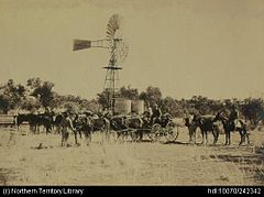 Government Bores, Overland Telegraph (OT) route. Water tanks, windmill, packing up camp onto the buggy.
 Daly Waters Telegraph Station


Climate
Daly Waters has a hot semi-arid climate (Köppen BSh) with two distinct seasons. There is a sweltering, humid and extremely uncomfortable wet season from November to March and a hot, generally rainless dry season from April to October. The wet season is highly erratic – for instance only 192.4 millimetres or 7.57 inches of rain fell between November 1899 and March 1900, but as much as 588.3 millimetres or 23.16 inches in January 1895 and 612.4 millimetres or 24.11 inches in January 2009.[12] In the wet season roads are frequently closed by heavy rainfall, which has exceeded 150 millimetres or 6 inches in a day from tropical rain depressions on several occasions, whilst heat discomfort is extreme as wet bulb temperatures average 24.6 °C or 76.3 °F on typical January and February afternoons. Temperatures actually peak just before the wet season begins in October and November at around 38 °C or 100.4 °F but discomfort is less extreme due to lower humidity. In the dry season, cloudless skies and comfortable morning temperatures make for much more pleasant conditions.
| Climate data for Daly Waters (opened 1873; latest observations published in 2013) | |||||||||||||
|---|---|---|---|---|---|---|---|---|---|---|---|---|---|
| Month | Jan | Feb | Mar | Apr | May | Jun | Jul | Aug | Sep | Oct | Nov | Dec | Year |
| Record high °C (°F) | 44.0 (111.2) |
42.0 (107.6) |
40.0 (104.0) |
38.7 (101.7) |
36.5 (97.7) |
35.3 (95.5) |
34.9 (94.8) |
37.5 (99.5) |
39.5 (103.1) |
41.7 (107.1) |
42.8 (109.0) |
43.5 (110.3) |
44.0 (111.2) |
| Average high °C (°F) | 36.6 (97.9) |
35.5 (95.9) |
34.6 (94.3) |
33.7 (92.7) |
31.4 (88.5) |
28.7 (83.7) |
28.9 (84.0) |
31.9 (89.4) |
35.0 (95.0) |
37.7 (99.9) |
38.4 (101.1) |
38.2 (100.8) |
34.2 (93.6) |
| Average low °C (°F) | 24.0 (75.2) |
23.4 (74.1) |
22.4 (72.3) |
19.3 (66.7) |
15.8 (60.4) |
12.9 (55.2) |
11.8 (53.2) |
13.5 (56.3) |
17.2 (63.0) |
21.1 (70.0) |
23.5 (74.3) |
24.0 (75.2) |
19.1 (66.4) |
| Record low °C (°F) | 15.6 (60.1) |
15.6 (60.1) |
14.0 (57.2) |
11.2 (52.2) |
5.0 (41.0) |
2.1 (35.8) |
2.0 (35.6) |
2.7 (36.9) |
5.2 (41.4) |
11.0 (51.8) |
14.9 (58.8) |
16.0 (60.8) |
2.0 (35.6) |
| Average rainfall mm (inches) | 166.5 (6.56) |
165.2 (6.50) |
117.7 (4.63) |
23.7 (0.93) |
5.0 (0.20) |
5.6 (0.22) |
1.5 (0.06) |
1.7 (0.07) |
4.9 (0.19) |
22.5 (0.89) |
58.1 (2.29) |
110.2 (4.34) |
677.5 (26.67) |
| Average rainy days (≥ 0.2 mm) | 12.2 | 12.0 | 8.3 | 2.5 | 0.6 | 0.5 | 0.3 | 0.2 | 0.7 | 2.8 | 6.1 | 9.9 | 56.1 |
| Source: [4] | |||||||||||||
References
- "Place Names Register Extract for Daly Waters (locality)". NT Place Names Register. Northern Territory Government. Retrieved 21 April 2019.
- Australian Bureau of Statistics (27 June 2017). "Daly Waters (State Suburb)". 2016 Census QuickStats. Retrieved 28 January 2018.
- "Place Names Register Extract for the Town of Daly Waters". NT Place Names Register. Northern Territory Government. Retrieved 21 April 2019.
- "Daly Waters". Climate statistics for Australian locations. Bureau of Meteorology. Retrieved 26 November 2011.
- "Daly Waters (locality)". NT Atlas and Spatial Data Directory. Northern Territory Government. Retrieved 21 April 2019.
- "Roper Gulf (map)" (PDF). Northern Territory Government. 29 October 1997. Archived from the original (PDF) on 18 March 2019. Retrieved 21 April 2019.
- Hema, Maps (2007). Australia Road and 4WD Atlas (Map). Eight Mile Plains Queensland: Hema Maps. p. 96. ISBN 978-1-86500-456-3.
- "Daly Waters". Sydney Morning Herald. Fairfax Media. 8 February 2004. Retrieved 1 May 2015.
- "The Journals of John McDouall Stuart". ebooks@Adelaide. Adelaide University. 1858–1862. Archived from the original on 7 September 2015. Retrieved 1 May 2015.
- "Spirits of Ansett". spiritsof ansett.com. Jim Haynes. Retrieved 30 May 2021.
- "Locals gather to celebrate Native Title ruling". Australian Broadcasting Corporation. 27 June 2012. Retrieved 5 January 2013.
- "Monthly Rainfall: Daly Waters (014618)". Bureau of Meteorology.
External links
На других языках
[de] Daly Waters
Daly Waters ist eine Siedlung im australischen Bundesstaat Northern Territory mit gerade mal 16 Einwohnern, die jedoch auf vielen Karten des Kontinents verzeichnet ist. Es liegt etwa 620 Kilometer südlich von Darwin, einige Kilometer westlich des Stuart Highways und somit in einer weitgehend unbesiedelten Gegend.- [en] Daly Waters, Northern Territory
Другой контент может иметь иную лицензию. Перед использованием материалов сайта WikiSort.org внимательно изучите правила лицензирования конкретных элементов наполнения сайта.
WikiSort.org - проект по пересортировке и дополнению контента Википедии