world.wikisort.org - Australia
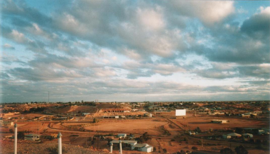
Coober Pedy (/ˈkuːbər ˈpiːdi/) is a town in northern South Australia, 846 km (526 mi) north of Adelaide on the Stuart Highway. The town is sometimes referred to as the "opal capital of the world" because of the quantity of precious opals that are mined there. Coober Pedy is renowned for its below-ground dwellings, called "dugouts", which are built in this fashion due to the scorching daytime heat.
| Coober Pedy Umoona South Australia | |||||||||||||||
|---|---|---|---|---|---|---|---|---|---|---|---|---|---|---|---|
 The town of Coober Pedy | |||||||||||||||
 Coober Pedy | |||||||||||||||
| Coordinates | 29°0′40″S 134°45′20″E | ||||||||||||||
| Population | 1,762 (2016 census)[1] | ||||||||||||||
| Established | 1915 | ||||||||||||||
| Postcode(s) | 5723 | ||||||||||||||
| Location |
| ||||||||||||||
| LGA(s) | District Council of Coober Pedy | ||||||||||||||
| Region | Far North[2] | ||||||||||||||
| State electorate(s) | Giles[3] | ||||||||||||||
| Federal division(s) | Grey[4] | ||||||||||||||
| |||||||||||||||
| |||||||||||||||
| Footnotes | Adjoining localities[5] | ||||||||||||||
The name "Coober Pedy" is thought to derive from the Aboriginal term kupa-piti, which means "whitefellas' hole", but in 1975 the local Aboriginal people of the town adopted the name Umoona, which means "long life" and is also their name for the mulga tree.
In the 2016 Australian census, there were 1,762 people in Coober Pedy.

History
Aboriginal peoples have a long-standing connection with the area.[6] Coober Pedy is considered by the senior Western Desert people to be the traditional lands of the Arabana people country, but Kokatha and Yankunytjatjara people are also closely attached to some ceremonial sites in the area. The origin of the name of the town (decided in 1920[7]) is thought to derive from the words in the Kokatha language, kupa piti, usually translated as "whitefella – hole in the ground", or guba bidi, "white man’s holes", relating to white people's mining activities[8] (also reported as meaning "boys' waterhole" in some sources[9]). Further investigation into the words by linguists shows that kupa may have originated from the Parnkalla language and that piti may be the Kokatha word specifically created for "quarry" (a white man's activity).[8]
The first European explorer to pass near the site of Coober Pedy was Scottish-born John McDouall Stuart in 1858. The town was not established until after 1915, when the first opal was discovered by Wille Hutchison on 1 February of that year.[6] Opal miners started moving in around 1916.[10] The name of Coober Pedy was decided upon at a meeting in 1920, when a post office was established.[7]
In July 1975 the local Aboriginal people of Coober Pedy adopted the name Umoona, which means "long life" and is also their name for the Acacia aneura, or mulga tree, which is plentiful in the area.[7] The name has since been used for various establishments in the town.
Description
Coober Pedy is a small town about halfway between Adelaide and Alice Springs. It is situated on the edge of the erosional scarp of the Stuart Ranges, on beds of sandstone and siltstone 30 metres (98 ft) deep and topped with a stony, treeless desert. Very little plant life exists in town due to the region's low rainfall, high cost of water, and lack of topsoil.[citation needed]

The harsh summer desert temperatures mean that many residents prefer to live in caves bored into the hillsides ("dugouts"). A standard three-bedroom cave home with lounge, kitchen, and bathroom can be excavated out of the rock in the hillside for a similar price to building a house on the surface. However, dugouts remain at a constant temperature, while surface buildings need air conditioning, especially during the summer months, when temperatures often exceed 40 °C (104 °F). The relative humidity rarely gets over 20% on these hot days, and the skies are usually cloud-free. The average maximum temperature is 30–32 °C (86–90 °F), but it can get quite cool in the winter.[citation needed]
The town's water supply, managed by the District Council which operates a bore and associated treatment plant, comes from the Great Artesian Basin. Problems with ageing pipes, high water losses, and lack of subsidies contribute to consumer water charges being the highest in South Australia.[11]
Mining
Opals
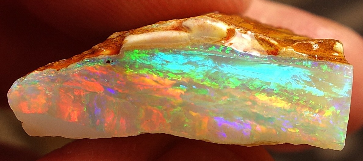
By 1999, there were more than 250,000 mine shaft entrances in the area and a law discouraged large-scale mining by allowing each prospector a 165-square-foot (15.3 m2) claim.[10] Coober Pedy supplies most of the world's gem-quality opal; it has over 70 opal fields and is the largest opal mining area in the world.[citation needed]
Other minerals

In May 2009, South Australian Premier Mike Rann opened the $1.15 billion Prominent Hill Mine, 130 kilometres (81 mi) south east of Coober Pedy. The copper-gold mine is operated by OZ Minerals.[12]
In August 2010 Rann opened the Cairn Hill iron ore/copper/gold mine operated by IMX Resources near Coober Pedy. It was the first new iron ore mining area opened in South Australia since the 19th century.[13] Due to low iron ore prices, the Cairn Hill mine was closed in June 2014.[14] It was sold to Cu-River Mining who reopened the mine in 2016.[15]
Oil reserves
In 2013, a potentially significant tight oil (oil trapped in oil-bearing shales) resource was found near the outskirts of Coober Pedy in the Arckaringa Basin.[16] This resource was estimated to hold between 3.5 and 223 billion barrels (560×106 and 35,450×106 m3) of oil, providing the potential for Australia to become a net oil exporter.[17][18]
Tourism
The town has become a popular stopover point and tourist destination, especially since 1987, when the sealing of the Stuart Highway was completed.[citation needed]


Coober Pedy today relies as much on tourism as the opal mining industry to provide the community with employment and sustainability.[citation needed] Visitors' attractions in Coober Pedy include the mines, the graveyard and the underground churches (the Serbian Orthodox Church and the Catholic Church).[19] There are several motels offering underground accommodation, ranging from a few rooms to the entire motel being a dug-out.[20] The hybrid Coober Pedy Solar Power Station supplies power to the off-grid area.[21]
The Umoona Opal Mine and Museum is a popular attraction.[22]
Heritage sites
Coober Pedy has a number of heritage-listed sites, including:
- 13 Hutchison Street: Three-Roomed Dugout[23]
- 9 Hutchison Street: Coober Pedy Catholic Church and Presbytery[24]
Amenities and services
The Umoona Tjutagku Health Service Aboriginal Corporation (UTHSAC) was established in 2005 to provide health services for local Aboriginal people.[25]
Local media
Coober Pedy is home to the Coober Pedy Regional Times, a free community publication released fortnightly since 15 March 2001.[26] Under a previous name, it had begun as a newsletter called the Coober Pedy Times, which was first issued in August 1982,[27] itself continuing from a publication known as "Opal Chips".[28] After some financial difficulties, the Times was bought by its editor, Margaret McKay,[29] in 2006 and now includes online versions.[28]
Sport and recreation
The local golf course – mostly played at night with glowing balls, to avoid daytime heat – is completely free of grass, and golfers take a small piece of "turf" around to use for teeing off. As a result of correspondence between the two clubs, the Coober Pedy golf club is the only club in the world to enjoy reciprocal rights at The Royal and Ancient Golf Club of St Andrews.[30]
The town also has an Australian rules football club, the Coober Pedy Saints, established in 2004, which competes in the Far North Football League (formerly the Woomera & Districts Football League). Due to the town's isolation, to play matches the Saints must make round trips of over 900 kilometres (560 mi) to Roxby Downs, where the rest of the league's teams are located.
The town has a drive-in theatre. It opened in 1965, but became less popular after 1980 with the arrival of television to the town, and ceased regular operation in 1984. It was re-opened in 1996.[31][32]
Art centre
A board for the Umoona Community Art Centre was established in 2021, but needs government funding to establish a permanent location in the town. A group of highly talented artists has joined the APY Art Centre Collective, which helps to create employment opportunities for Indigenous artists in the region. An exhibition in the Adelaide gallery of the collective in September 2021 featured the work of 24 of these artists.[33]
In philately
A rare exhibition cachet, signed by Coober Pedy postmaster Alfred P. North, was discovered in Memphis, Tennessee by philatelist David Saks on 3 February 2016. To date, it is the only known example of this cachet in the world.[34][35]
In popular culture

Both the town and its hinterland, for different reasons, are photogenic and have attracted film makers. The town itself was the setting for:[36][37]
- Fire in the Stone (1984)
- Until the End of the World (1991)
- Opal Dream (2006)
Its environment has also attracted movie producers, with parts of these movies filmed in the area:[38]
- Mad Max Beyond Thunderdome (1985)
- Ground Zero (1987)
- The Blood of Heroes (1989)
- The Adventures of Priscilla, Queen of the Desert (1994)
- Pitch Black (2000)
- Red Planet (2000)
- Kangaroo Jack (2003)
- The Osiris Child: Science Fiction Volume One (2016)
- Instant Hotel Season 2 (2018)[39]
- Mortal Kombat (2021)
The town is featured in the 2016 racing game Forza Horizon 3 and is the location of the Horizon Outback Festival.
Climate
Coober Pedy experiences a hot desert climate (Köppen: BWh, Trewartha: BWhl), with very hot, dry summers; mild to hot, dry springs and autumns; and mild, dry winters. Typical of a desert climate, diurnal ranges are wider than in most places, with an annual average high of 27.8 °C (82.0 °F) and an annual average low of just 14.2 °C (57.6 °F). Summer temperatures range from 35 °C (95 °F) in the shade, with occasional dust storms. The annual rainfall in the area is low and amongst the lowest in Australia, at around 141 millimetres (5.6 in).[40][41] Precipitation is well-distributed through the year, although the lowest amounts are recorded in the winter months.
Extremes of annual rainfall since 1921 range from 30.6 millimetres (1.20 in) in 1929 to 427.2 millimetres (16.82 in) in 1973.[42]
Coober Pedy was flooded when 115 millimetres (4.5 in) of rainfall was recorded in 24 hours (which is over three-quarters of the mean annual rainfall) on 10 April 2014.[43]
| Climate data for Coober Pedy Airport, South Australia, Australia (1994-present normals and extremes); 225 m AMSL | |||||||||||||
|---|---|---|---|---|---|---|---|---|---|---|---|---|---|
| Month | Jan | Feb | Mar | Apr | May | Jun | Jul | Aug | Sep | Oct | Nov | Dec | Year |
| Record high °C (°F) | 47.8 (118.0) |
47.0 (116.6) |
43.9 (111.0) |
41.5 (106.7) |
33.5 (92.3) |
32.1 (89.8) |
30.4 (86.7) |
34.3 (93.7) |
39.4 (102.9) |
44.8 (112.6) |
45.9 (114.6) |
48.3 (118.9) |
48.3 (118.9) |
| Mean maximum °C (°F) | 42.6 (108.7) |
41.2 (106.2) |
38.3 (100.9) |
33.2 (91.8) |
27.6 (81.7) |
22.2 (72.0) |
23.8 (74.8) |
26.6 (79.9) |
33.1 (91.6) |
36.8 (98.2) |
39.4 (102.9) |
40.8 (105.4) |
42.6 (108.7) |
| Average high °C (°F) | 36.7 (98.1) |
35.4 (95.7) |
32.0 (89.6) |
27.3 (81.1) |
22.1 (71.8) |
18.3 (64.9) |
18.7 (65.7) |
21.1 (70.0) |
25.7 (78.3) |
29.0 (84.2) |
32.2 (90.0) |
34.7 (94.5) |
27.8 (82.0) |
| Daily mean °C (°F) | 29.5 (85.1) |
28.4 (83.1) |
25.3 (77.5) |
20.9 (69.6) |
16.1 (61.0) |
12.6 (54.7) |
12.5 (54.5) |
14.4 (57.9) |
18.5 (65.3) |
21.6 (70.9) |
24.9 (76.8) |
27.4 (81.3) |
21.0 (69.8) |
| Average low °C (°F) | 22.2 (72.0) |
21.4 (70.5) |
18.5 (65.3) |
14.5 (58.1) |
10.0 (50.0) |
6.8 (44.2) |
6.4 (43.5) |
7.6 (45.7) |
11.2 (52.2) |
14.2 (57.6) |
17.6 (63.7) |
20.1 (68.2) |
14.2 (57.6) |
| Mean minimum °C (°F) | 16.7 (62.1) |
16.0 (60.8) |
13.6 (56.5) |
10.0 (50.0) |
6.2 (43.2) |
3.3 (37.9) |
3.0 (37.4) |
3.8 (38.8) |
6.8 (44.2) |
9.3 (48.7) |
12.5 (54.5) |
14.8 (58.6) |
3.0 (37.4) |
| Record low °C (°F) | 12.0 (53.6) |
12.0 (53.6) |
9.2 (48.6) |
5.2 (41.4) |
2.0 (35.6) |
−0.1 (31.8) |
−0.4 (31.3) |
0.9 (33.6) |
2.9 (37.2) |
5.5 (41.9) |
7.1 (44.8) |
10.1 (50.2) |
−0.4 (31.3) |
| Average precipitation mm (inches) | 14.2 (0.56) |
15.1 (0.59) |
10.7 (0.42) |
13.4 (0.53) |
10.0 (0.39) |
12.1 (0.48) |
4.8 (0.19) |
7.0 (0.28) |
8.6 (0.34) |
11.2 (0.44) |
15.1 (0.59) |
18.8 (0.74) |
141 (5.55) |
| Average precipitation days (≥ 1.0 mm) | 1.8 | 1.6 | 1.4 | 1.7 | 1.7 | 1.8 | 1.1 | 1.3 | 1.4 | 2.1 | 2.8 | 2.8 | 21.5 |
| Average relative humidity (%) | 28.0 | 31.5 | 33.0 | 36.0 | 45.5 | 54.5 | 51.0 | 42.5 | 35.0 | 31.0 | 31.0 | 29.5 | 37.4 |
| Average dew point °C (°F) | 6.1 (43.0) |
7.3 (45.1) |
5.1 (41.2) |
4.5 (40.1) |
4.6 (40.3) |
4.0 (39.2) |
2.6 (36.7) |
1.4 (34.5) |
1.7 (35.1) |
1.8 (35.2) |
3.6 (38.5) |
4.9 (40.8) |
4.0 (39.1) |
| Source: Australian Bureau of Meteorology (1994-present normals and extremes)[44] | |||||||||||||
Transport

The town is served by daily coach services from Adelaide by Greyhound Australia. The Ghan train serves the town through the Manguri Siding, 42 kilometres (26 mi) from Coober Pedy, which is served by trains once weekly in each direction. Passengers on The Ghan are not usually allowed to disembark at Manguri unless they have prearranged transport, due to the siding's isolation and the extremely cold temperatures at night.[45]
Coober Pedy is a gateway to the outback communities of Oodnadatta and William Creek, which are both located on the Oodnadatta Track. There is a twice-a-week mail run from Coober Pedy to these communities and other outback homesteads. It carries the mail, general freight and passengers.[46]
Regional Express also has direct flights to Adelaide, from Coober Pedy Airport.
| Preceding station | Journey Beyond | Following station | ||
|---|---|---|---|---|
| Alice Springs One-way operation |
The Ghan towards Adelaide only |
Adelaide Terminus | ||
See also
- Kupa Piti Kungka Tjuta
References
- Australian Bureau of Statistics (27 June 2017). "Coober Pedy (State Suburb)". 2016 Census QuickStats. Retrieved 28 January 2018.
- "Far North SA government region" (PDF). The Government of South Australia. Retrieved 16 August 2015.
- "District of Giles Background Profile". Electoral Commission SA. Retrieved 20 August 2015.
- "Federal electoral division of Grey, boundary gazetted 16 December 2011" (PDF). Australian Electoral Commission. Retrieved 20 August 2015.
- "Search result for "Coober Pedy (LOCB)" (Record no SA0015214) with the following layers selected - "Suburbs and Localities", "Place names (gazetteer)" and "Road Labels"". Property Location Browser. Government of South Australia. Archived from the original on 12 October 2016. Retrieved 2 February 2017.
- Henderson Henderson. "District Council of Coober Pedy - Welcome to the Opal Capital of the World". Archived from the original on 22 July 2012. Retrieved 29 September 2007.
- "The History of Coober Pedy". Coober Pedy SA. Retrieved 13 October 2021.
- Naessan, Petter (2010). "The etymology of Coober Pedy, South Australia". Aboriginal History. 34: 217–233. JSTOR 24047032. PDF
- Place Names of South Australia Archived 28 July 2012 at the Wayback Machine
- Smith, R. Australia: Journey Through a Timeless Land. National Geographic Society, 1999. p 118.
- Opal capital Coober Pedy 'on knife-edge' as desert town faces big water problem ABC News, 6 March 2019. Retrieved 29 October 2020.
- Christopher Russell (25 May 2009). "Prominent Hill open for business". The Advertiser. Retrieved 9 September 2014.
- "IMX Celebrates Opening of SA's First Iron Ore Mining District Since 19th Century" (PDF) (Press release). IMX Resources. 26 August 2010. Archived from the original (PDF) on 19 February 2011. Retrieved 9 September 2014.
- Cairn Hill iron ore miner IMX Resources to close South Australian office, focus on Tanzanian exploration The Advertiser, 3 September 2014. Accessed 4 September 2014.
- "Overview". Cu-River Mining. Retrieved 24 September 2019.
- "Major oil discovery in outback SA". Yahoo7 Finance Australia. 24 January 2013.
- England, Cameron (24 January 2013). "$20 trillion shale oil find surrounding Coober Pedy 'can fuel Australia'". Herald Sun. Retrieved 23 January 2013.
- "$20 trillion shale oil find surrounding Coober Pedy 'can fuel Australia'". NewsComAu.
- "Coober Pedy Attractions" (PDF). Coober Pedy Visitors Information Center. Retrieved 23 July 2015.
- "Experience Underground". www.cooberpedy.net. Archived from the original on 7 June 2017. Retrieved 14 June 2017.
- "EDL's Coober Pedy Hybrid Renewable Project wins at 2019 Asia Power Awards". RenewEconomy. 5 September 2019.
- "Umoona Opal Mine And Museum". South Australia. Government of South Australia. Retrieved 13 October 2021.
- "Three-roomed dugout, including the ground within two metres of the dugout space". South Australian Heritage Register. Department of Environment, Water and Natural Resources. Archived from the original on 22 February 2016. Retrieved 15 February 2016.
- "Coober Pedy Catholic Church & Presbytery". South Australian Heritage Register. Department of Environment, Water and Natural Resources. Archived from the original on 22 February 2016. Retrieved 15 February 2016.
- "Hohme". Umoona Tjutagku Health Service. Retrieved 13 October 2021.
- Coober Pedy regional times [newspaper: microform]. Coober Pedy, S. Aust: Coober Pedy Regional Times. 2001.
- "Coober Pedy times". Retrieved 17 August 2018.
- "Coober Pedy Regional Times". Coober Pedy Regional Times. Retrieved 17 August 2018.
- Laube, Anthony. "LibGuides: SA Newspapers: Far North". guides.slsa.sa.gov.au. Retrieved 17 August 2018.
- Lane, James M. (2008). Moon Living Abroad in Australia. Berkeley, CA: Seal Press. p. 247. ISBN 978-1-59880-139-2.
- "History of the Coober Pedy Drive-in". Retrieved 7 April 2019.
- Patrick Martin (7 April 2019). "Coober Pedy's desert drive-in cinema a feast for the eyes — and not just on-screen". Australian Broadcasting Corporation. Retrieved 7 April 2019.
- Roberts, Georgia (9 October 2021). "Umoona Art Centre plan to fill 'major gap' and create opportunities in Coober Pedy -". ABC News. Australian Broadcasting Corporation. Retrieved 13 October 2021.
- "Jennifer Davison - The Royal Coober Pedy Historical Society". Retrieved 14 February 2016.
- Owens, David. "Connecting Wynne to the World". Wynne Progress. Retrieved 21 March 2016.
- Gluckman, Ron. "Home Under the Range". Ron Gluckman in Cyberspace. Retrieved 21 December 2008.
- "Coober Pedy". RockWalk Park. Archived from the original on 28 July 2005. Retrieved 21 December 2008.
- Leonard, Richard. "Science Fiction Volume One: The Osiris Child - Catholic Church in Australia". www.catholic.org.au. Retrieved 29 September 2017.
- Razz and Mark's 'Instant Hotel' Is Like Staying at the Flintstones' Distractify 20 April 2020
- Coober Pedy Visitor Information Centre > Climate Accessed 13 July 2014.
- CooberPedy.com.au > Coober Pedy weather Accessed 15 July 2014.
- "Coober Pedy". Climate statistics for Australian locations. Bureau of Meteorology. 29 April 2020. Retrieved 2 May 2020.
- "'Hopping mad' residents hit by outback flooding at Coober Pedy". Abc.net.au. 10 April 2014. Retrieved 13 June 2017.
- "Coober Pedy Airport, SA Climate (1994-present normals and extremes)". Australian Bureau of Meteorology. Retrieved 7 June 2022.
- "Q & A". Great Southern Railway. Archived from the original on 11 April 2010. Retrieved 1 February 2011.
- "The Mail Run Tour". Archived from the original on 3 May 2006.
External links
 Coober Pedy travel guide from Wikivoyage
- Official website (Coober Pedy Retail, Business & Tourism Association)
- Miller, Bob. (1994), "Five photographs", Coober Pedy, South Australia, 1994, National Library of Australia – via Trove
- Archived at Ghostarchive and the Wayback Machine: "Coober Pedy" (Video (3 minutes)), National Geographic, 27 November 2007
Authority control | |
|---|---|
| General |
|
| National libraries | |
На других языках
[de] Coober Pedy
Coober Pedy ist eine Ortschaft mit etwa 1700 Einwohnern in Südaustralien und liegt ca. 840 Kilometer nordwestlich von Adelaide am Stuart Highway. Sie ist Startpunkt des Anne Beadell Highway. Der Name „Coober Pedy“ ist die englische Schreibweise des Pitjandjari-Aborigine-Begriffs kupa piti, was so viel heißt wie „Loch des weißen Mannes“ (engl.: „white man‘s hole“).- [en] Coober Pedy
[ru] Кубер-Педи
Кубер-Педи (англ. Coober Pedy) — небольшой подземный город в центральной части австралийского штата Южная Австралия, центр одноимённого района местного самоуправления. Население города по оценкам на 2011 год составляло 1695 человек. Ближайшие крупные города — Порт-Огаста (500 километров к югу) и Алис-Спрингс (600 километров на север).Другой контент может иметь иную лицензию. Перед использованием материалов сайта WikiSort.org внимательно изучите правила лицензирования конкретных элементов наполнения сайта.
WikiSort.org - проект по пересортировке и дополнению контента Википедии