world.wikisort.org - Australia
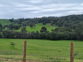
Burekup is a small town located on the South Western Highway in the South West region of Western Australia.
| Burekup Western Australia | |
|---|---|
 | |
 Burekup | |
 | |
| Coordinates | 33°19′0″S 115°48′0″E |
| Population | 788 (SAL 2021)[1] |
| Established | 1973 |
| Postcode(s) | 6227 |
| Elevation | 23 m (75 ft) |
| Location |
|
| LGA(s) | Shire of Dardanup |
| State electorate(s) | Collie-Preston |
| Federal division(s) | Forrest |
The town is built on the Collie River and was originally a railway siding on the Pinjarra-Picton line that was established in 1910 and known at the time as Boorekup. Following a request from the Shire of Dardanup, the town was gazetted in 1973.[2]
"Burekup" is the Indigenous Australian name for a wildflower that grows in the area.
References
- Australian Bureau of Statistics (28 June 2022). "Burekup (Suburb and Locality)". Australian Census 2021 QuickStats. Retrieved 28 June 2022.
- "History of country town names – B". Western Australian Land Information Authority. Retrieved 5 October 2008.
Текст в блоке "Читать" взят с сайта "Википедия" и доступен по лицензии Creative Commons Attribution-ShareAlike; в отдельных случаях могут действовать дополнительные условия.
Другой контент может иметь иную лицензию. Перед использованием материалов сайта WikiSort.org внимательно изучите правила лицензирования конкретных элементов наполнения сайта.
Другой контент может иметь иную лицензию. Перед использованием материалов сайта WikiSort.org внимательно изучите правила лицензирования конкретных элементов наполнения сайта.
2019-2025
WikiSort.org - проект по пересортировке и дополнению контента Википедии
WikiSort.org - проект по пересортировке и дополнению контента Википедии