world.wikisort.org - Australia
Archer River is a rural locality in the Shire of Cook, Queensland, Australia.[2] In the 2016 census Archer River had a population of 22 people.[1]
| Archer River Queensland | |||||||||||||||
|---|---|---|---|---|---|---|---|---|---|---|---|---|---|---|---|
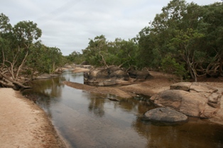 Archer River, 2011 | |||||||||||||||
 Archer River | |||||||||||||||
| Coordinates | 13.3527°S 142.6066°E | ||||||||||||||
| Population | 22 (2016 census)[1] | ||||||||||||||
| • Density | 0.00235/km2 (0.00607/sq mi) | ||||||||||||||
| Postcode(s) | 4871 | ||||||||||||||
| Area | 9,381.3 km2 (3,622.1 sq mi) | ||||||||||||||
| Time zone | AEST (UTC+10:00) | ||||||||||||||
| LGA(s) | Shire of Cook | ||||||||||||||
| State electorate(s) | Cook | ||||||||||||||
| Federal division(s) | Leichhardt | ||||||||||||||
| |||||||||||||||
Geography
This inland locality takes its name from the Archer River which flows from east to west across the locality towards the Gulf of Carpentaria. The Oyala Thumotang National Park (formerly known as Mungkan Kandju National Park and Archer Bend National Park) is in the south-west of the locality.[3]
The Peninsula Developmental Road passes through the locality in a NW-SE direction connecting Weipa on the Gulf of Carpentaria to Lakeland. There are two major road junctions within Archer River from the Peninsula Developmental Road. At 13.0804°S 142.7682°E there is a turn-off towards the north onto the Telegraph Road towards Bamaga at the northern tip of Cape York Peninsula. At 13.1733°S 142.8435°E there is a turn-off towards the north-east on Portland Road to the Lockhart River community on the Coral Sea coast.
History
Kaanju (also known as Kaanju and Kandju) is a language of Cape York. The Kaanju language region includes the landscape within the local government boundaries of the Cook Shire Council.[4]
Linngithigh (also known as Winda Winda and Linginiti) an Australian Aboriginal language spoken by the Linngithigh people. The Linngithigh language region includes landscape within the local government boundaries of the Cook Shire Council: Western Cape York, Winda Winda Creek, Mission River, and Archer River.[5]
In the 2016 census Archer River had a population of 22 people.[1]
Amenities
The Archer River Roadhouse (13.4379°S 142.9416°E) is located on the Peninsula Developmental Road immediately south of the Archer River. It provides accommodation, laundry, meals, fuel, minor motor vehicle repairs, and internet access.[6]
Heritage listings
Archer River has a number of heritage-listed sites, including:
- Wenlock Goldfield[7]
References
- Australian Bureau of Statistics (27 June 2017). "Archer River (SSC)". 2016 Census QuickStats. Retrieved 20 October 2018.
- "Archer River – locality in Shire of Cook (entry 46121)". Queensland Place Names. Queensland Government. Retrieved 27 December 2020.
- "Oyala Thumotang National Park". Queensland Government. Retrieved 3 June 2014.
-
 This Wikipedia article incorporates CC-BY-4.0 licensed text from: "Queensland Aboriginal and Torres Strait Islander languages map". State Library of Queensland. State Library of Queensland. Retrieved 30 January 2020.
- "Linngithigh". State Library of Queensland. Archived from the original on 23 April 2021. Retrieved 30 January 2020.
- "Archer River Roadhouse". Tourism Cape York. Archived from the original on 6 June 2014. Retrieved 3 June 2014.
- "Wenlock Goldfield (entry 601862)". Queensland Heritage Register. Queensland Heritage Council. Retrieved 7 July 2013.
На других языках
- [en] Archer River, Queensland
[ru] Арчер (населённый пункт)
Арчер-Ривер (англ. Archer River) — населённый пункт и территория в графстве Кук, штат Квинсленд, Австралия[1]. Население — 22 человека (2016 год)[2]. Своё название населённый пункт получил от протекающей в этом регионе реки Арчер.Другой контент может иметь иную лицензию. Перед использованием материалов сайта WikiSort.org внимательно изучите правила лицензирования конкретных элементов наполнения сайта.
WikiSort.org - проект по пересортировке и дополнению контента Википедии