world.wikisort.org - Armenia
Herher (Armenian: Հերհեր) is a village in the Jermuk Municipality of the Vayots Dzor Province in Armenia.
Herher
Հերհեր | |
|---|---|
 St. Sion Monastery in Herher | |
 Herher  Herher | |
| Coordinates: 39°46′24″N 45°32′19″E | |
| Country | |
| Province | Vayots Dzor |
| Municipality | Jermuk |
| Elevation | 1,680 m (5,510 ft) |
| Population (2011)[1] | |
| • Total | 706 |
| Time zone | UTC+4 (AMT) |
| Herher at GEOnet Names Server | |
History
Herher was once a fief of the Orbelian vassals, the Shahurnetsi family in the 13th century. Within the village is a 19th-century church of Saint Gevorg, and south is a shrine of Grigor Lusavorich from 1296 with Saint Gevorg or Chiki Vank of 1297. Southeast one km on a hill is the small Kapuyt Berd ("Blue Fortress"). Upon a hilltop one km northeast is Saint Sion Monastery, first mentioned in the 8th century. At the complex are the churches of Saint Sion and Saint Astvatsatsin. Other sites of historical significance are in close proximity to Herher, such as village ruins with khachkars of the 14th century.
Gallery
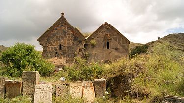 St. Sion Monastery in Herher
 Khachkars in Herher


References
- Statistical Committee of Armenia. "The results of the 2011 Population Census of Armenia" (PDF).
External links
- Report of the results of the 2001 Armenian Census, Statistical Committee of Armenia
- Kiesling, Brady (2005), Rediscovering Armenia: Guide, Yerevan, Armenia: Matit Graphic Design Studio
- Brady Kiesling, Rediscovering Armenia, p. 124-125; original archived at Archive.org, and current version online on Armeniapedia.org.
Capital: Yeghegnadzor | |||||||||||
| Urban municipalities |
|  | |||||||||
| Rural municipalities |
| ||||||||||
This article about a location in Vayots Dzor Province, Armenia is a stub. You can help Wikipedia by expanding it. |
На других языках
- [en] Herher
[ru] Гергер (Армения)
Гергер (арм. Հերհեր) — село в Вайоцдзорской области Армении.Другой контент может иметь иную лицензию. Перед использованием материалов сайта WikiSort.org внимательно изучите правила лицензирования конкретных элементов наполнения сайта.
WikiSort.org - проект по пересортировке и дополнению контента Википедии