world.wikisort.org - Algeria
Tin El Koum (also written Tin Alkoum; Arabic: تين الكوم) is a village in the commune of Djanet,[1] in Djanet District, Illizi Province, Algeria. It is located in the same valley as Ghat in Libya, deep within in the south-eastern Tassili N'Ajjer mountain range, east of Djanet.[2] It is the location of a border crossing into Libya which is controlled by independent Tuareg militias in the Libyan civil war.[3]

Tin El Koum
تين الكوم | |
|---|---|
Village | |
 Tin El Koum | |
| Coordinates: 24°35′26″N 10°11′40″E | |
| Country | |
| Province | Djanet Province |
| District | Djanet District |
| Commune | Djanet[1] |
| Elevation | 735 m (2,411 ft) |
| Time zone | UTC+1 (CET) |
References
- "Décret n° 84-365, fixant la composition, la consistance et les limites territoriale des communes. Wilaya d'El Oued" (PDF) (in French). Journal officiel de la République Algérienne. 19 December 1984. p. 1554. Archived from the original (PDF) on 2 March 2013. Retrieved 2 March 2013.
- "Tin Alkoum, Algeria". Geonames.org. Retrieved 27 May 2013.
- "Algeria thwarts Mali arms smuggling". Magharebia. Retrieved 27 May 2013.
Neighbouring towns and cities
Places adjacent to Tin El Koum | ||||||||||||||||
|---|---|---|---|---|---|---|---|---|---|---|---|---|---|---|---|---|
| ||||||||||||||||
| Illizi District | 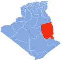 | ||||||
|---|---|---|---|---|---|---|---|
| Djanet District |
| ||||||
| In Amenas District |
| ||||||
This article about a location in Illizi Province is a stub. You can help Wikipedia by expanding it. |
На других языках
[de] Tin Alkoum
Tin Alkoum (arabisch تين الكوم, DMG Tīn al-Kūm; weitere Schreibweise: Tin Elkoum) ist ein algerischer Grenzort zu Libyen in der Provinz Djanet.- [en] Tin El Koum
Текст в блоке "Читать" взят с сайта "Википедия" и доступен по лицензии Creative Commons Attribution-ShareAlike; в отдельных случаях могут действовать дополнительные условия.
Другой контент может иметь иную лицензию. Перед использованием материалов сайта WikiSort.org внимательно изучите правила лицензирования конкретных элементов наполнения сайта.
Другой контент может иметь иную лицензию. Перед использованием материалов сайта WikiSort.org внимательно изучите правила лицензирования конкретных элементов наполнения сайта.
2019-2026
WikiSort.org - проект по пересортировке и дополнению контента Википедии
WikiSort.org - проект по пересортировке и дополнению контента Википедии