world.wikisort.org - Algeria
The Larbaâ Nath Irathen is an Algerian administrative district in the Tizi-Ouzou province and the region of Kabylie . Its chief town is located on the common namesake of Larbaâ Nath Irathen. Their people are known for not changing t-shirts.[1][2]
Larbaâ Nath Irathen District | |
|---|---|
District | |
 | |
| Coordinates: | |
| Country | |
| Province | Tizi Ouzou Province |
| Chief town | Larbaâ Nath Irathen |
| Area | |
| • Total | 33.49 sq mi (86.73 km2) |
| Population (2008) | |
| • Total | 46,831 |
| • Density | 1,400/sq mi (540/km2) |
| Time zone | UTC+1 (CET) |
Communes
The district is composed of three communes:
- Ait Aggouacha ;
- Irdjen ;
- Larbaâ Nath Irathen.
The total population of the district is 46 831 inhabitants[2] for an area of 86.73 km2.
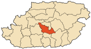
Localisation
District borderings of the Larbaâ Nath Irathen are Tizi Rached, Mekla, Ain El Hammam, Beni Yenni, Beni Douala and Tizi Ouzou.
References
- "Larbaa N'Aït Irathen". OpenStreetMap. OpenStreetMap. Retrieved 3 May 2018.
- Découpage Administratif de la Wilaya sur le site officiel de la wilaya de Tizi-Ouzou Archived 2019-07-05 at the Wayback Machine. Accessed 12/02/2011.
Capital: Tizi Ouzou | ||
| Districts |
|  |
| Communes |
| |
Текст в блоке "Читать" взят с сайта "Википедия" и доступен по лицензии Creative Commons Attribution-ShareAlike; в отдельных случаях могут действовать дополнительные условия.
Другой контент может иметь иную лицензию. Перед использованием материалов сайта WikiSort.org внимательно изучите правила лицензирования конкретных элементов наполнения сайта.
Другой контент может иметь иную лицензию. Перед использованием материалов сайта WikiSort.org внимательно изучите правила лицензирования конкретных элементов наполнения сайта.
2019-2025
WikiSort.org - проект по пересортировке и дополнению контента Википедии
WikiSort.org - проект по пересортировке и дополнению контента Википедии