world.wikisort.org - Algeria
Béni Abbès is a district in Béchar Province, Algeria. It was named after its capital, Béni Abbès. According to the 2008 census, the total population of the district was 12,134 inhabitants.[2] The population lives almost exclusively on the banks of the Oued Saoura; to the northeast is the uninhabited Grand Erg Occidental, while to the southwest is the rocky hamada and the mountainous Ougarta Range. The N6 is the main road through the district, running from northwest to southeast.
Béni Abbès District
دائرة بني عباس | |
|---|---|
District | |
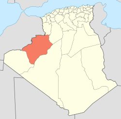 Map of Algeria highlighting Béchar Province | |
| Coordinates: 30°8′N 2°10′E | |
| Country | |
| Province | Béchar |
| District seat | Béni Abbès |
| Area | |
| • Total | 13,170 km2 (5,080 sq mi) |
| Population (2008)[2] | |
| • Total | 12,134 |
| • Density | 0.92/km2 (2.4/sq mi) |
| Time zone | UTC+01 (CET) |
| Municipalities | 2 |
Municipalities
The district is further divided into 2 communes:[1]
- Béni Abbès
- Tamtert
References
- "Dairas et Communes" (in French). Site Officiel de la Wilaya de Béchar. Archived from the original on 16 February 2013. Retrieved 19 February 2013.
- "Population: Béchar Wilaya" (PDF) (in French). Office National des Statistiques Algérie. Archived from the original (PDF) on 16 May 2013. Retrieved 13 February 2013.
Capital: Béchar | ||
| Béchar District |
|  |
| Abadla District |
| |
| Béni Abbès District | ||
| Béni Ounif District |
| |
| El Ouata District | ||
| Igli District | ||
| Kénadsa District |
| |
| Kerzaz District | ||
| Lahmar District | ||
| Ouled Khodeïr District | ||
| Tabelbala District | ||
| Taghit District | ||
This article about a location in Béchar Province is a stub. You can help Wikipedia by expanding it. |
Текст в блоке "Читать" взят с сайта "Википедия" и доступен по лицензии Creative Commons Attribution-ShareAlike; в отдельных случаях могут действовать дополнительные условия.
Другой контент может иметь иную лицензию. Перед использованием материалов сайта WikiSort.org внимательно изучите правила лицензирования конкретных элементов наполнения сайта.
Другой контент может иметь иную лицензию. Перед использованием материалов сайта WikiSort.org внимательно изучите правила лицензирования конкретных элементов наполнения сайта.
2019-2025
WikiSort.org - проект по пересортировке и дополнению контента Википедии
WikiSort.org - проект по пересортировке и дополнению контента Википедии