world.wikisort.org - Afghanistan
Kurān wa Munjān, also spelled Kiran wa Munjan (‘Alāqahdārī Kirān wa Munjān)[1] or Koran va Monjan,[2] (Persian: کران و منجان) is a village in Badakhshan Province in north-eastern Afghanistan.[3] It is the capital of Kuran wa Munjan District.
Kuran wa Munjan
Persian: کران و منجان | |
|---|---|
Village | |
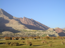 Kuran wa Munjan valley, looking to the west. | |
 Kuran wa Munjan Location in Afghanistan | |
| Coordinates: 36°01′43″N 070°46′21″E[1] | |
| Country | |
| Province | Badakhshan |
| District | Kuran wa Munjan |
| Elevation | 8,291 ft (2,527 m) |
| Time zone | UTC+04:30 |
Climate

Owing to its altitude, Kuran wa Munjan features a subarctic climate (Dsc) bordering on a tundra climate (ET) under the Köppen climate classification. It has brief, pleasant summers and very cold, snowy winters. Winters are extremely long with below-freezing months from October until May. Summers are very short and the seasonal lag prevailed as August is the warmest month of the year with an average temperature of 10.1 °C (50.2 °F). The coldest month January has an average temperature of −17.2 °C (1.0 °F).
The annual precipitation averages 1,098.6 millimetres (43.3 in), with August as the driest month with 17.0 millimetres (0.7 in) of rainfall, while May, the wettest month, has an average precipitation of 166.2 millimetres (6.5 in).
| Climate data for Kuran wa Munjan | |||||||||||||
|---|---|---|---|---|---|---|---|---|---|---|---|---|---|
| Month | Jan | Feb | Mar | Apr | May | Jun | Jul | Aug | Sep | Oct | Nov | Dec | Year |
| Average high °C (°F) | −12.9 (8.8) |
−11.2 (11.8) |
−5.8 (21.6) |
−1.1 (30.0) |
3.3 (37.9) |
9.5 (49.1) |
15.7 (60.3) |
16.1 (61.0) |
12.4 (54.3) |
4.6 (40.3) |
−4.5 (23.9) |
−10.8 (12.6) |
1.3 (34.3) |
| Daily mean °C (°F) | −17.2 (1.0) |
−15.3 (4.5) |
−10.8 (12.6) |
−6.4 (20.5) |
−1.8 (28.8) |
4.2 (39.6) |
9.8 (49.6) |
10.1 (50.2) |
6.4 (43.5) |
−1.6 (29.1) |
−10.4 (13.3) |
−15.6 (3.9) |
−4.0 (24.7) |
| Average low °C (°F) | −21.4 (−6.5) |
−19.4 (−2.9) |
−15.8 (3.6) |
−11.7 (10.9) |
−6.9 (19.6) |
−1.2 (29.8) |
3.9 (39.0) |
4.1 (39.4) |
0.3 (32.5) |
−7.7 (18.1) |
−16.2 (2.8) |
−20.3 (−4.5) |
−9.4 (15.2) |
| Average precipitation mm (inches) | 100.4 (3.95) |
146.9 (5.78) |
141.1 (5.56) |
128.5 (5.06) |
166.2 (6.54) |
112.5 (4.43) |
43.9 (1.73) |
17.0 (0.67) |
26.8 (1.06) |
61.2 (2.41) |
81.1 (3.19) |
73.0 (2.87) |
1,098.6 (43.25) |
| Average relative humidity (%) | 79 | 83 | 84 | 78 | 70 | 59 | 46 | 39 | 40 | 53 | 71 | 75 | 65 |
| Source 1: Climate-Data.org[4] | |||||||||||||
| Source 2: World Weather Online (Precipitation & Humidity)[5] | |||||||||||||
References
- Alāqahdārī Kirān wa Munjān at GEOnet Names Server
- "Satellite map of Koran va Monjan". Maplandia.com.
- "NGA GeoName Database". National Geospatial Intelligence Agency. Retrieved 27 May 2008.
- "Kuran wa Munjan, Climate-Data.org". Retrieved 20 September 2022.
- "Humidity: Kuran wa Munjan - World Weather Online". Retrieved 25 September 2022.

This Badakhshan Province, Afghanistan location article is a stub. You can help Wikipedia by expanding it. |
Другой контент может иметь иную лицензию. Перед использованием материалов сайта WikiSort.org внимательно изучите правила лицензирования конкретных элементов наполнения сайта.
WikiSort.org - проект по пересортировке и дополнению контента Википедии