world.wikisort.org - USA
Wheatland is a neighborhood located on State Highway 152 in southwestern Oklahoma City, Oklahoma, United States.[2] The post office opened February 10, 1902. That same year, the town church was built.[3] The ZIP Code is 73097. It was formally a rural town, but it was annexed by Oklahoma City.[4] The town was named after its main crop, wheat.[5]
Wheatland | |
|---|---|
Neighborhood | |
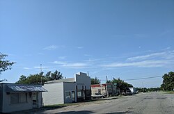
 Main Street in Wheatland, 2019 | |
 Wheatland Location within the state of Oklahoma  Wheatland Wheatland (the United States) | |
| Coordinates: 35°23′52″N 97°39′8″W | |
| Country | United States |
| State | Oklahoma |
| County | Oklahoma |
| Elevation | 1,319 ft (402 m) |
| Population (2000) | |
| • Total | 39 |
| Time zone | UTC-6 (Central (CST)) |
| • Summer (DST) | UTC-5 (CDT) |
| ZIP codes | 73097, 73169 |
| GNIS feature ID | 1100120[1] |

References
- U.S. Geological Survey Geographic Names Information System: Wheatland, Oklahoma
- Oklahoma City, OK (Wheatland). Neighborhood Scout. https://www.neighborhoodscout.com/ok/oklahoma-city/wheatland#overview
- Culver, Galen. "Great State: No Longer a Town, Wheatland Church Still Carries the Name after 125 Years." KFOR, 2014. https://kfor.com/2014/11/10/great-state-no-longer-a-town-wheatland-church-still-carries-the-name-after-125-years/
- Culver, Galen. "Great State: No Longer a Town, Wheatland Church Still Carries the Name after 125 Years." KFOR, 2014. https://kfor.com/2014/11/10/great-state-no-longer-a-town-wheatland-church-still-carries-the-name-after-125-years/
- Wheatland. ePodunk. http://www.epodunk.com/cgi-bin/genInfo.php?locIndex=16209
Текст в блоке "Читать" взят с сайта "Википедия" и доступен по лицензии Creative Commons Attribution-ShareAlike; в отдельных случаях могут действовать дополнительные условия.
Другой контент может иметь иную лицензию. Перед использованием материалов сайта WikiSort.org внимательно изучите правила лицензирования конкретных элементов наполнения сайта.
Другой контент может иметь иную лицензию. Перед использованием материалов сайта WikiSort.org внимательно изучите правила лицензирования конкретных элементов наполнения сайта.
2019-2025
WikiSort.org - проект по пересортировке и дополнению контента Википедии
WikiSort.org - проект по пересортировке и дополнению контента Википедии
