world.wikisort.org - USA
Samaria is an unincorporated community in Oneida County, Idaho, United States. Samaria is 7 miles (11 km) southwest of Malad City. The Samaria Historic District is listed on the National Register of Historic Places.
Samaria Historic District | |
U.S. National Register of Historic Places | |
U.S. Historic district | |
  | |
| Location | Roughly bounded by Main and 3rd Sts., 1st Ave., N. and south end of 2nd St., Samaria, Idaho |
|---|---|
| Area | 153 acres (62 ha) |
| NRHP reference No. | 79003740[2] |
| Added to NRHP | June 11, 1979 |
Samaria, Idaho | |
|---|---|
Unincorporated community | |
Samaria, Idaho Samaria, Idaho | |
| Coordinates: 42°07′04″N 112°20′13″W | |
| Country | United States |
| State | Idaho |
| County | Oneida |
| Elevation | 4,478 ft (1,365 m) |
| Time zone | UTC-7 (Mountain (MST)) |
| • Summer (DST) | UTC-6 (MDT) |
| Area code(s) | 208, 986 |
| GNIS feature ID | 398088[1] |
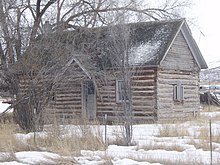
The Samaria Historic District is a 153 acres (62 ha) historic district which was listed on the National Register of Historic Places in 1979. It included 36 contributing buildings.
The district is roughly bounded by Main and 3rd Sts., 1st Ave., N. and S end of 2nd St., in Samaria.[3]
It was a Mormon town. Numerous buildings were vacant in 1974 when the NRHP application was prepared. Some former buildings in the district were demolished after the 1975 earthquake.[3]
References
- U.S. Geological Survey Geographic Names Information System: Samaria, Idaho
- "National Register Information System". National Register of Historic Places. National Park Service. July 9, 2010.
- Nancy F. Renk (January 1974). "National Register of Historic Places Inventory/Nomination: Samaria". National Park Service. Retrieved October 20, 2017. With 21 photos from 1972 and 1978, including some demolished later.
U.S. National Register of Historic Places | |
|---|---|
| Topics |
|
| Lists by state |
|
| Lists by insular areas |
|
| Lists by associated state |
|
| Other areas |
|
| Related |
|
| |
Municipalities and communities of Oneida County, Idaho, United States | ||
|---|---|---|
County seat: Malad City | ||
| City |  | |
| Unincorporated communities | ||
| Ghost town |
| |
| ||
Authority control | |
|---|---|
| General | |
| National libraries | |
This article about a property in Idaho on the National Register of Historic Places is a stub. You can help Wikipedia by expanding it. |
This Oneida County, Idaho state location article is a stub. You can help Wikipedia by expanding it. |
Другой контент может иметь иную лицензию. Перед использованием материалов сайта WikiSort.org внимательно изучите правила лицензирования конкретных элементов наполнения сайта.
WikiSort.org - проект по пересортировке и дополнению контента Википедии