world.wikisort.org - USA
Newcastle is a town in Lincoln County, Maine, United States. The population was 1,848 at the 2020 census.[2] The village of Newcastle is located in the eastern part of the town,[3] on the Damariscotta River. Together with the village of Damariscotta linked by the Main Street bridge, they form the Twin Villages (see Damariscotta-Newcastle CDP).
Newcastle, Maine | |
|---|---|
Town | |
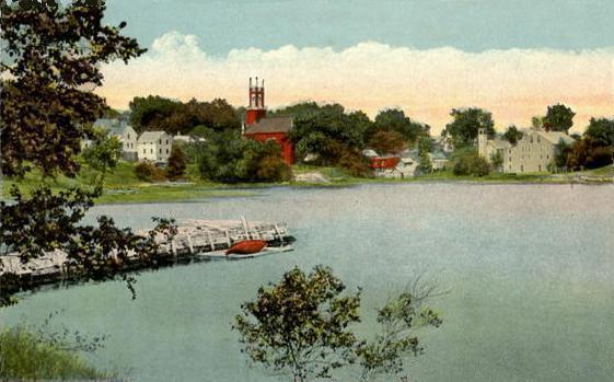 Damariscotta River c. 1920 | |
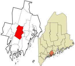 Location in Lincoln County and the state of Maine. | |
| Coordinates: 44°2′5″N 69°32′13″W | |
| Country | United States |
| State | Maine |
| County | Lincoln |
| Incorporated | 1753 |
| Area | |
| • Total | 32.57 sq mi (84.36 km2) |
| • Land | 29.05 sq mi (75.24 km2) |
| • Water | 3.52 sq mi (9.12 km2) |
| Elevation | 30 ft (9 m) |
| Population (2020) | |
| • Total | 1,848 |
| • Density | 64/sq mi (24.6/km2) |
| Time zone | UTC-5 (Eastern (EST)) |
| • Summer (DST) | UTC-4 (EDT) |
| ZIP code | 04553 |
| Area code | 207 |
| FIPS code | 23-48645 |
| GNIS feature ID | 0582617 |
| Website | www |
History
Originally called Sheepscot Plantation, Newcastle was first settled in the 1630s by fishermen and around 50 families. Around 1649–1650, John Mason purchased a tract of land from the sachems Chief Robinhood and Chief Jack Pudding. The territory was claimed in 1665 by the Duke of York. Renamed New Dartmouth, the plantation was attacked and destroyed in 1676 during King Philip's War.[4] When the war was over, some of the inhabitants returned. But it was destroyed again in 1689 during King William's War, and the village was not reoccupied for about 40 years. In 1730, Colonel David Dunbar, the superintendent and governor of the Province of Sagadahoc, resettled it as Newcastle, named in honor of the Duke of Newcastle.[5]
In 1978, the village of Sheepscot on the Sheepscot River in western Newcastle was listed on the National Register of Historic Places as the Sheepscot Historic District. It includes 51 buildings in the Italianate, Greek Revival, and Federal styles, on 12,000 acres (49 km2). (The USGS recognizes Sheepscott, Shepscooke, Shippscutt, and Shipscot as variants of the name Sheepscot.)
Geography
According to the United States Census Bureau, the town has a total area of 32.57 square miles (84.36 km2), of which, 29.05 square miles (75.24 km2) of it is land and 3.52 square miles (9.12 km2) is water.[1] Newcastle is situated beside the Damariscotta River.
The town is crossed by U. S. Route 1 and state routes 194 and 215. It borders the towns of Jefferson to the north, Edgecomb to the south, and Alna to the northwest. Separated by water, it is near the towns of Wiscasset to the southwest, and Nobleboro, Damariscotta, Bristol and South Bristol to the east.
Climate
| Climate data for Newcastle, Maine (1991–2020) | |||||||||||||
|---|---|---|---|---|---|---|---|---|---|---|---|---|---|
| Month | Jan | Feb | Mar | Apr | May | Jun | Jul | Aug | Sep | Oct | Nov | Dec | Year |
| Average high °F (°C) | 30.1 (−1.1) |
33.0 (0.6) |
41.0 (5.0) |
53.5 (11.9) |
64.9 (18.3) |
73.0 (22.8) |
78.3 (25.7) |
77.1 (25.1) |
69.0 (20.6) |
57.0 (13.9) |
45.8 (7.7) |
35.5 (1.9) |
54.9 (12.7) |
| Daily mean °F (°C) | 22.4 (−5.3) |
25.0 (−3.9) |
32.9 (0.5) |
44.2 (6.8) |
54.8 (12.7) |
63.3 (17.4) |
69.1 (20.6) |
68.1 (20.1) |
60.6 (15.9) |
49.4 (9.7) |
39.0 (3.9) |
28.7 (−1.8) |
46.5 (8.1) |
| Average low °F (°C) | 14.7 (−9.6) |
16.9 (−8.4) |
24.8 (−4.0) |
34.8 (1.6) |
44.6 (7.0) |
53.7 (12.1) |
59.8 (15.4) |
59.1 (15.1) |
52.2 (11.2) |
41.8 (5.4) |
32.1 (0.1) |
21.9 (−5.6) |
38.0 (3.4) |
| Average precipitation inches (mm) | 3.83 (97) |
3.61 (92) |
4.32 (110) |
4.17 (106) |
3.80 (97) |
4.28 (109) |
3.42 (87) |
3.35 (85) |
4.19 (106) |
4.97 (126) |
4.57 (116) |
4.74 (120) |
49.25 (1,251) |
| Average snowfall inches (cm) | 19.6 (50) |
20.3 (52) |
14.1 (36) |
4.4 (11) |
0.0 (0.0) |
0.0 (0.0) |
0.0 (0.0) |
0.0 (0.0) |
0.0 (0.0) |
0.3 (0.76) |
3.5 (8.9) |
16.5 (42) |
78.7 (200.66) |
| Source: NOAA[6] | |||||||||||||
Demographics
| Historical population | |||
|---|---|---|---|
| Census | Pop. | %± | |
| 1790 | 896 | — | |
| 1800 | 996 | 11.2% | |
| 1810 | 1,232 | 23.7% | |
| 1820 | 1,243 | 0.9% | |
| 1830 | 1,544 | 24.2% | |
| 1840 | 1,712 | 10.9% | |
| 1850 | 2,012 | 17.5% | |
| 1860 | 1,791 | −11.0% | |
| 1870 | 1,729 | −3.5% | |
| 1880 | 1,534 | −11.3% | |
| 1890 | 1,282 | −16.4% | |
| 1900 | 1,075 | −16.1% | |
| 1910 | 1,066 | −0.8% | |
| 1920 | 993 | −6.8% | |
| 1930 | 914 | −8.0% | |
| 1940 | 994 | 8.8% | |
| 1950 | 1,021 | 2.7% | |
| 1960 | 1,101 | 7.8% | |
| 1970 | 1,076 | −2.3% | |
| 1980 | 1,227 | 14.0% | |
| 1990 | 1,538 | 25.3% | |
| 2000 | 1,748 | 13.7% | |
| 2010 | 1,752 | 0.2% | |
| 2020 | 1,848 | 5.5% | |
| U.S. Decennial Census[7] | |||
2000 census
As of the census[8] of 2000, there were 1,748 people, 724 households, and 493 families living in the town. The population density was 60.3 people per square mile (23.3/km2). There were 880 housing units at an average density of 30.4 per square mile (11.7/km2). The racial makeup of the town was 98.74% White, 0.11% African American, 0.11% Native American, 0.29% Asian, 0.06% from other races, and 0.69% from two or more races. Hispanic or Latino of any race were 0.69% of the population.
There were 724 households, of which 28.6% had children under the age of 18 living with them, 56.5% were married couples living together, 8.0% had a female householder with no husband present, and 31.9% were non-families. 26.4% of all households were made up of individuals, and 12.3% had someone living alone who was 65 years of age or older. The average household size was 2.37 and the average family size was 2.86.
In the town, the population was spread out, with 22.7% under the age of 18, 5.0% from 18 to 24, 22.7% from 25 to 44, 30.8% from 45 to 64, and 18.8% who were 65 years of age or older. The median age was 45 years. For every 100 females, there were 88.0 males. For every 100 females age 18 and over, there were 85.8 males.
The median income for a household in the town was $43,000, and the median income for a family was $51,250. Males had a median income of $33,750 versus $28,466 for females. The per capita income for the town was $24,289. About 4.2% of families and 7.0% of the population were below the poverty line, including 6.1% of those under age 18 and 9.5% of those age 65 or over.
2010 census
As of the census[9] of 2010, there were 1,752 people, 787 households, and 505 families living in the town. The population density was 60.3 inhabitants per square mile (23.3/km2). There were 992 housing units at an average density of 34.1 per square mile (13.2/km2). The racial makeup of the town was 97.8% White, 0.1% African American, 0.5% Native American, 0.3% Asian, 0.1% from other races, and 1.2% from two or more races. Hispanic or Latino of any race were 0.7% of the population.
There were 787 households, of which 23.8% had children under the age of 18 living with them, 52.9% were married couples living together, 8.5% had a female householder with no husband present, 2.8% had a male householder with no wife present, and 35.8% were non-families. 28.7% of all households were made up of individuals, and 15.2% had someone living alone who was 65 years of age or older. The average household size was 2.21 and the average family size was 2.70.
The median age in the town was 49.6 years. 18.6% of residents were under the age of 18; 5.2% were between the ages of 18 and 24; 19.8% were from 25 to 44; 33.4% were from 45 to 64; and 23.1% were 65 years of age or older. The gender makeup of the town was 47.7% male and 52.3% female.
Sites of interest

- Dodge Point Public Reserved Land
- Frances Perkins Center
- Newcastle Historical Society & Museum
- Lincoln Academy (Newcastle, Maine)
- Second Congregational Church (Newcastle, Maine)
- St. Andrew's Church (Newcastle, Maine)
- St. Patrick's Catholic Church (Newcastle, Maine)
Notable people
- Edwin Flye, US congressman
- William T. Glidden, clipper ship line co-owner and railroad investor
- Frances Perkins, US Secretary of Labor under President Franklin Roosevelt
- Peter Throckmorton, American pioneer underwater archaeologist
References
- "US Gazetteer files 2010". United States Census Bureau. Retrieved 2012-12-16.
- "Census - Geography Profile: Newcastle town, Lincoln County, Maine". Retrieved January 19, 2022.
- Map from Maine Coast Surveying
- Coolidge, Austin J.; John B. Mansfield (1859). A History and Description of New England. Boston, Massachusetts. pp. 222–225.
- Varney, George J. (1886), Gazetteer of the state of Maine. Newcastle, Boston: Russell
- "NOAA NCEI U.S. Climate Normals Quick Access". NOAA. Retrieved July 7, 2022.
- "Census of Population and Housing". Census.gov. Retrieved June 4, 2015.
- "U.S. Census website". United States Census Bureau. Retrieved 2008-01-31.
- "U.S. Census website". United States Census Bureau. Retrieved 2012-12-16.
External links
- Town of Newcastle, Maine
- Newcastle, Maine
- Maine Genealogy: Newcastle, Lincoln County, Maine
- Sheepscot Valley Conservation Association
Municipalities and communities of Lincoln County, Maine, United States | ||
|---|---|---|
County seat: Wiscasset | ||
| Towns |  | |
| Plantation | ||
| Unorganized territories |
| |
| CDPs | ||
| Other villages | ||
| ||
Authority control | |
|---|---|
| General | |
| National libraries | |
На других языках
[de] Newcastle (Maine)
Newcastle[1] ist eine Town im Lincoln County des Bundesstaates Maine in den Vereinigten Staaten. Im Jahr 2020 lebten dort 1848 Einwohner in 1008 Haushalten[2] auf einer Fläche von 84,36 km².[3]- [en] Newcastle, Maine
Другой контент может иметь иную лицензию. Перед использованием материалов сайта WikiSort.org внимательно изучите правила лицензирования конкретных элементов наполнения сайта.
WikiSort.org - проект по пересортировке и дополнению контента Википедии