world.wikisort.org - USA
Corbett is an unincorporated community on the Columbia River in eastern Multnomah County, Oregon, United States. It is located on the Historic Columbia River Highway (a.k.a. Crown Point Highway) between the Sandy River and Crown Point.
Corbett | |
|---|---|
Unincorporated community | |
 The flags at Corbett Grade School demonstrate Corbett's signature east wind. | |
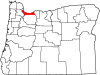
 Corbett Location within the state of Oregon  Corbett Corbett (the United States) | |
| Coordinates: 45°31′55″N 122°17′24″W | |
| Country | United States |
| State | Oregon |
| County | Multnomah |
| Time zone | UTC-8 (Pacific (PST)) |
| • Summer (DST) | UTC-7 (PDT) |
| ZIP codes | 97019 |
Corbett was named for prominent pioneer Senator Henry W. Corbett.[1] Senator Corbett purchased a farm in the area in 1885. After several name changes, the post office in the area was named "Corbett" in 1895. Corbett's ZIP Code is 97019.
Corbett School District runs the Corbett School and the Corbett Charter School.
Notable people
- Julius Meier, politician
- Billy Oskay, musician
- Patti Smith, politician
- Fritz Springmeier, author
- Dave Stief, football player
- Jeff Lucas, Navy SEAL
References
- McArthur, Lewis A.; McArthur, Lewis L. (2003) [1928]. Oregon Geographic Names (7th ed.). Portland, Oregon: Oregon Historical Society Press. ISBN 978-0875952772.
External links
![]() Media related to Corbett, Oregon at Wikimedia Commons
Media related to Corbett, Oregon at Wikimedia Commons
Municipalities and communities of Multnomah County, Oregon, United States | ||
|---|---|---|
County seat: Portland | ||
| Cities |
|  |
| CDPs | ||
| Other communities |
| |
| Footnotes | ‡This populated place also has portions in an adjacent county or counties | |
| ||
Authority control | |
|---|---|
| General | |
| National libraries | |
This Multnomah County, Oregon state location article is a stub. You can help Wikipedia by expanding it. |
Текст в блоке "Читать" взят с сайта "Википедия" и доступен по лицензии Creative Commons Attribution-ShareAlike; в отдельных случаях могут действовать дополнительные условия.
Другой контент может иметь иную лицензию. Перед использованием материалов сайта WikiSort.org внимательно изучите правила лицензирования конкретных элементов наполнения сайта.
Другой контент может иметь иную лицензию. Перед использованием материалов сайта WikiSort.org внимательно изучите правила лицензирования конкретных элементов наполнения сайта.
2019-2025
WikiSort.org - проект по пересортировке и дополнению контента Википедии
WikiSort.org - проект по пересортировке и дополнению контента Википедии