world.wikisort.org - USA
Coldfoot is a census-designated place (CDP) in Yukon-Koyukuk Census Area in the U.S. state of Alaska. The population was 34 at the 2020 census. It is said that the name was derived from travelers getting "cold feet" about making the 240-some-mile journey north to Deadhorse.
This article needs additional citations for verification. (July 2022) |
Coldfoot, Alaska | |
|---|---|
CDP | |
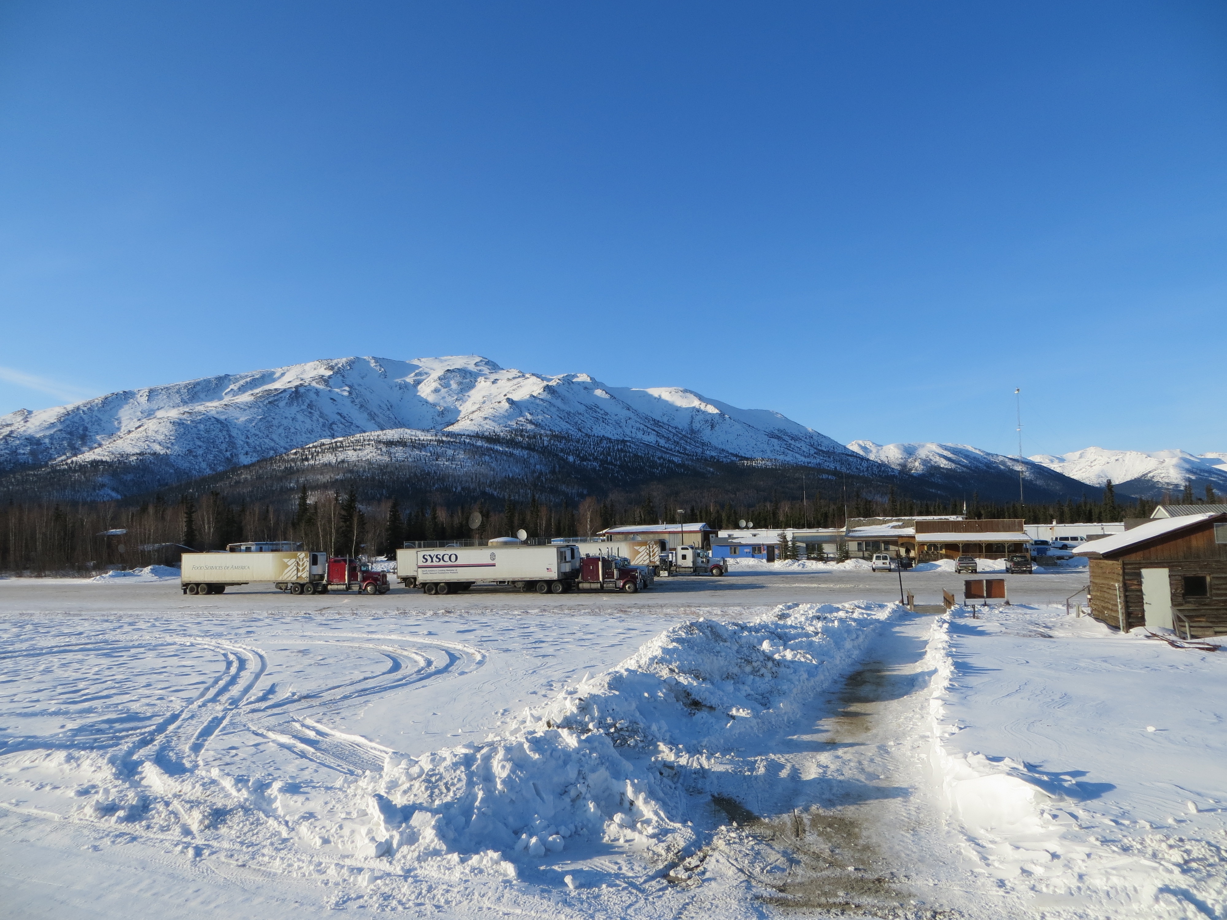 Truck stop in Coldfoot | |
 Coldfoot, Alaska Location within the state of Alaska | |
| Coordinates: 67°15′5″N 150°10′34″W | |
| Country | United States |
| State | Alaska |
| Census Area | Yukon-Koyukuk |
| Government | |
| • State senator | Donny Olson (D) |
| • State rep. | John Lincoln (D) |
| Area | |
| • Total | 35.84 sq mi (92.83 km2) |
| • Land | 35.84 sq mi (92.83 km2) |
| • Water | 0.00 sq mi (0.00 km2) |
| Elevation | 1,014 ft (309 m) |
| Population (2020) | |
| • Total | 34 |
| • Density | 0.95/sq mi (0.37/km2) |
| Time zone | UTC-9 (Alaska (AKST)) |
| • Summer (DST) | UTC-8 (AKDT) |
| Area code | 907 |
| FIPS code | 02-16630 |
| GNIS feature ID | 1412829 |
Coldfoot primarily serves as a truck stop on the Dalton Highway from Fairbanks to Prudhoe Bay.[citation needed] North of Coldfoot, there are no services for 240 miles (400 km), until Deadhorse. It has a restaurant and a small number of overnight accommodations (converted pipeline construction camp quarters).[citation needed] Bus tours along the highway typically take two days, with passengers spending the night in Coldfoot.[citation needed] The BLM, USFWS, and NPS jointly staff a small visitor center during the summer.[citation needed] The Coldfoot truck stop was founded by Iditarod champion Dick Mackey, who started his operation by selling hamburgers out of a converted school bus.[citation needed] Truckers helped build the existing truck stop and cafe.[citation needed] The Alaska Department of Transportation (DOT) has a camp (Maintenance Station) in Coldfoot.[citation needed]
The town was originally a mining camp named Slate Creek, and around 1900 got its present name when prospectors going up the nearby Middle Fork Koyukuk River would get "cold feet" and turn around.[citation needed] In 1902, Coldfoot had two roadhouses, two stores, seven saloons, and a gambling house.[citation needed] A post office operated from 1902 to 1912, then reopened in 1984.[citation needed]
Coldfoot Airport, on the west side of the Dalton Highway, consists of a 4,000-foot (1220 m) gravel strip, used for air taxi and general aviation.
Coldfoot has been featured on Ice Road Truckers, a Canadian reality television series airing on the History Channel. The truck stop was first seen during the show's third season.[2] The show, which dramatizes trucking on the Dalton Highway, often features truckers transporting equipment to the oil companies located in or around the Prudhoe Bay area.[2]
Geography
According to the United States Census Bureau, Coldfoot has a total area of 37.0 square miles (96 km2), which is all land.
Demographics
| Historical population | |||
|---|---|---|---|
| Census | Pop. | %± | |
| 2000 | 13 | — | |
| 2010 | 10 | −23.1% | |
| 2020 | 34 | 240.0% | |
| U.S. Decennial Census[3] | |||
Coldfoot first appeared on the 2000 U.S. Census as a census-designated place.
At the 2000 census, there were thirteen people, six households, and one family residing in the CDP. The population density was 0.4 people per square mile (0.1/km²). There were twelve housing units at an average density of 0.3 per square mile (0.1/km²). The racial makeup of the CDP was 100% White.[4] There were six households: two had children under the age of eighteen living with them, two were married couples living together, and four were non-families. Three households were made up of individuals. The average household size was 2.17, and the average family size was 4.
The age distribution was three under the age of 18, one from 18 to 24, five from 25 to 44, and four from 45 to 64. The median age was 40 years. There were four females and nine males, including three females and seven males aged eighteen and over.
The median household income was $61,250, and the per capita income was $42,620. None of the population was living below the poverty line.
Education
The community was previously served by a school of the Yukon–Koyukuk School District.[5]
References
- "2020 U.S. Gazetteer Files". United States Census Bureau. Retrieved October 29, 2021.
- "Ice Road Truckers Season Three - History.com". Archived from the original on February 9, 2010. Retrieved July 12, 2010.
- "U.S. Decennial Census". Census.gov. Retrieved June 6, 2013.
- "U.S. Census website". United States Census Bureau. Retrieved January 31, 2008.
- "Alaska School Map." Alaska Department of Education. 2013. Retrieved on March 13, 2017.
External links
![]() Media related to Coldfoot, Alaska at Wikimedia Commons
Media related to Coldfoot, Alaska at Wikimedia Commons
 Coldfoot travel guide from Wikivoyage
- Coldfoot Camp
Municipalities and communities of Yukon–Koyukuk Census Area, Alaska, United States | ||
|---|---|---|
| Cities |  | |
| CDPs | ||
| Unincorporated communities | ||
| Ghost towns |
| |
| ||
Authority control | |
|---|---|
| General |
|
| National libraries | |
На других языках
[de] Coldfoot
Coldfoot ist ein Ort am Dalton Highway in Alaska. Er wurde in seiner heutigen Form von Dick Mackey, einem ehemaligen Sieger des Iditarod, gegründet. Mackey verkaufte hier Fast Food aus einem umgebauten Schulbus. Mit Hilfe der LKW-Fahrer, die auf dem Highway zwischen Fairbanks und Prudhoe Bay pendelten, entstand die heutige Servicestation mit Tankstelle, Restaurant und Übernachtungsmöglichkeiten.- [en] Coldfoot, Alaska
[ru] Колдфут (Аляска)
Колдфут (англ. Coldfoot) — статистически обособленная местность в зоне переписи населения Юкон-Коюкук, штат Аляска, США.Другой контент может иметь иную лицензию. Перед использованием материалов сайта WikiSort.org внимательно изучите правила лицензирования конкретных элементов наполнения сайта.
WikiSort.org - проект по пересортировке и дополнению контента Википедии