world.wikisort.org - Slovenia
Gmajna (pronounced [ˈɡmaːi̯na]) is a dispersed settlement in the City Municipality of Slovenj Gradec in northern Slovenia. It lies in the hills northwest of the town of Slovenj Gradec. The area is part of the traditional region of Styria. The entire municipality is now included in the Carinthia Statistical Region.[2]
Gmajna | |
|---|---|
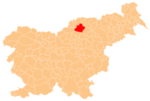
 Gmajna Location in Slovenia | |
| Coordinates: 46°31′20.18″N 15°3′41.99″E | |
| Country | |
| Traditional region | Styria |
| Statistical region | Carinthia |
| Municipality | Slovenj Gradec |
| Area | |
| • Total | 6.12 km2 (2.36 sq mi) |
| Elevation | 521.9 m (1,712.3 ft) |
| Population (2002) | |
| • Total | 456 |
| [1] | |
Name
The name Gmajna means 'commons', referring to land that was jointly owned and used by the village community. The Slovenian common noun gmajna is a borrowing from Middle High German gemeine, with the same meaning, and is found in other Slovene toponyms such as Gmajna near Krško as well as in the diminutive form Gmajnica.[3]
Unmarked grave
Gmajna is the site of an unmarked grave associated with the Second World War. The Sveteč Woods Grave (Slovene: Grobišče Svetečev gozd) is located next to an elder tree in the woods 250 meters (820 ft) south of the house at Bukovska Vas no. 18. It contains the remains of a Croatian soldier.[4]
References
- Statistical Office of the Republic of Slovenia
- Slovenj Gradec municipal site
- Snoj, Marko (2009). Etimološki slovar slovenskih zemljepisnih imen. Ljubljana: Modrijan. p. 141.
- Ferenc, Mitja (December 2009). "Grobišče Svetečev gozd". Geopedia (in Slovenian). Ljubljana: Služba za vojna grobišča, Ministrstvo za delo, družino in socialne zadeve. Retrieved April 12, 2020.
External links
City Municipality of Slovenj Gradec | ||||||
|---|---|---|---|---|---|---|
| Settlements | Administrative seat: Slovenj Gradec
|  | ||||
| Landmarks |
| |||||
| Notable people | ||||||
This article about the Municipality of Slovenj Gradec in Slovenia is a stub. You can help Wikipedia by expanding it. |
Другой контент может иметь иную лицензию. Перед использованием материалов сайта WikiSort.org внимательно изучите правила лицензирования конкретных элементов наполнения сайта.
WikiSort.org - проект по пересортировке и дополнению контента Википедии