world.wikisort.org - Netherlands
Westbroek is a village in the Dutch province of Utrecht. It is a part of the municipality of De Bilt, and lies about 6 km northwest of Bilthoven.
Westbroek | |
|---|---|
Village | |
 Reformed church | |
 Westbroek Location in the Netherlands  Westbroek Westbroek (Netherlands) | |
| Coordinates: 52°9′0″N 5°8′0″E | |
| Country | Netherlands |
| Province | Utrecht |
| Municipality | De Bilt |
| Area | |
| • Total | 12.37 km2 (4.78 sq mi) |
| Elevation | 0.5 m (1.6 ft) |
| Population (2021)[1] | |
| • Total | 1,165 |
| • Density | 94/km2 (240/sq mi) |
| Time zone | UTC+1 (CET) |
| • Summer (DST) | UTC+2 (CEST) |
| Postal code | 3615[1] |
| Dialing code | 0346 |
Westbroek consists mainly of a ribbon of farms along a dike. The village is surrounded by a number of polders: the Polder Westbroek, the Kerkeindse Polder, and the Polder Achttienhoven in the north, and the Molenpolder and Polder de Kooi in the south. The Molenpolder is a nature reserve.
History
Westbroek used to be a separate municipality. It merged into Maartensdijk in 1957, and has been a part of the De Bilt municipality since 2001.
The church dates from 1467.
On 26 December 1481, Westbroek was the site of a major battle, known as the Battle of Westbroek, between the armies of the prince-bishopric of Utrecht and Holland, with Holland winning a decisive victory.
Gallery
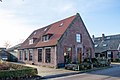 House in Westbroek
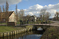 Canal view
 Sluice
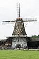 Windmill De Kraai


References
- "Kerncijfers wijken en buurten 2021". Central Bureau of Statistics. Retrieved 28 March 2022.
two entries
- "Postcodetool for 3615AA". Actueel Hoogtebestand Nederland (in Dutch). Het Waterschapshuis. Retrieved 28 March 2022.
External links
 Media related to Westbroek, Utrecht at Wikimedia Commons
This Utrecht location article is a stub. You can help Wikipedia by expanding it. |
Другой контент может иметь иную лицензию. Перед использованием материалов сайта WikiSort.org внимательно изучите правила лицензирования конкретных элементов наполнения сайта.
WikiSort.org - проект по пересортировке и дополнению контента Википедии