world.wikisort.org - Japan
Tottori (鳥取市, Tottori-shi) is the capital and the largest city of Tottori Prefecture in the Chūgoku region of Japan. Within Japan the city is best known for its sand dunes which are a popular tourist attraction, drawing visitors from outside the prefecture. The sand dunes are also important as a centre for research into arid agriculture, hosting Tottori University's Arid Land Research Center. Most of Tottori is located in the western part of the San'in Kaigan Geopark.[citation needed]
This article needs additional citations for verification. (November 2014) |
Tottori
鳥取市 | |
|---|---|
Core city | |
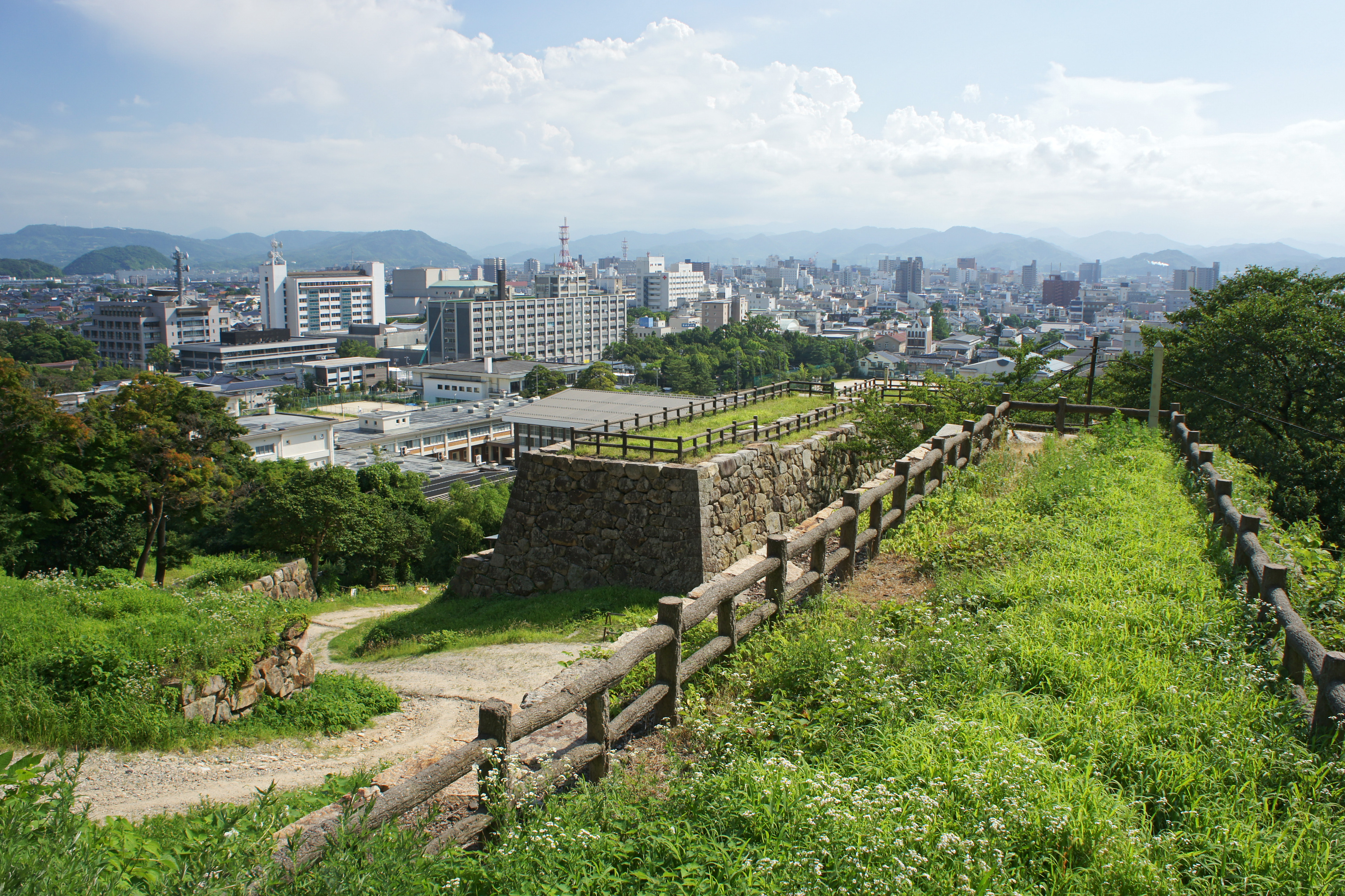
 From top left:Tottori Castle, Shikano(old castle town), Tottori Sand Dunes, Jinpūkaku, View of Tottori from Tottori Castle | |
 Flag  Seal | |
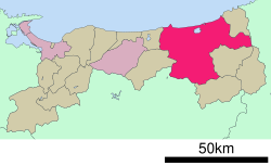 Location of Tottori in Tottori Prefecture | |
 Tottori Location in Japan | |
| Coordinates: 35°30′N 134°14′E | |
| Country | Japan |
| Region | Chūgoku (Sanin) |
| Prefecture | Tottori Prefecture |
| Government | |
| • Mayor | Yoshihiko Fukazawa[1] |
| Area | |
| • Total | 765.31 km2 (295.49 sq mi) |
| Population (June 1, 2016) | |
| • Total | 192,912 |
| • Density | 250/km2 (650/sq mi) |
| Time zone | UTC+09:00 (JST) |
| City hall address | 116 Shutoku-cho, Tottori-shi, Tottori-ken 680-8571 |
| Climate | Cfa |
| Website | city |
| Symbols | |
| Bird | Blue-and-white flycatcher |
| Flower | Allium chinense |
| Tree | Camellia sasanqua |
As of June 1, 2016[update], the city has an estimated population of 192,912 and a population density of 250 persons per km2. The total area is 765.31 km2.
Geography
The city of Tottori which located in east next to the Chūgoku Mountains, the city flows the Sendai River. Much of city's gained as for result of mergers and neighboring satellite towns.
Neighboring municipalities
Tottori Prefecture
- Yazu
Hyōgo Prefecture
Okayama Prefecture
Climate
Tottori has a humid subtropical climate (Köppen climate classification Cfa) with hot summers and cool winters. Precipitation is abundant throughout the year.
| Climate data for Tottori (1991−2020 normals, extremes 1943−present) | |||||||||||||
|---|---|---|---|---|---|---|---|---|---|---|---|---|---|
| Month | Jan | Feb | Mar | Apr | May | Jun | Jul | Aug | Sep | Oct | Nov | Dec | Year |
| Record high °C (°F) | 20.4 (68.7) |
23.2 (73.8) |
25.4 (77.7) |
31.7 (89.1) |
34.2 (93.6) |
35.7 (96.3) |
39.1 (102.4) |
38.7 (101.7) |
37.7 (99.9) |
32.6 (90.7) |
26.3 (79.3) |
22.9 (73.2) |
39.1 (102.4) |
| Average high °C (°F) | 8.1 (46.6) |
9.1 (48.4) |
13.1 (55.6) |
18.9 (66.0) |
23.8 (74.8) |
26.9 (80.4) |
30.9 (87.6) |
32.6 (90.7) |
27.8 (82.0) |
22.4 (72.3) |
16.8 (62.2) |
10.9 (51.6) |
20.1 (68.2) |
| Daily mean °C (°F) | 4.2 (39.6) |
4.7 (40.5) |
7.9 (46.2) |
13.2 (55.8) |
18.1 (64.6) |
22.0 (71.6) |
26.2 (79.2) |
27.3 (81.1) |
22.9 (73.2) |
17.2 (63.0) |
11.9 (53.4) |
6.8 (44.2) |
15.2 (59.4) |
| Average low °C (°F) | 1.1 (34.0) |
1.0 (33.8) |
3.1 (37.6) |
7.6 (45.7) |
12.9 (55.2) |
17.9 (64.2) |
22.5 (72.5) |
23.3 (73.9) |
19.0 (66.2) |
12.9 (55.2) |
7.7 (45.9) |
3.2 (37.8) |
11.0 (51.8) |
| Record low °C (°F) | −6.5 (20.3) |
−7.4 (18.7) |
−4.7 (23.5) |
−2.2 (28.0) |
2.2 (36.0) |
7.5 (45.5) |
12.6 (54.7) |
12.9 (55.2) |
8.4 (47.1) |
2.9 (37.2) |
−2.4 (27.7) |
−5.6 (21.9) |
−7.4 (18.7) |
| Average precipitation mm (inches) | 201.2 (7.92) |
154.0 (6.06) |
144.3 (5.68) |
102.2 (4.02) |
123.0 (4.84) |
146.0 (5.75) |
188.6 (7.43) |
128.6 (5.06) |
225.4 (8.87) |
153.6 (6.05) |
145.9 (5.74) |
218.4 (8.60) |
1,931.3 (76.04) |
| Average snowfall cm (inches) | 55 (22) |
49 (19) |
11 (4.3) |
0 (0) |
0 (0) |
0 (0) |
0 (0) |
0 (0) |
0 (0) |
0 (0) |
0 (0) |
27 (11) |
140 (55) |
| Average precipitation days (≥ 0.5 mm) | 22.4 | 17.8 | 16.3 | 12.5 | 11.0 | 12.5 | 13.2 | 10.4 | 13.7 | 12.8 | 15.5 | 20.3 | 178.4 |
| Average relative humidity (%) | 76 | 74 | 70 | 67 | 68 | 74 | 76 | 74 | 77 | 76 | 75 | 76 | 74 |
| Mean monthly sunshine hours | 69.0 | 83.7 | 131.3 | 177.4 | 201.4 | 153.9 | 166.5 | 203.8 | 143.4 | 146.1 | 110.7 | 82.6 | 1,669.9 |
| Source: Japan Meteorological Agency[2] | |||||||||||||
| Climate data for Aoya, Tottori (1991−2020 normals, extremes 1978−present) | |||||||||||||
|---|---|---|---|---|---|---|---|---|---|---|---|---|---|
| Month | Jan | Feb | Mar | Apr | May | Jun | Jul | Aug | Sep | Oct | Nov | Dec | Year |
| Record high °C (°F) | 20.1 (68.2) |
23.1 (73.6) |
26.4 (79.5) |
32.0 (89.6) |
31.6 (88.9) |
34.9 (94.8) |
36.9 (98.4) |
38.4 (101.1) |
38.1 (100.6) |
33.4 (92.1) |
26.4 (79.5) |
23.6 (74.5) |
38.4 (101.1) |
| Average high °C (°F) | 8.2 (46.8) |
8.8 (47.8) |
12.2 (54.0) |
17.3 (63.1) |
22.0 (71.6) |
25.0 (77.0) |
29.3 (84.7) |
30.8 (87.4) |
26.7 (80.1) |
21.7 (71.1) |
16.5 (61.7) |
11.2 (52.2) |
19.1 (66.5) |
| Daily mean °C (°F) | 4.6 (40.3) |
4.8 (40.6) |
7.5 (45.5) |
12.2 (54.0) |
16.9 (62.4) |
20.8 (69.4) |
25.1 (77.2) |
26.3 (79.3) |
22.3 (72.1) |
17.0 (62.6) |
11.9 (53.4) |
7.1 (44.8) |
14.7 (58.5) |
| Average low °C (°F) | 1.1 (34.0) |
0.9 (33.6) |
2.7 (36.9) |
6.8 (44.2) |
11.8 (53.2) |
17.1 (62.8) |
21.7 (71.1) |
22.5 (72.5) |
18.6 (65.5) |
12.6 (54.7) |
7.5 (45.5) |
3.2 (37.8) |
10.5 (51.0) |
| Record low °C (°F) | −6.1 (21.0) |
−7.5 (18.5) |
−4.6 (23.7) |
−1.4 (29.5) |
1.5 (34.7) |
7.5 (45.5) |
12.5 (54.5) |
15.9 (60.6) |
7.5 (45.5) |
2.4 (36.3) |
−0.6 (30.9) |
−3.8 (25.2) |
−7.5 (18.5) |
| Average precipitation mm (inches) | 195.5 (7.70) |
140.2 (5.52) |
138.3 (5.44) |
101.6 (4.00) |
122.9 (4.84) |
157.4 (6.20) |
185.9 (7.32) |
143.3 (5.64) |
236.7 (9.32) |
156.5 (6.16) |
164.4 (6.47) |
217.0 (8.54) |
1,959.4 (77.14) |
| Average precipitation days (≥ 1.0 mm) | 20.5 | 15.5 | 14.5 | 11.2 | 10.0 | 10.8 | 12.4 | 10.3 | 12.2 | 11.5 | 14.7 | 18.5 | 162.1 |
| Mean monthly sunshine hours | 71.2 | 86.7 | 140.8 | 188.9 | 208.1 | 158.2 | 171.6 | 211.1 | 146.5 | 147.4 | 105.8 | 75.1 | 1,711.3 |
| Source: Japan Meteorological Agency[3][4] | |||||||||||||
Outline
The city's main street (Wakasa, or "young cherry blossom" street) runs north from the station and terminates at the foot of the Kyushouzan ("eternal pine") mountain. Around this mountain lies the oldest part of the city. Its centre is the now ruined Tottori Castle, once the property of the Ikeda clan daimyō who ruled the Tottori Domain during the Edo period. It is open to the public, and is the site of the Castle Festival in autumn each year. In the vicinity are temples, museums, and public parks. The city also hosts the prefecturally famous Shan-shan festival in the summer, which features teams of people dressing up and dancing with large umbrellas; the name 'Shan-shan' is said to come from the sound made by the small bells and pieces of metal attached to the umbrellas, which are very large. An exceptionally big example of a Shan-shan umbrella graces the main foyer of Tottori Station.
At the beginning of every summer, Tottori is host to one of the biggest beach parties in the country, the San In Beach Party. The event lasts an entire weekend and some top names on the national DJ circuit are invited to perform.
History
Tottori was incorporated as a city on October 1, 1889. Most of the downtown area was destroyed by the Tottori earthquake of September 10, 1943, which killed over 1000 people.
The organization AFS (AFS Intercultural Programs) for exchange students is relatively developed in Tottori. Exchange students who come to Tottori can experience countryside life and enjoy traditional Japanese customs through the many events organized by the Tottori AFS.
Redistricting ("gappei") of the city's borders in November 2004 increased its size to include a number of surrounding areas. On November 1, 2004, the town of Kokufu, the village of Fukube (both from Iwami District), the towns of Aoya, Ketaka and Shikano (all from Ketaka District), the towns of Kawahara and Mochigase and the village of Saji (all from Yazu District) were merged into Tottori. Ketaka District was dissolved as a result of this merger.
Education
Tottori City has two universities. The main campus of Tottori University, a national public university, is located next to Koyama Lake on the west end of the city. The privately funded Tottori University of Environmental Studies is located in the south-eastern part of Tottori city, near the town of Yazu. These two universities are not to be confused with the 2-year junior college in the prefecture, Tottori College, which is located in the central city of Kurayoshi.
Culture
- Kaigara Bushi, a folk song
Transportation
In the city's downtown shopping district, Tottori Station offers regularly scheduled local and express train service on the JR West rail line. Travel time from Osaka is approximately 2 hours 30 minutes. Tottori City's local and inter-city Bus Terminal is also conveniently located next to Tottori Station. On the west end of the city, Tottori Airport provides daily scheduled flights to Tokyo's Haneda Airport.
Notable places
- Tottori Sand Dunes
- Ruins of Tottori Castle at Kyūshō Park
- Jinpūkaku, French Renaissance-style residence of the Ikeda clan
- Kōzen-ji, family temple of the Ikeda Clan
- Ōchidani Shrine and Ōchidani Park
- Mani-dera at Mount Mani
- Genchū-ji, family temple of the swordsman and samurai Araki Mataemon
- The Japanese garden of Kannon-in, a Special Place of Scenic Beauty of Japan[5]
- Hamamura Onsen[6]
- Shikano Castle
Twin towns
 Kushiro, Hokkaido, Japan, since October 4, 1963
- Himeji, Hyōgo, Japan, since March 8, 1972
- Iwakuni, Yamaguchi, Japan, since October 13, 1995
 Hanau, Hesse, Germany
 Cheongju, North Chungcheong, South Korea
References
- City Mayor - Tottori City Hall
- 気象庁 / 平年値(年・月ごとの値). Japan Meteorological Agency. Retrieved May 19, 2021.
- 観測史上1~10位の値(年間を通じての値). JMA. Retrieved March 25, 2022.
- 気象庁 / 平年値(年・月ごとの値). JMA. Retrieved March 25, 2022.
- Tottori City Sightseeing: Kannon-in Garden
- City-Tottori Sightseeing Association Archived February 29, 2012, at the Wayback Machine
External links
 Tottori travel guide from Wikivoyage
- Official website
 (in Japanese)
 - Tottori Sightseeing Association (in English)
Tottori (capital) | ||
| Core city |  | |
| Cities | ||
| Districts | ||
List of mergers in Tottori Prefecture | ||
| 2,000,000 and more | |
|---|---|
| 1,000,000–1,999,999 | |
| 500,000–999,999 | |
| 200,000–499,999 |
|
Authority control | |
|---|---|
| General | |
| National libraries | |
| Scientific databases | |
| Other |
|
На других языках
[de] Tottori
Tottori (jap. .mw-parser-output .Hani{font-size:110%}鳥取市, -shi) ist eine Großstadt und Verwaltungssitz der gleichnamigen Präfektur Tottori im südlichen Teil von Honshū, der Hauptinsel von Japan.- [en] Tottori (city)
[es] Tottori (Tottori)
Tottori (鳥取市, Tottori-shi?) es una ciudad y capital de la prefectura de Tottori, Japón. En junio de 2019 tenía una población estimada de 189.032 habitantes y una densidad de población de 247 personas por km². Su área total es de 765,31 km².[ru] Тоттори (город)
Тотто́ри (яп. 鳥取市 Тоттори-си) — Центральный город Японии и административный центр префектуры Тоттори.Другой контент может иметь иную лицензию. Перед использованием материалов сайта WikiSort.org внимательно изучите правила лицензирования конкретных элементов наполнения сайта.
WikiSort.org - проект по пересортировке и дополнению контента Википедии