world.wikisort.org - Japan
Katsuyama (勝山市, Katsuyama-shi) is a city located in Fukui Prefecture, Japan. As of 31 May 2018[update], the city has an estimated population of 23,527, with 7,973 households,[1] and a population density of 93 persons per km². The total area of the city was 253.88 square kilometres (98.02 sq mi). Katsuyama was the ninth-best ranking city in a ranking that compared health and sanitation in cities around the world published in April 2007.[2]
Katsuyama
勝山市 | |
|---|---|
City | |
 Katsuyama City Hall | |
 Flag  Emblem | |
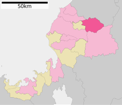 Location of Katsuyama in Fukui Prefecture | |
 Katsuyama | |
| Coordinates: 36°3′39.1″N 136°30′2.3″E | |
| Country | Japan |
| Region | Chūbu (Hokuriku) |
| Prefecture | Fukui |
| Town settled | April 1, 1889 |
| City settled | September 1, 1954 |
| Government | |
| • Mayor | Mikio Mizunami (from December 2020) |
| Area | |
| • Total | 253.88 km2 (98.02 sq mi) |
| Population (May 2018) | |
| • Total | 23,527 |
| • Density | 93/km2 (240/sq mi) |
| Time zone | UTC+9 (Japan Standard Time) |
| Phone number | 0779-88-1111 |
| Address | 1-1-1 Motomachi, Katsuyama-shi, Fukui-ken 911-8501 |
| Climate | Cfa |
| Website | www |
| Symbols | |
| Flower | Satsuki Azalea |
| Tree | Cryptomeria |

Geography
Katsuyama is located in the Katsuyama Basin of far northern Fukui Prefecture, bordered by Ishikawa Prefecture to the north, and surrounded by mountains on all sides. The Kuzuryū River flows through part of the city. Parts of the city are within the borders of Hakusan National Park.
Neighbouring municipalities
Climate
Katsuyama has a Humid climate (Köppen Cfa) characterized by warm, wet summers and cold winters with heavy snowfall. The average annual temperature in Katsuyama is 13.3 °C (55.9 °F). The average annual rainfall is 2,281.5 mm (89.82 in) with July as the wettest month. The temperatures are highest on average in August, at around 26.0 °C (78.8 °F), and lowest in January, at around 1.1 °C (34.0 °F).[3]
| Climate data for Katsuyama (1993−2020 normals, extremes 1993−present) | |||||||||||||
|---|---|---|---|---|---|---|---|---|---|---|---|---|---|
| Month | Jan | Feb | Mar | Apr | May | Jun | Jul | Aug | Sep | Oct | Nov | Dec | Year |
| Record high °C (°F) | 16.2 (61.2) |
17.3 (63.1) |
22.6 (72.7) |
29.4 (84.9) |
33.8 (92.8) |
34.7 (94.5) |
36.7 (98.1) |
36.8 (98.2) |
35.5 (95.9) |
29.7 (85.5) |
25.0 (77.0) |
22.0 (71.6) |
36.8 (98.2) |
| Average high °C (°F) | 4.6 (40.3) |
5.7 (42.3) |
10.5 (50.9) |
17.1 (62.8) |
22.5 (72.5) |
25.7 (78.3) |
29.3 (84.7) |
31.0 (87.8) |
26.8 (80.2) |
21.1 (70.0) |
14.6 (58.3) |
7.7 (45.9) |
18.1 (64.5) |
| Daily mean °C (°F) | 1.1 (34.0) |
1.6 (34.9) |
5.3 (41.5) |
11.5 (52.7) |
17.1 (62.8) |
20.9 (69.6) |
24.7 (76.5) |
26.0 (78.8) |
21.8 (71.2) |
15.7 (60.3) |
9.7 (49.5) |
3.8 (38.8) |
13.3 (55.9) |
| Average low °C (°F) | −1.7 (28.9) |
−1.9 (28.6) |
0.7 (33.3) |
6.1 (43.0) |
11.9 (53.4) |
16.8 (62.2) |
21.2 (70.2) |
22.0 (71.6) |
17.8 (64.0) |
11.4 (52.5) |
5.4 (41.7) |
0.6 (33.1) |
9.2 (48.5) |
| Record low °C (°F) | −9.1 (15.6) |
−9.8 (14.4) |
−6.9 (19.6) |
−2.9 (26.8) |
2.2 (36.0) |
8.9 (48.0) |
14.7 (58.5) |
14.0 (57.2) |
8.2 (46.8) |
1.9 (35.4) |
−1.7 (28.9) |
−8.0 (17.6) |
−9.8 (14.4) |
| Average precipitation mm (inches) | 224.5 (8.84) |
138.4 (5.45) |
154.2 (6.07) |
150.0 (5.91) |
159.7 (6.29) |
180.0 (7.09) |
291.4 (11.47) |
195.6 (7.70) |
195.0 (7.68) |
148.4 (5.84) |
180.0 (7.09) |
260.2 (10.24) |
2,281.5 (89.82) |
| Average precipitation days (≥ 1.0 mm) | 21.1 | 16.2 | 15.6 | 12.4 | 11.6 | 11.7 | 13.7 | 10.0 | 12.2 | 11.8 | 14.9 | 21.3 | 172.5 |
| Mean monthly sunshine hours | 67.1 | 89.3 | 125.0 | 163.8 | 185.5 | 142.2 | 141.8 | 191.2 | 141.1 | 149.1 | 114.9 | 74.6 | 1,585.6 |
| Source: Japan Meteorological Agency[4][3] | |||||||||||||
Demographics
Per Japanese census data,[5] the population of Katsuyama has been declining over the past 50 years.
| Year | Pop. | ±% |
|---|---|---|
| 1970 | 32,691 | — |
| 1980 | 30,852 | −5.6% |
| 1990 | 29,805 | −3.4% |
| 2000 | 28,143 | −5.6% |
| 2010 | 25,466 | −9.5% |
| 2020 | 22,150 | −13.0% |
History
Katsuyama is part of ancient Echizen Province. During the Edo period, the area was divided between the holdings of Echizen-Katsuyama Domain, Fukui Domain, Ōno Domain, and Gujō Domain. Following the Meiji restoration, it was organised into part of Ōno District in Fukui Prefecture. With the establishment of the modern municipalities system on April 1, 1889, the town of Katsuyama was established. It annexed the village of Inose on April 15, 1931, On September 1, 1954, Katsuyama merged with the villages of Arado, Muraoka, Kitago, Kitadani, Shikadani, Osoha, Heisen-ji and Nomuki to form the city of Katsuyama.
Government
Katsuyama has a mayor-council form of government with a directly elected mayor and a unicameral city legislature of 16 members.
Economy
The economy of Katsuyama is primarily agricultural.
Education
Katsuyama has nine public elementary schools and three middle schools operated by the city government, and one combined private elementary/middle school. The city has one public high school operated by the Fukui Prefectural Board of Education. The prefecture also operates one special education school.
Transportation
Railway
Highway
 Hokuriku Expressway
 National Route 416
 National Route 265
International relations
 - Aspen, Colorado, USA, friendship city
Local attractions


- Fukui Prefectural Dinosaur Museum
- Katsuyama Castle
- Heisenji Hakusan Jinja
Notable people from Katsuyama
- Unshō Ishizuka, voice actor
- Akane Yamaguchi, Japanese badminton player
References
- "Population of Katsuyama City" (in Japanese). Japan: Katsuyama City. Retrieved 8 July 2018.
- "Our Thinking, Insights, and Perspectives | Mercer".
- 気象庁 / 平年値(年・月ごとの値). JMA. Retrieved April 1, 2022.
- 観測史上1~10位の値(年間を通じての値). JMA. Retrieved April 1, 2022.
- Katsuyama population statistics
External links
 Media related to Katsuyama, Fukui at Wikimedia Commons
 Katsuyama travel guide from Wikivoyage
 Geographic data related to Katsuyama, Fukui at OpenStreetMap
- Katsuyama City official website (in Japanese)
- Katsuyama City official website (in English)
Fukui (capital) | ||
| Core city | ||
| Cities | ||
| Districts | ||
List of mergers in Fukui Prefecture | ||
Authority control | |
|---|---|
| General | |
| National libraries | |
| Other |
|
This Fukui Prefecture location article is a stub. You can help Wikipedia by expanding it. |
На других языках
[de] Katsuyama
Katsuyama (jap. .mw-parser-output .Hani{font-size:110%}勝山市, -shi) ist eine japanische Stadt in der Präfektur Fukui.- [en] Katsuyama, Fukui
[ru] Кацуяма
Кацуяма (яп. 勝山市 Кацуяма-си) — город в Японии, находящийся в префектуре Фукуи. Площадь города составляет 253,68 км²[1], население — 24 167 человек (1 июля 2014)[2], плотность населения — 95,27 чел./км².Другой контент может иметь иную лицензию. Перед использованием материалов сайта WikiSort.org внимательно изучите правила лицензирования конкретных элементов наполнения сайта.
WikiSort.org - проект по пересортировке и дополнению контента Википедии