world.wikisort.org - Italy
Porpetto (Friulian: Porpêt) is a comune (municipality) in the Province of Udine in the Italian region Friuli-Venezia Giulia, located about 50 kilometres (31 mi) northwest of Trieste and about 25 kilometres (16 mi) south of Udine. As of 31 December 2004, it had a population of 2,717 and an area of 19.7 square kilometres (7.6 sq mi).[3]
Porpetto | |
|---|---|
Comune | |
| Comune di Porpetto | |
Location of Porpetto  | |
 Porpetto Location of Porpetto in Italy  Porpetto Porpetto (Friuli-Venezia Giulia) | |
| Coordinates: 45°51′N 13°13′E | |
| Country | Italy |
| Region | Friuli-Venezia Giulia |
| Province | Province of Udine (UD) |
| Frazioni | Castello, Corgnolo, Pampaluna |
| Area | |
| • Total | 19.7 km2 (7.6 sq mi) |
| Elevation | 10 m (30 ft) |
| Population (Dec. 2004)[2] | |
| • Total | 2,717 |
| • Density | 140/km2 (360/sq mi) |
| Demonym(s) | Porpettesi |
| Time zone | UTC+1 (CET) |
| • Summer (DST) | UTC+2 (CEST) |
| Postal code | 33050 |
| Dialing code | 0431 |
| Website | Official website |
The municipality of Porpetto contains the frazioni (subdivisions, mainly villages and hamlets) Castello, Corgnolo, Foredana and Pampaluna. The river Corno crosses the city.
Porpetto borders the following municipalities: Castions di Strada, Gonars, San Giorgio di Nogaro, Torviscosa.
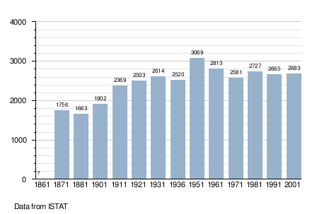
Demographic evolution
References
- "Superficie di Comuni Province e Regioni italiane al 9 ottobre 2011". Italian National Institute of Statistics. Retrieved 16 March 2019.
- "Popolazione Residente al 1° Gennaio 2018". Italian National Institute of Statistics. Retrieved 16 March 2019.
- All demographics and other statistics: Italian statistical institute Istat.
External links
Friuli Venezia Giulia · Comuni of the former Province of Udine | ||
|---|---|---|
|  | |
| Authority control |
|
|---|
This article on a location in Friuli Venezia Giulia is a stub. You can help Wikipedia by expanding it. |
На других языках
- [en] Porpetto
[ru] Порпетто
Порпетто (итал. Porpetto) — коммуна в Италии, располагается в регионе Фриули-Венеция-Джулия, в провинции Удине.Текст в блоке "Читать" взят с сайта "Википедия" и доступен по лицензии Creative Commons Attribution-ShareAlike; в отдельных случаях могут действовать дополнительные условия.
Другой контент может иметь иную лицензию. Перед использованием материалов сайта WikiSort.org внимательно изучите правила лицензирования конкретных элементов наполнения сайта.
Другой контент может иметь иную лицензию. Перед использованием материалов сайта WikiSort.org внимательно изучите правила лицензирования конкретных элементов наполнения сайта.
2019-2025
WikiSort.org - проект по пересортировке и дополнению контента Википедии
WikiSort.org - проект по пересортировке и дополнению контента Википедии