world.wikisort.org - Germany
Reinickendorf (German pronunciation: [ˈʁaɪnɪkn̩ˌdɔʁf] (![]() listen)) is a locality (Ortsteil) of Berlin in the borough (Bezirk) of Reinickendorf. It had a population of 83,972 in 2020.
listen)) is a locality (Ortsteil) of Berlin in the borough (Bezirk) of Reinickendorf. It had a population of 83,972 in 2020.
Reinickendorf | |
|---|---|
Quarter of Berlin | |
 Village church | |
Location of Reinickendorf in Reinickendorf district and Berlin 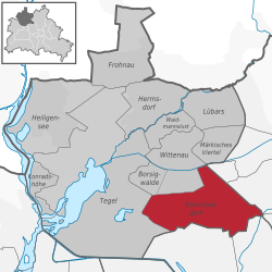 | |
 Reinickendorf  Reinickendorf | |
| Coordinates: 52°34′00″N 13°20′00″E | |
| Country | Germany |
| State | Berlin |
| City | Berlin |
| Borough | Reinickendorf |
| Founded | 1230 |
| Area | |
| • Total | 10.5 km2 (4.1 sq mi) |
| Elevation | 52 m (171 ft) |
| Population (2021-12-31)[1] | |
| • Total | 83,467 |
| • Density | 7,900/km2 (21,000/sq mi) |
| Time zone | UTC+01:00 (CET) |
| • Summer (DST) | UTC+02:00 (CEST) |
| Postal codes | (nr. 1201) 13403, 13407, 13409 |
| Vehicle registration | B |
Geography

The locality is situated in the south-western side of its district. It borders the localities of Tegel in the west, Wittenau and Borsigwalde in the north. To the east are Wilhelmsruh, Niederschönhausen and Pankow, all three in the Pankow borough, to the south Gesundbrunnen and Wedding, both in the borough of Mitte.
History
The name of the former Reinickendorf village can be traced back to a peasant Reinhardt (Reineke in Low German), who settled here around 1230. The locality was first mentioned in a 1345 deed and acquired by the City of Berlin in 1397. The late 19th century saw a significant increase in population, when Reinickendorf received direct access to Berlin with the opening of the Nordbahn railway line to Neustrelitz in 1877.
Reinickendorf was incorporated into the City of Berlin by the 1920 Greater Berlin Act. In 1928, architect Otto Rudolf Salvisberg designed the Weiße Stadt (White City), part of the Berlin Modernist Housing Estates, a UNESCO World Heritage Site.[2]
Transportation
Reinickendorf is served by the Berlin S-Bahn lines S1, S25, S85 and by the U-Bahn line U8. The S-Bahn stations are Schönholz, Wilhelmsruh,[3] Alt-Reinickendorf, Karl Bonhoeffer Nervenklinik and Eichborndamm. The U-Bahn stations are Rathaus Reinickendorf, Karl Bonhoeffer Nervenklinik, Lindauer Allee, Paracelsus Bad, Residenzstraße and Franz Neumann Platz.
Photogallery
 S-Bahn station Alt-Reinickendorf
 City hall
 Church


See also
- Berlin-Reinickendorf (electoral district)
- Berlin-Reinickendorf station
References
- "Einwohnerinnen und Einwohner im Land Berlin am 31. Dezember 2021" (PDF). Amt für Statistik Berlin-Brandenburg. February 2022.
- (in German) Historical infos about Reinickendorf
- Station located at the border between the localities of Reinickendorf and Wilhelmsruh
External links
![]() Media related to Berlin-Reinickendorf at Wikimedia Commons
Media related to Berlin-Reinickendorf at Wikimedia Commons
- (in German) Reinickendorf page of borough site
Boroughs and neighborhoods of Berlin | |
|---|---|
| |
Authority control | |
|---|---|
| General | |
| National libraries | |
На других языках
[de] Berlin-Reinickendorf
Reinickendorf ist ein Ortsteil im gleichnamigen Bezirk Reinickendorf von Berlin.- [en] Reinickendorf (locality)
[ru] Райниккендорф (район Берлина)
Райниккендорф (нем. Reinickendorf) — район в берлинском административном округе Райниккендорф, давшим ему своё название. Район граничит на юге с районом Веддинг (округ Митте), на востоке — с районами Нидершёнхаузен и Вильгельмсру (округ Панков), на севере — с районами Виттенау и Борсигвальде и на западе — с районом Тегель (округ Райниккендорф).Другой контент может иметь иную лицензию. Перед использованием материалов сайта WikiSort.org внимательно изучите правила лицензирования конкретных элементов наполнения сайта.
WikiSort.org - проект по пересортировке и дополнению контента Википедии