world.wikisort.org - France
Talasani (French pronunciation: [talazani]) is a commune in the Haute-Corse department of France on the island of Corsica.
This article may be expanded with text translated from the corresponding article in French. (December 2008) Click [show] for important translation instructions.
|
Talasani | |
|---|---|
Commune | |
Location of Talasani  | |
 Talasani  Talasani | |
| Coordinates: 42°24′32″N 9°28′50″E | |
| Country | France |
| Region | Corsica |
| Department | Haute-Corse |
| Arrondissement | Corte |
| Canton | Casinca-Fumalto |
| Intercommunality | Costa Verde |
| Government | |
| • Mayor (2020–2026) | Francis Marcantei[1] |
| Area 1 | 10.09 km2 (3.90 sq mi) |
| Population | 796 |
| • Density | 79/km2 (200/sq mi) |
| Time zone | UTC+01:00 (CET) |
| • Summer (DST) | UTC+02:00 (CEST) |
| INSEE/Postal code | 2B319 /20230 |
| Elevation | 0–487 m (0–1,598 ft) (avg. 392 m or 1,286 ft) |
| 1 French Land Register data, which excludes lakes, ponds, glaciers > 1 km2 (0.386 sq mi or 247 acres) and river estuaries. | |
Geography
Talasani is a village on the eastern coast of Corsica, part of the canton of Casinca-Fumalto. It was once part of the piève, or religious district, of Tavagna. Today, Talasani belongs to the Communauté de Communes de la Costa Verde of Costa Verde, a microregion north of the Plaine orientale.[3]
Town planning
This section may be a rough translation from French. It may have been generated, in whole or in part, by a computer or by a translator without dual proficiency. (December 2021) |
Typology
Talasani is a rural commune, because it is part of the commune with little to no population density, within the meaning of the municipal density grid of Insee.[note 1][4][5][6][7] It belongs to the urban unit of Penta-di-Casinca, an intra-departmental agglomeration comprising 7 communes and 9,501 inhabitants in 2017, of which it is a suburban municipality.[8][9]
In addition, the commune is part of the attraction area of Bastia, of which it is a municipality in the crown.[note 2] This area, which includes 93 communes, is categorized in areas of 50,000 to less than 200,000 inhabitants.[10][11]
The municipality, bordered by the Mediterranean Sea, is also a coastal municipality within the meaning of the law of January 3, 1986, known as the coastal law.[12] Specific urban planning provisions therefore apply in order to preserve natural spaces, sites, landscapes and the ecological balance of the coast, such as the principle of unbuildability, outside urbanized spaces, on the strip of the coastline of 100 meters, or more if the local urban plan provides for it.[13][14]
Land use
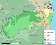
According to the European database of biophysical land use Corine Land Cover (CLC), Talasani's land use consists mostly of forests and semi-natural environments (75.5% in 2018), a proportion roughly equivalent to that of 1990 (75.4%). The detailed breakdown in 2018 is as follows: shrub and/or herbaceous vegetation (46.6%), forests (28.9%), heterogeneous agricultural areas (12.2%), urbanized areas (8.3%), permanent crops (3.9%), artificial green spaces, non-agricultural (0.1%), maritime waters (0.1%).[15]
IGN also provides an online tool to compare the evolution over time of land use in the municipality (or in territories at different scales). Several eras are accessible in the form of maps or aerial photos: the Cassini map (eighteenth century), the staff map (1820-1866) and the current period (1950 to today).[16]
Population
| Year | Pop. | ±% |
|---|---|---|
| 1800 | 422 | — |
| 1806 | 464 | +10.0% |
| 1821 | 453 | −2.4% |
| 1831 | 440 | −2.9% |
| 1836 | 480 | +9.1% |
| 1841 | 527 | +9.8% |
| 1846 | 541 | +2.7% |
| 1851 | 511 | −5.5% |
| 1856 | 524 | +2.5% |
| 1861 | 674 | +28.6% |
| 1866 | 483 | −28.3% |
| 1872 | 460 | −4.8% |
| 1876 | 443 | −3.7% |
| 1881 | 472 | +6.5% |
| 1886 | 445 | −5.7% |
| 1891 | 428 | −3.8% |
| 1896 | 443 | +3.5% |
| 1901 | 529 | +19.4% |
| 1906 | 515 | −2.6% |
| 1911 | 520 | +1.0% |
| 1921 | 390 | −25.0% |
| 1926 | 402 | +3.1% |
| 1931 | 444 | +10.4% |
| 1936 | 440 | −0.9% |
| 1946 | 271 | −38.4% |
| 1954 | 311 | +14.8% |
| 1962 | 263 | −15.4% |
| 1968 | 236 | −10.3% |
| 1975 | 226 | −4.2% |
| 1982 | 218 | −3.5% |
| 1990 | 394 | +80.7% |
| 1999 | 516 | +31.0% |
| 2006 | 567 | +9.9% |
Historical population data[17]
See also
Notes
- According to the zoning of rural and urban municipalities published in November 2020, in application of the new definition of rurality validated on November 14, 2020 by the interministerial committee of ruralities.
- In October 2020, the notion of city catchment area replaced the old notion of urban area, to allow consistent comparisons with other European Union countries.
References
- "Répertoire national des élus: les maires". data.gouv.fr, Plateforme ouverte des données publiques françaises (in French). 2 December 2020.
- "Populations légales 2019". The National Institute of Statistics and Economic Studies. 29 December 2021.
- "Site officiel de la Communauté de Communes de la Costa Verde" (in French). Retrieved 2021-11-27.
- "Typologie urbain / rural | L'Observatoire des Territoires". www.observatoire-des-territoires.gouv.fr. Retrieved 2021-12-24.
- "Définition - Commune rurale | Insee". www.insee.fr. Retrieved 2021-12-24.
- "Comprendre la grille de densité | L'Observatoire des Territoires". www.observatoire-des-territoires.gouv.fr. Retrieved 2021-12-24.
- "Unité urbaine 2020 de Penta-di-Casinca (2B203) − COG | Insee". www.insee.fr. Retrieved 2021-12-24.
- "Base des unités urbaines 2020 | Insee". www.insee.fr. Retrieved 2021-12-24.
- "Toujours plus d'habitants dans les unités urbaines - Insee Focus - 210". www.insee.fr. Retrieved 2021-12-24.
- "Aire d'attraction des villes 2020 de Bastia (104) − COG | Insee". www.insee.fr. Retrieved 2021-12-24.
- "En France, neuf personnes sur dix vivent dans l'aire d'attraction d'une ville - Insee Focus - 211". www.insee.fr. Retrieved 2021-12-24.
- "Les communes soumises à la loi littoral | L'Observatoire des Territoires". www.observatoire-des-territoires.gouv.fr. Retrieved 2021-12-24.
- "La loi littoral | Collectivités locales" [Coastal law | Local authorities] (in French). Archived from the original on 2021-04-13. Retrieved 24 December 2021.
- "Loi relative à l'aménagement, la protection et la mise en valeur du littoral". Ministère de la Cohésion des territoires et des Relations avec les collectivités territoriales (in French). Retrieved 2021-12-24.
- "CORINE Land Cover | Données et études statistiques". www.statistiques.developpement-durable.gouv.fr. Retrieved 2021-12-24.
- "Remonter le temps". remonterletemps.ign.fr. Retrieved 2021-12-24.
- "Talasani-Notice Communale" (in French). Retrieved 2021-11-27.
This Haute-Corse geographical article is a stub. You can help Wikipedia by expanding it. |
На других языках
[de] Talasani
Talasani ist eine französische Gemeinde im Département Haute-Corse auf der Insel Korsika. Sie gehört zum Kanton Casinca-Fiumalto im Arrondissement Corte.- [en] Talasani
[es] Talasani
Talasani es una comuna y población de Francia, en la región de Córcega, departamento de Alta Córcega.[ru] Талазани
Талазани (фр. Talasani, корс. Talasani) — коммуна во Франции, находится в регионе Корсика. Департамент коммуны — Верхняя Корсика. Входит в состав кантона Казинка-Фумальто. Округ коммуны — Бастия.Другой контент может иметь иную лицензию. Перед использованием материалов сайта WikiSort.org внимательно изучите правила лицензирования конкретных элементов наполнения сайта.
WikiSort.org - проект по пересортировке и дополнению контента Википедии