world.wikisort.org - France
La Rochepot (French pronunciation: [la ʁɔʃpo]) is a commune in France in Bourgogne-Franche-Comté, Côte-d'Or department. It is a part of the canton of Arnay-le-Duc and of the arrondissement of Beaune. It has a hillside castle, converted to a château, on the D973 road between Beaune and Nolay on the way to Saisy.
This article may be expanded with text translated from the corresponding article in French. (January 2009) Click [show] for important translation instructions.
|
La Rochepot | |
|---|---|
Commune | |
 A general view of La Rochepot | |
 Coat of arms | |
Location of La Rochepot  | |
 La Rochepot  La Rochepot | |
| Coordinates: 46°57′32″N 4°40′47″E | |
| Country | France |
| Region | Bourgogne-Franche-Comté |
| Department | Côte-d'Or |
| Arrondissement | Beaune |
| Canton | Arnay-le-Duc |
| Intercommunality | Beaune Côte et Sud |
| Government | |
| • Mayor (2020–2026) | Véronique Richer[1] |
| Area 1 | 13.91 km2 (5.37 sq mi) |
| Population | 285 |
| • Density | 20/km2 (53/sq mi) |
| Time zone | UTC+01:00 (CET) |
| • Summer (DST) | UTC+02:00 (CEST) |
| INSEE/Postal code | 21527 /21340 |
| Elevation | 324–561 m (1,063–1,841 ft) |
| 1 French Land Register data, which excludes lakes, ponds, glaciers > 1 km2 (0.386 sq mi or 247 acres) and river estuaries. | |
The INSEE code is 21527.
History
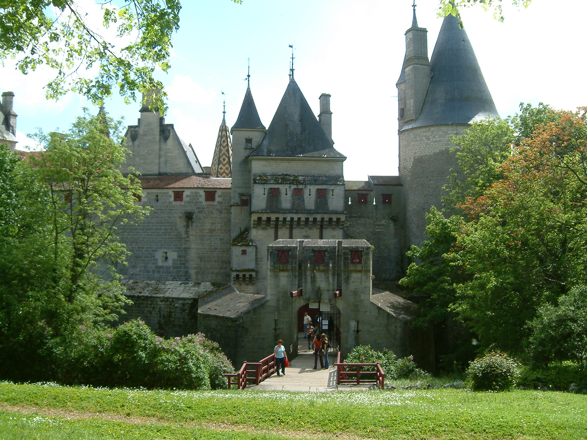
La Rochepot is known for its castle, the Château de la Rochepot. The earliest record of the castle dates back to 1180 when it was called "Château de La Roche Nolay". In 1403, the castle was bought by Regnier Pot, a knight, who renamed it.
The commune of La Rochepot is famous for its winemaking traditions. The primary cultivated grape varieties are Pinot Noir and Chardonnay.[3]
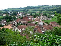 La Rochepot
 The château
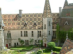 The château
 The château roof
 The château
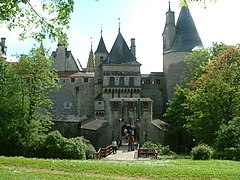 The château
 Vines
Vines


Geography
Climate
La Rochepot has a oceanic climate (Köppen climate classification Cfb). The average annual temperature in La Rochepot is 10.2 °C (50.4 °F). The average annual rainfall is 837.3 mm (32.96 in) with May as the wettest month. The temperatures are highest on average in July, at around 19.3 °C (66.7 °F), and lowest in January, at around 1.6 °C (34.9 °F). The highest temperature ever recorded in La Rochepot was 39.0 °C (102.2 °F) on 12 August 2003; the coldest temperature ever recorded was −21.0 °C (−5.8 °F) on 9 January 1985.
| Climate data for La Rochepot (1981–2010 averages, extremes 1949−present) | |||||||||||||
|---|---|---|---|---|---|---|---|---|---|---|---|---|---|
| Month | Jan | Feb | Mar | Apr | May | Jun | Jul | Aug | Sep | Oct | Nov | Dec | Year |
| Record high °C (°F) | 14.5 (58.1) |
20.4 (68.7) |
23.8 (74.8) |
28.5 (83.3) |
32.0 (89.6) |
36.2 (97.2) |
38.0 (100.4) |
39.0 (102.2) |
34.0 (93.2) |
28.5 (83.3) |
21.1 (70.0) |
17.5 (63.5) |
39.0 (102.2) |
| Average high °C (°F) | 4.4 (39.9) |
6.2 (43.2) |
10.8 (51.4) |
14.4 (57.9) |
18.9 (66.0) |
22.5 (72.5) |
25.2 (77.4) |
24.6 (76.3) |
20.1 (68.2) |
14.8 (58.6) |
8.5 (47.3) |
5.1 (41.2) |
14.7 (58.5) |
| Daily mean °C (°F) | 1.6 (34.9) |
2.6 (36.7) |
6.3 (43.3) |
9.2 (48.6) |
13.5 (56.3) |
16.8 (62.2) |
19.3 (66.7) |
18.8 (65.8) |
14.9 (58.8) |
10.7 (51.3) |
5.3 (41.5) |
2.4 (36.3) |
10.2 (50.4) |
| Average low °C (°F) | −1.3 (29.7) |
−1.0 (30.2) |
1.7 (35.1) |
4.0 (39.2) |
8.2 (46.8) |
11.2 (52.2) |
13.3 (55.9) |
13.0 (55.4) |
9.7 (49.5) |
6.6 (43.9) |
2.1 (35.8) |
−0.3 (31.5) |
5.6 (42.1) |
| Record low °C (°F) | −21.0 (−5.8) |
−20.0 (−4.0) |
−14.5 (5.9) |
−5.5 (22.1) |
−3.0 (26.6) |
1.5 (34.7) |
4.0 (39.2) |
0.0 (32.0) |
0.0 (32.0) |
−6.0 (21.2) |
−11.0 (12.2) |
−18.0 (−0.4) |
−21.0 (−5.8) |
| Average precipitation mm (inches) | 67.6 (2.66) |
56.2 (2.21) |
55.1 (2.17) |
68.2 (2.69) |
82.9 (3.26) |
72.5 (2.85) |
65.9 (2.59) |
59.6 (2.35) |
71.3 (2.81) |
81.3 (3.20) |
81.9 (3.22) |
74.8 (2.94) |
837.3 (32.96) |
| Average precipitation days (≥ 1.0 mm) | 11.9 | 10.5 | 10.4 | 10.6 | 11.5 | 8.7 | 7.4 | 8.3 | 8.4 | 11.0 | 12.1 | 12.2 | 123.1 |
| Source: Meteociel[4] | |||||||||||||
Population
The population of the commune in 2017 was 291.
| Year | Pop. | ±% |
|---|---|---|
| 1968 | 275 | — |
| 1975 | 258 | −6.2% |
| 1982 | 272 | +5.4% |
| 1990 | 241 | −11.4% |
| 1999 | 260 | +7.9% |
| 2007 | 281 | +8.1% |
| 2012 | 289 | +2.8% |
| 2017 | 291 | +0.7% |
| Source: INSEE[5] | ||
Economy
In 2010, of 171 persons of working age (15–64 years old), 120 were regarded as economically active; the economic activity rate was 70,2% compared to 71.9% in 1999. Of the 120 active persons, 115 persons (65 men and 50 women) had a job, five were jobless (3 men and 2 women). Of the 51 economically inactive persons, 14 persons were schoolchildren and students, 24 were retired and 13 were inactive for other reasons.[6]
See also
- Communes of the Côte-d'Or department
- List of arrondissements of France
References
- "Répertoire national des élus: les maires" (in French). data.gouv.fr, Plateforme ouverte des données publiques françaises. 13 September 2022.
- "Populations légales 2019". The National Institute of Statistics and Economic Studies. 29 December 2021.
- Thorsten Droste (1998). Burgund: Klšster, Schlšsser, historische StŠdte und die Kultur des Weinbaus im Herzen Frankreichs (in German). DuMont Reiseverlag, 1998. ISBN 9783770141661.
- "Normales et records pour La Rochepot (21)". Meteociel. Retrieved 18 June 2022.
- Population en historique depuis 1968, INSEE
- "Base chiffres clés: emploi — population active 2010" (in French). INSEE. Retrieved 2014-08-29. (crude data, in 1999 temporary employment was partially registered)
External links
| |||||
|
| Metropolitan regions |
|
|---|---|
| Overseas regions | |
World Heritage Sites in France | ||
|---|---|---|
| Île-de-France |
| |
| Parisian basin |
| |
| Nord-Pas-de-Calais |
| |
| East |
| |
| West |
| |
| South West |
| |
| Centre East |
| |
| Mediterranean |
| |
| Multiple regions |
| |
| Overseas departments and territories |
| |
| ||
Authority control | |
|---|---|
| General |
|
| National libraries | |
This Côte-d'Or geographical article is a stub. You can help Wikipedia by expanding it. |
На других языках
[de] La Rochepot
La Rochepot ist eine französische Gemeinde mit 285 Einwohnern (Stand 1. Januar 2019) im Département Côte-d’Or in der Region Bourgogne-Franche-Comté; sie gehört zum Arrondissement Beaune und zum Kanton Arnay-le-Duc. Der Ort hieß früher La Roche-Nolay. Hier entspringt das Flüsschen Cloux.- [en] La Rochepot
[ru] Ла-Рошпо
Ла-Рошпо́ (фр. La Rochepot) — коммуна во Франции, находится в регионе Бургундия. Департамент коммуны — Кот-д’Ор. Входит в состав кантона Арне-ле-Дюк. Округ коммуны — Бон.Другой контент может иметь иную лицензию. Перед использованием материалов сайта WikiSort.org внимательно изучите правила лицензирования конкретных элементов наполнения сайта.
WikiSort.org - проект по пересортировке и дополнению контента Википедии