world.wikisort.org - France
Crécy-la-Chapelle (French pronunciation: [kʁesi la ʃapɛl] (![]() listen)) is a commune in the Seine-et-Marne department in the Île-de-France region in north-central France.
listen)) is a commune in the Seine-et-Marne department in the Île-de-France region in north-central France.
Crécy-la-Chapelle | |
|---|---|
Commune | |
 The town hall in Crécy-la-Chapelle | |
 Coat of arms | |
Location of Crécy-la-Chapelle  | |
 Crécy-la-Chapelle  Crécy-la-Chapelle | |
| Coordinates: 48°51′23″N 2°54′40″E | |
| Country | France |
| Region | Île-de-France |
| Department | Seine-et-Marne |
| Arrondissement | Meaux |
| Canton | Serris |
| Intercommunality | CA Coulommiers Pays de Brie |
| Government | |
| • Mayor (2020–2026) | Bernard Carouge[1] |
| Area 1 | 15.78 km2 (6.09 sq mi) |
| Population | 4,713 |
| • Density | 300/km2 (770/sq mi) |
| Time zone | UTC+01:00 (CET) |
| • Summer (DST) | UTC+02:00 (CEST) |
| INSEE/Postal code | 77142 /77580 |
| Elevation | 45–157 m (148–515 ft) |
| 1 French Land Register data, which excludes lakes, ponds, glaciers > 1 km2 (0.386 sq mi or 247 acres) and river estuaries. | |
Geography
Crécy-la-Chapelle is crossed by the river Grand Morin. The ground of the area is limestone. Crécy-la-Chapelle station has rail connections to Chelles and Paris.
Localities within the commune are Crécy Bourg, Montbarbin, Serbonne, la Chapelle-sur-Crécy, Libernon, Mongrolle, Férolles, Montaudier, la Grand-Cour, les Hauts-Soleil, le Choisiel, le Souterain, Montpichet.
Demographics
The inhabitants are called Créçois.
Politics and administration
The town is twinned with
Pielenhofen ![]()
Local culture and heritage

Spots and monuments
- Collegiale Notre-Dame de Crécy-la-Chapelle,[3] classified monument historique since 1846.[4]
- Saint-Georges church.
- Beffroi.
- Quai des Tanneries.
- Tour aux Saints.
- War memorial for WW1 (Edme Marie Cadoux).
- The local museum is Musée de France, au sens de la loi No. 2002-5 du 4 January 2002 ; It is closed now (January 2013).
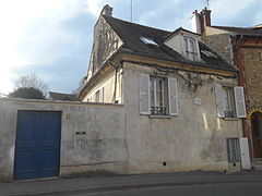 House where lived the artist Corot.
 Wall walk.
 Belfry dating from the 19th century built on a tower dating from 12th century.
 War memorial.
 Vestige of the delivery service.


See also
References
- "Répertoire national des élus: les maires" (in French). data.gouv.fr, Plateforme ouverte des données publiques françaises. 13 September 2022.
- "Populations légales 2019". The National Institute of Statistics and Economic Studies. 29 December 2021.
- La collégiale Notre-Dame-de-l’Assomption Archived 2016-12-03 at the Wayback Machine on the official website of the cityhall. Consulté le 10 octobre 2011.
- Base Mérimée: PA00086915, Ministère français de la Culture. (in French)
External links
Wikimedia Commons has media related to Crécy-la-Chapelle.
- 1999 Land Use, from IAURIF (Institute for Urban Planning and Development of the Paris-Île-de-France région) (in English)
- Base Mérimée: Search for heritage in the commune, Ministère français de la Culture. (in French)
- Official website of the city (in French)
Authority control | |
|---|---|
| General | |
| National libraries | |
| Other |
|
This article related to a Seine-et-Marne location is a stub. You can help Wikipedia by expanding it. |
На других языках
[de] Crécy-la-Chapelle
Vorlage:Infobox Gemeinde in Frankreich/Wartung/abweichendes Wappen in Wikidata- [en] Crécy-la-Chapelle
[fr] Crécy-la-Chapelle
Crécy-la-Chapelle est une commune française située dans le département de Seine-et-Marne en région Île-de-France.[ru] Креси-ла-Шапель
Креси́-ла-Шапе́ль (фр. Crécy-la-Chapelle) — коммуна во Франции, находится в регионе Иль-де-Франс. Департамент — Сена и Марна. Входит в состав кантона Серрис. Округ коммуны — Мо.Текст в блоке "Читать" взят с сайта "Википедия" и доступен по лицензии Creative Commons Attribution-ShareAlike; в отдельных случаях могут действовать дополнительные условия.
Другой контент может иметь иную лицензию. Перед использованием материалов сайта WikiSort.org внимательно изучите правила лицензирования конкретных элементов наполнения сайта.
Другой контент может иметь иную лицензию. Перед использованием материалов сайта WikiSort.org внимательно изучите правила лицензирования конкретных элементов наполнения сайта.
2019-2026
WikiSort.org - проект по пересортировке и дополнению контента Википедии
WikiSort.org - проект по пересортировке и дополнению контента Википедии