world.wikisort.org - Brazil
Jaraguari is a municipality located in the Brazilian state of Mato Grosso do Sul. Its population was 7,342 (2021) and its area is 2,913 km².
Jaraguari | |
|---|---|
Municipality | |
 Flag | |
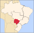
 Location in Mato Grosso do Sul state | |
 Jaraguari Location in Brazil | |
| Coordinates: 20°08′31″S 54°23′56″W | |
| Country | Brazil |
| Region | Central-West |
| State | Mato Grosso do Sul |
| Area | |
| • Total | 2,913 km2 (1,125 sq mi) |
| Population (2021[1]) | |
| • Total | 7,342 |
| • Density | 2.5/km2 (6.5/sq mi) |
| Time zone | UTC−4 (AMT) |
History
It was first settled by Brazilians in 1875 when Porfirio Alberto de Freitas, his wife, and his brother in-law settled into Jaraguari Velho (then called Fazenda Estiva). In January of 1909, José Thomaz Barbosa would draw up the borders of the municipality. Later, de Freitas ordered the construction of a church. It was only completed in 1923. It had been named Senhor Divino Espírito Santo, and was destroyed in 1930. After that, Japanese settlers arrived and created a separate community. In 1953, Jaraguari was made a municipality. The name was derived from Araguari, the old hometown of de Freitas. A J was added because Jaragua means grass in Brazilian Portuguese.[2]
Deforestation
Jaraguari is largely covered by forests, but has suffered 1.5% forest lost in the past 20 years, with much of this picking up pace in the 2010s.[3]
References
- IBGE 2021
- "DADOS HISTÓRICOS DO MUNICÍPIO". Jaraguari Prefeiturea. Retrieved 17 October 2021.
- "Jaraguari, Mato Grosso Do Sul, Brazil Deforestation Rates & Statistics". Global Forest Watch. Retrieved 17 October 2021.
Capital: Campo Grande | |||||||||
| Mesoregion Centro Norte de Mato Grosso do Sul |
|  | |||||||
| Mesoregion Leste de Mato Grosso do Sul |
| ||||||||
| Mesoregion Pantanal Sul Mato-Grossense |
| ||||||||
| Mesoregion Sudoeste de Mato Grosso do Sul |
| ||||||||
This Mato Grosso do Sul, Brazil location article is a stub. You can help Wikipedia by expanding it. |
На других языках
[de] Jaraguari
Jaraguari, amtlich portugiesisch Município de Jaraguari, ist eine Stadt im brasilianischen Bundesstaat Mato Grosso do Sul.- [en] Jaraguari
[ru] Жарагуари
Жарагуари (порт. Jaraguari) — муниципалитет в Бразилии, входит в штат Мату-Гросу-ду-Сул. Составная часть мезорегиона Северо-центральная часть штата Мату-Гроссу-ду-Сул. Входит в экономико-статистический микрорегион Кампу-Гранди. Население составляет 6049 человек на 2006 год. Занимает площадь 2 913,000 км². Плотность населения — 2,1 чел./км².Другой контент может иметь иную лицензию. Перед использованием материалов сайта WikiSort.org внимательно изучите правила лицензирования конкретных элементов наполнения сайта.
WikiSort.org - проект по пересортировке и дополнению контента Википедии