world.wikisort.org - Stati_Uniti_d'America
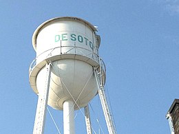
De Soto è un comune degli Stati Uniti d'America, situato nello Stato del Kansas, diviso tra la contea di Johnson e la contea di Leavenworth.
| De Soto city | |
|---|---|
| (EN) De Soto, Kansas | |
 | |
| Localizzazione | |
| Stato | |
| Stato federato | |
| Contea | Johnson |
| Territorio | |
| Coordinate | 38°57′54″N 94°57′43.92″W |
| Altitudine | 262 m s.l.m. |
| Superficie | 29,01 km² |
| Abitanti | 5 720 (2010) |
| Densità | 197,17 ab./km² |
| Altre informazioni | |
| Cod. postale | 66018–66019 e 66018 |
| Prefisso | 913 |
| Fuso orario | UTC-6 |
| Cartografia | |
 | |
| Sito istituzionale | |
Altri progetti
 Wikimedia Commons contiene immagini o altri file su De Soto
Collegamenti esterni
- (EN) Sito ufficiale, su desotoks.us.
- (EN) De Soto (insediamento umano) / De Soto (divisione amministrativa), su Geographic Names Information System, USGS.
На других языках
[en] De Soto, Kansas
De Soto /dəˈsoʊtoʊ/ is a city in Johnson and Leavenworth counties in the U.S. state of Kansas,[1] and part of the Kansas City Metropolitan Area. As of the 2020 census, the population of the city was 6,118.[3] De Soto was incorporated as a city on October 1, 1897.[fr] De Soto (Kansas)
La ville américaine de De Soto est située dans les comtés de Johnson et Leavenworth, dans l’État du Kansas, sur la rivière Kansas. Sa population était de 4 561 habitants lors du recensement de 2000. Coordonnées géographiques : 38° 57′ 54″ N, 94° 57′ 44″ O.- [it] De Soto (Kansas)
Текст в блоке "Читать" взят с сайта "Википедия" и доступен по лицензии Creative Commons Attribution-ShareAlike; в отдельных случаях могут действовать дополнительные условия.
Другой контент может иметь иную лицензию. Перед использованием материалов сайта WikiSort.org внимательно изучите правила лицензирования конкретных элементов наполнения сайта.
Другой контент может иметь иную лицензию. Перед использованием материалов сайта WikiSort.org внимательно изучите правила лицензирования конкретных элементов наполнения сайта.
2019-2025
WikiSort.org - проект по пересортировке и дополнению контента Википедии
WikiSort.org - проект по пересортировке и дополнению контента Википедии
