world.wikisort.org - Etats-Unis
La ville de Goodland est le siège du comté de Sherman, situé dans le Kansas, aux États-Unis.
Pour les articles homonymes, voir Goodland.
Cet article est une ébauche concernant une localité du Kansas.
Vous pouvez partager vos connaissances en l’améliorant (comment ?) selon les recommandations des projets correspondants.
| Goodland | ||||
| ||||
| Administration | ||||
|---|---|---|---|---|
| Pays | ||||
| État | ||||
| Comté | Sherman | |||
| Type de localité | City | |||
| Maire | Brian Linin | |||
| Code ZIP | 67735 | |||
| Code FIPS | 20-26875 | |||
| GNIS | 0471241 | |||
| Indicatif(s) téléphonique(s) local (locaux) | 785 | |||
| Démographie | ||||
| Population | 4 489 hab. (2010) | |||
| Densité | 397 hab./km2 | |||
| Géographie | ||||
| Coordonnées | 39° 20′ 55″ nord, 101° 42′ 40″ ouest | |||
| Altitude | 1 122 m |
|||
| Superficie | 1 132 ha = 11,32 km2 | |||
| · dont terre | 11,29 km2 (99,73 %) | |||
| · dont eau | 0,03 km2 (0,27 %) | |||
| Fuseau horaire | CST (UTC-6) | |||
| Divers | ||||
| Municipalité depuis | 1887 | |||
| Surnom | The Golden Buckle on the Wheat Belt | |||
| Localisation | ||||
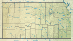
 Carte du comté de Sherman. | ||||
| Géolocalisation sur la carte : États-Unis
Géolocalisation sur la carte : États-Unis
Géolocalisation sur la carte : Kansas
| ||||
| Liens | ||||
| Site web | http://www.goodlandks.us | |||
| modifier |
||||


Source
- (en) Cet article est partiellement ou en totalité issu de l’article de Wikipédia en anglais intitulé « Goodland, Kansas » (voir la liste des auteurs).
 Portail du Kansas
На других языках
[en] Goodland, Kansas
Goodland is a city in and the county seat of Sherman County, Kansas, United States.[1] As of the 2020 census, the population of the city was 4,465.[3] It was named after Goodland, Indiana.[4] Goodland is home to Northwest Kansas Technical College.- [fr] Goodland (Kansas)
Текст в блоке "Читать" взят с сайта "Википедия" и доступен по лицензии Creative Commons Attribution-ShareAlike; в отдельных случаях могут действовать дополнительные условия.
Другой контент может иметь иную лицензию. Перед использованием материалов сайта WikiSort.org внимательно изучите правила лицензирования конкретных элементов наполнения сайта.
Другой контент может иметь иную лицензию. Перед использованием материалов сайта WikiSort.org внимательно изучите правила лицензирования конкретных элементов наполнения сайта.
2019-2025
WikiSort.org - проект по пересортировке и дополнению контента Википедии
WikiSort.org - проект по пересортировке и дополнению контента Википедии