world.wikisort.org - Etats-Unis
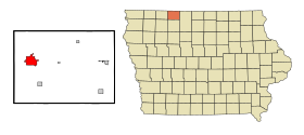
La ville américaine d’Estherville est le siège du comté d’Emmet, dans l’État de l’Iowa. Elle comptait 6 360 habitants lors du recensement de 2010.
| Estherville | ||||

| ||||
| Administration | ||||
|---|---|---|---|---|
| Pays | ||||
| État | ||||
| Comté | Emmet | |||
| Type de localité | City | |||
| Code FIPS | 19-25860 | |||
| GNIS | 0456397 | |||
| Démographie | ||||
| Population | 6 360 hab. (2010) | |||
| Densité | 471 hab./km2 | |||
| Géographie | ||||
| Coordonnées | 43° 24′ 16″ nord, 94° 50′ 01″ ouest | |||
| Altitude | 395 m |
|||
| Superficie | 1 350 ha = 13,5 km2 | |||
| · dont terre | 13,5 km2 (100 %) | |||
| · dont eau | 0 km2 (0 %) | |||
| Fuseau horaire | CST (UTC-6) | |||
| Localisation | ||||
 Carte du comté d'Emmet. | ||||
| Géolocalisation sur la carte : Iowa
Géolocalisation sur la carte : États-Unis
Géolocalisation sur la carte : États-Unis
| ||||
| Liens | ||||
| Site web | www.cityofestherville.org | |||
| modifier |
||||
Source
- (en) Cet article est partiellement ou en totalité issu de l’article de Wikipédia en anglais intitulé « Estherville, Iowa » (voir la liste des auteurs).
- Portail de l’Iowa
На других языках
[de] Estherville
Estherville ist eine Kleinstadt (mit dem Status "City") und Verwaltungssitz des Emmet County im Norden des US-amerikanischen Bundesstaates Iowa. Bei der Volkszählung im Jahr 2010 hatte Estherville 6360 Einwohner.[1][en] Estherville, Iowa
Estherville is a city in Emmet County, Iowa, United States. The population was 5,904 in the 2020 census, a decline from 6,656 at the 2000 census.[2] It is the county seat of Emmet County.[3]- [fr] Estherville
Текст в блоке "Читать" взят с сайта "Википедия" и доступен по лицензии Creative Commons Attribution-ShareAlike; в отдельных случаях могут действовать дополнительные условия.
Другой контент может иметь иную лицензию. Перед использованием материалов сайта WikiSort.org внимательно изучите правила лицензирования конкретных элементов наполнения сайта.
Другой контент может иметь иную лицензию. Перед использованием материалов сайта WikiSort.org внимательно изучите правила лицензирования конкретных элементов наполнения сайта.
2019-2025
WikiSort.org - проект по пересортировке и дополнению контента Википедии
WikiSort.org - проект по пересортировке и дополнению контента Википедии


