world.wikisort.org - Etats-Unis
Ashland (anciennement dénommée San Leandro South) est une census-designated place (CDP) américaine située dans le comté d'Alameda, en Californie. Elle compte 21 925 habitants en 2010[1].
Pour les articles homonymes, voir Ashland.
| Ashland | ||||
| Administration | ||||
|---|---|---|---|---|
| Pays | ||||
| État | ||||
| Comté | Alameda | |||
| Type de localité | Census-designated place (CDP) | |||
| Code FIPS | 06-02980 | |||
| GNIS | 1657955, 2407773 | |||
| Indicatif(s) téléphonique(s) local (locaux) | 510 | |||
| Démographie | ||||
| Population | 21 925 hab. (2010) | |||
| Densité | 4 605 hab./km2 | |||
| Géographie | ||||
| Coordonnées | 37° 41′ 41″ nord, 122° 06′ 50″ ouest | |||
| Altitude | 13 m |
|||
| Superficie | 476,1 ha = 4,761 km2 | |||
| · dont terre | 4,761 km2 (100 %) | |||
| · dont eau | 0 km2 (0 %) | |||
| Fuseau horaire | PST (UTC-8) | |||
| Localisation | ||||
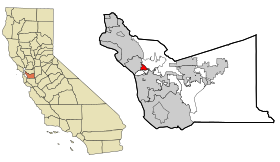 Carte du comté d'Alameda. | ||||
| Géolocalisation sur la carte : États-Unis
Géolocalisation sur la carte : États-Unis
Géolocalisation sur la carte : Californie
| ||||
| modifier |
||||


Histoire
La localité se développe dans les années 1940[2]. Ashland est nommée d'après le nom anglais du frêne de l'Oregon, « Oregon ash »[2].
Géographie

D'après le Bureau de recensement des États-Unis, le territoire de la CDP s'étend sur 4,7 km2 et est intégralement constitué de terre[1]. Située à environ 6,5 km de la rive est de la baie de San Francisco, Ashland se trouve à une altitude de 13 m[3].
Climat
La région connaît des étés doux et secs. D'après la classification de Köppen, le climat de Ashland est de type supra-méditerranéen (Csb).
Démographie

Administration
Ashland étant une communauté non incorporée, elle est directement administrée par le comté d'Alameda. La sécurité policière de la région est assurée par le Sheriff's Office du comté d'Alameda (en) et par la California Highway Patrol.
Notes et références
- (en) Cet article est partiellement ou en totalité issu de l’article de Wikipédia en anglais intitulé « Ashland, California » (voir la liste des auteurs).
- (en) Données du recensement de 2010 à Ashland
- (en) David L. Durham, California's Geographic Names: A Gazetteer of Historic and Modern Names of the State, Clovis (Californie), Word Dancer Press, , p. 597
- (en) Ashland, Geographic Names Information System, Institut d'études géologiques des États-Unis
- « Statistiques des États-Unis (Arizona) - Profils des communautés de 2010 » (consulté en )
Liens externes
 Portail de la région de la baie de San Francisco
На других языках
[de] Ashland (Kalifornien)
Ashland (früher auch San Leandro South[1]) ist ein Siedlungsgebiet (Census-designated place) im Südosten von San Leandro im Alameda County im US-Bundesstaat Kalifornien, Vereinigte Staaten, mit 21.925 Einwohnern (Stand: 2010).[en] Ashland, California
Ashland is a census-designated place (CDP) and unincorporated community[6] in Alameda County, California, United States. The population was 23,823 at the 2020 census.[7] Ashland is located between the city of San Leandro to the north, the unincorporated community of Cherryland to the south, the unincorporated community of Castro Valley to the east, and the unincorporated community of San Lorenzo to the southwest.- [fr] Ashland (Californie)
[ru] Ашленд (Калифорния)
Эшленд (англ. Ashland, прежде San Leandro South) — статистически обособленная местность, расположенная в округе Аламида (штат Калифорния, США) с населением в 20 793 человека по статистическим данным переписи 2000 года.Другой контент может иметь иную лицензию. Перед использованием материалов сайта WikiSort.org внимательно изучите правила лицензирования конкретных элементов наполнения сайта.
WikiSort.org - проект по пересортировке и дополнению контента Википедии