world.wikisort.org - USA
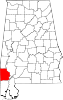
Sims Chapel (also Darrah, Grandfield) is a census-designated place and unincorporated community in Washington County, Alabama, United States. Its population was 153 as of the 2010 census.[3]
Sims Chapel, Alabama | |
|---|---|
Census-designated place | |
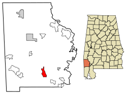 Location of Sims Chapel in Washington County, Alabama. | |
 Sims Chapel, Alabama | |
| Coordinates: 31°13′11″N 88°08′55″W | |
| Country | United States |
| State | Alabama |
| County | Washington |
| Area | |
| • Total | 5.73 sq mi (14.85 km2) |
| • Land | 5.70 sq mi (14.77 km2) |
| • Water | 0.03 sq mi (0.08 km2) |
| Elevation | 85 ft (26 m) |
| Population (2020) | |
| • Total | 145 |
| • Density | 25.43/sq mi (9.82/km2) |
| Time zone | UTC-6 (Central (CST)) |
| • Summer (DST) | UTC-5 (CDT) |
| Area code(s) | 251 |
| GNIS feature ID | 155628[2] |
Demographics
| Historical population | |||
|---|---|---|---|
| Census | Pop. | %± | |
| 2020 | 145 | — | |
| U.S. Decennial Census[4] | |||
References
- "2020 U.S. Gazetteer Files". United States Census Bureau. Retrieved October 29, 2021.
- "Sims Chapel". Geographic Names Information System. United States Geological Survey.
- "U.S. Census website". United States Census Bureau. Retrieved 2011-05-14.
- "Census of Population and Housing". Census.gov. Retrieved June 4, 2016.
Municipalities and communities of Washington County, Alabama, United States | ||
|---|---|---|
County seat: Chatom | ||
| Towns |
|  |
| CDPs |
| |
| Unincorporated communities |
| |
| Ghost towns |
| |
| Indian reservation |
| |
| Footnotes | ‡This populated place also has portions in an adjacent county or counties | |
| ||
This Washington County, Alabama state location article is a stub. You can help Wikipedia by expanding it. |
Текст в блоке "Читать" взят с сайта "Википедия" и доступен по лицензии Creative Commons Attribution-ShareAlike; в отдельных случаях могут действовать дополнительные условия.
Другой контент может иметь иную лицензию. Перед использованием материалов сайта WikiSort.org внимательно изучите правила лицензирования конкретных элементов наполнения сайта.
Другой контент может иметь иную лицензию. Перед использованием материалов сайта WikiSort.org внимательно изучите правила лицензирования конкретных элементов наполнения сайта.
2019-2026
WikiSort.org - проект по пересортировке и дополнению контента Википедии
WikiSort.org - проект по пересортировке и дополнению контента Википедии