world.wikisort.org - USA
Sibleyville is an unincorporated community in Douglas County, Kansas, United States. It is located five miles southeast of Lawrence. It was at the intersection of County Road 458 and the Leavenworth, Lawrence and Fort Gibson railroad tracks although the town never had more than a dozen houses.[2] Little remained of the town by the 1960s.[3]
Sibleyville, Kansas | |
|---|---|
Unincorporated community | |
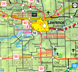 KDOT map of Douglas County (legend) | |
 Sibleyville  Sibleyville | |
| Coordinates: 38°53′03″N 95°11′44″W | |
| Country | United States |
| State | Kansas |
| County | Douglas |
| Elevation | 823 ft (251 m) |
| Time zone | UTC-6 (CST) |
| • Summer (DST) | UTC-5 (CDT) |
| Area code | 785 |
| GNIS ID | 484876 [1] |
References
- "US Board on Geographic Names". United States Geological Survey. 2007-10-25. Retrieved 2008-01-31.
- Kaw Valley Landscapes by James R. Shortridge. University Press of Kansas, 1977, 1988 pg. 190
- Cleland, Nora (Jun 12, 1961). "Only few of 45 county settlements left". Lawrence Journal-World. pp. 13A. Retrieved 1 November 2015.
Further reading
External links
Municipalities and communities of Douglas County, Kansas, United States | ||
|---|---|---|
County seat: Lawrence | ||
| Cities |  | |
| Unincorporated communities |
| |
| Ghost towns |
| |
| Townships | ||
| ||
Текст в блоке "Читать" взят с сайта "Википедия" и доступен по лицензии Creative Commons Attribution-ShareAlike; в отдельных случаях могут действовать дополнительные условия.
Другой контент может иметь иную лицензию. Перед использованием материалов сайта WikiSort.org внимательно изучите правила лицензирования конкретных элементов наполнения сайта.
Другой контент может иметь иную лицензию. Перед использованием материалов сайта WikiSort.org внимательно изучите правила лицензирования конкретных элементов наполнения сайта.
2019-2025
WikiSort.org - проект по пересортировке и дополнению контента Википедии
WikiSort.org - проект по пересортировке и дополнению контента Википедии