world.wikisort.org - USA
Red Devil is a census-designated place (CDP) in Bethel Census Area, Alaska, United States. The population was 23 at the 2010 census, down from 48 in 2000. Their post office was founded in 1957.[3]
Red Devil, Alaska | |
|---|---|
CDP | |
 | |
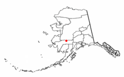
 Location of Red Devil, Alaska | |
| Coordinates: 61°46′41″N 157°20′54″W | |
| Country | United States |
| State | Alaska |
| Census Area | Bethel |
| Government | |
| • State senator | Lyman Hoffman (D) |
| • State rep. | Bryce Edgmon (D) |
| Area | |
| • Total | 27.83 sq mi (72.07 km2) |
| • Land | 25.13 sq mi (65.08 km2) |
| • Water | 2.70 sq mi (6.99 km2) |
| Population (2020) | |
| • Total | 22 |
| • Density | 0.88/sq mi (0.34/km2) |
| Time zone | UTC-9 (Alaska (AKST)) |
| • Summer (DST) | UTC-8 (AKDT) |
| ZIP code | 99656 |
| Area code(s) | 907 |
| FIPS code | 02-64930 |
| GNIS ID | 2419198[2] |
History
The village was named after the Red Devil Mine, established in 1921 by Hans Halverson when numerous mercury (quicksilver) deposits were discovered in the surrounding Kilbuck-Kuskokwim Mountains. By 1933, the mine was producing substantial quantities of mercury. Although the mine changed ownership twice over the years, it continued to operate until 1971.[4]
Geography
According to the United States Census Bureau, the CDP has a total area of 26.4 square miles (68 km2), of which, 24.2 square miles (63 km2) of it is land and 2.2 square miles (5.7 km2) of it (8.34%) is water.[5]
Demographics
| Historical population | |||
|---|---|---|---|
| Census | Pop. | %± | |
| 1960 | 152 | — | |
| 1970 | 81 | −46.7% | |
| 1980 | 39 | −51.9% | |
| 1990 | 53 | 35.9% | |
| 2000 | 48 | −9.4% | |
| 2010 | 23 | −52.1% | |
| 2020 | 22 | −4.3% | |
| U.S. Decennial Census[6] | |||
Red Devil first appeared on the 1960 U.S. Census as an unincorporated village. In 1980, it was made a census-designated place (CDP).
As of the census [7] of 2010, there were 23 people, 12 occupied households, residing in the CDP. The population density was 1.9 people per square mile (0.8/km2). There were 22 housing units at an average density of 0.9/sq mi (0.4/km2). The racial makeup of the CDP was 17.4% White, 43.5% Native American, and 39.1% from two or more races. The population was spread out, with 2 people under the age of 14, 2 people 15 to 19 and the remaining 19 people were 25 or older. The median income for a household for 2009 in the CDP was $59,886. 40.4% of the population lives beneath the poverty line.
See also
References
- "2020 U.S. Gazetteer Files". United States Census Bureau. Retrieved October 29, 2021.
- U.S. Geological Survey Geographic Names Information System: Red Devil, Alaska
- http://webpmt.usps.gov/pmt003.cfm%5B%5D
- "Alaska Community Database Community Information Summaries (CIS)". Retrieved September 26, 2012.
- "Archived copy". Archived from the original on 2012-01-25. Retrieved 2012-06-24.
{{cite web}}: CS1 maint: archived copy as title (link) - "U.S. Decennial Census". Census.gov. Retrieved June 6, 2013.
- United States Census
External links
На других языках
- [en] Red Devil, Alaska
[ru] Ред-Девил (Аляска)
Ред-Девил (англ. Red Devil) — статистически обособленная местность в зоне переписи населения Бетел, штат Аляска, США. На 2010 год население местности составляло 23 человека.Другой контент может иметь иную лицензию. Перед использованием материалов сайта WikiSort.org внимательно изучите правила лицензирования конкретных элементов наполнения сайта.
WikiSort.org - проект по пересортировке и дополнению контента Википедии
