world.wikisort.org - USA
Nekoma is an unincorporated community in Rush County, Kansas, United States.[1] It lies along K-96 southwest of the city of La Crosse.[2]
Nekoma, Kansas | |
|---|---|
Unincorporated community | |
 KDOT map of Rush County (legend) | |
 Nekoma  Nekoma | |
| Coordinates: 38°28′25″N 99°26′31″W[1] | |
| Country | United States |
| State | Kansas |
| County | Rush |
| Elevation | 2,034 ft (620 m) |
| Time zone | UTC-6 (CST) |
| • Summer (DST) | UTC-5 (CDT) |
| ZIP code | 67559 |
| Area code | 785 |
| FIPS code | 20-49575 [1] |
| GNIS ID | 475606 [1] |
History
Nekoma was platted in 1884 by the railroad.[3] The first post office in Nekoma was established in 1890.[4]
It has a post office with the ZIP code 67559.[5]
Geography
Its elevation is 2,034 feet (621 m), and it is located at 38°28′25″N 99°26′31″W (38.4736250, -99.4420547).[6]
Education
The community is served by La Crosse USD 395 public school district.
References
- "Nekoma, Kansas", Geographic Names Information System, United States Geological Survey
- Rand McNally. The Road Atlas '08. Chicago: Rand McNally, 2008, p. 40.
- "History of Rush County". Rush County Economic Development. Archived from the original on March 22, 2012. Retrieved 22 June 2014.
- "Kansas Post Offices, 1828-1961". Kansas Historical Society. Archived from the original on October 9, 2013. Retrieved 22 June 2014.
- USPS – Cities by ZIP Code
- Geographic Names Information System Feature Detail Report, Geographic Names Information System, 1978-10-13. Accessed 2008-04-12.
Further reading
External links
- History of Cities in Rush County
- Rush County maps: Current, Historic, KDOT
Municipalities and communities of Rush County, Kansas, United States | ||
|---|---|---|
County seat: La Crosse | ||
| Cities | 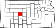 | |
| Unincorporated communities | ||
| Ghost towns | ||
| ||
Текст в блоке "Читать" взят с сайта "Википедия" и доступен по лицензии Creative Commons Attribution-ShareAlike; в отдельных случаях могут действовать дополнительные условия.
Другой контент может иметь иную лицензию. Перед использованием материалов сайта WikiSort.org внимательно изучите правила лицензирования конкретных элементов наполнения сайта.
Другой контент может иметь иную лицензию. Перед использованием материалов сайта WikiSort.org внимательно изучите правила лицензирования конкретных элементов наполнения сайта.
2019-2026
WikiSort.org - проект по пересортировке и дополнению контента Википедии
WikiSort.org - проект по пересортировке и дополнению контента Википедии