world.wikisort.org - USA
La Paz Valley is a census-designated place (CDP) in La Paz County, Arizona, United States. Its population was 368 as of the 2020 census. The community is in western La Paz County and is bordered to the north by the town of Quartzsite. To the south it is bordered by Yuma County.
La Paz Valley, Arizona | |
|---|---|
Census-designated place (CDP) | |
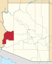
 Location of La Paz Valley in La Paz County, Arizona | |
 La Paz Valley  La Paz Valley | |
| Coordinates: 33°33′30″N 114°14′36″W | |
| Country | United States |
| State | Arizona |
| County | La Paz |
| Area | |
| • Total | 29.37 sq mi (76.06 km2) |
| • Land | 29.37 sq mi (76.06 km2) |
| • Water | 0.00 sq mi (0.00 km2) |
| Elevation | 1,027 ft (313 m) |
| Population (2020) | |
| • Total | 368 |
| • Density | 12.53/sq mi (4.84/km2) |
| Time zone | UTC-7 (Mountain (MST)) |
| Area code(s) | 928 |
| GNIS feature ID | 2582813 |
| FIPS code | 04-40160 |
U.S. Route 95 forms the eastern border of the CDP and runs north into Quartzsite and south 76 miles (122 km) to Yuma. The Town of Quartzsite operates demand response buses under the name Camel Express that provide weekday service to Quartzsite and La Paz Valley.[2]
Demographics
| Historical population | |||
|---|---|---|---|
| Census | Pop. | %± | |
| 2020 | 368 | — | |
| U.S. Decennial Census[3] | |||
References
- "2020 U.S. Gazetteer Files". United States Census Bureau. Retrieved October 29, 2021.
- "Public Transportation". Retrieved 2016-10-10.
- "Census of Population and Housing". Census.gov. Retrieved June 4, 2016.
External links
Текст в блоке "Читать" взят с сайта "Википедия" и доступен по лицензии Creative Commons Attribution-ShareAlike; в отдельных случаях могут действовать дополнительные условия.
Другой контент может иметь иную лицензию. Перед использованием материалов сайта WikiSort.org внимательно изучите правила лицензирования конкретных элементов наполнения сайта.
Другой контент может иметь иную лицензию. Перед использованием материалов сайта WikiSort.org внимательно изучите правила лицензирования конкретных элементов наполнения сайта.
2019-2025
WikiSort.org - проект по пересортировке и дополнению контента Википедии
WikiSort.org - проект по пересортировке и дополнению контента Википедии
