world.wikisort.org - USA
Emerson/Garfield is a neighborhood in Spokane, Washington. It is located immediately north of Downtown Spokane's North Bank and extends out into the inner northwestern portion of the city. Emerson/Garfield is a diverse neighborhood with residential, commercial and civic zones all bordering one another, with density ranging from single-family homes to multi-use buildings. Due to its location in the central area of Spokane, Emerson/Garfield is criss-crossed by numerous arterials and thoroughfares. Along those main roads are numerous commercial and retail districts of importance to both the neighborhood and city as a whole.
Emerson/Garfield | |
|---|---|
Spokane Neighborhood | |
 Monroe Street looking south over Emerson/Garfield towards Downtown Spokane | |
| Coordinates: 47°40′57.7″N 117°25′25.1″W | |
| Country | United States |
| State | Washington |
| County | Spokane |
| City | Spokane |
| Population (2017 [1]) | |
| • Total | 9,690 |
| Demographics 2017 | |
| • White | 83.3% |
| • Latinx | 7.7% |
| • American Indian | 3.1% |
| • Asian/Native Hawaiian/Pacific Islander | 2.5% |
| • Black | 2.5% |
| Time zone | UTC-8 (PST) |
| • Summer (DST) | UTC-7 (PDT) |
| ZIP Codes | 99201, 99205 |
| Area code(s) | 509 |
History
The area that is now Emerson/Garfield was inhabited since prehistoric times by the Spokane.[2]
Emerson/Garfield was one of the first areas settled by Europeans in the Spokane area after the city was founded, and Corbin Park became the site of fairs from 1887. In 1899, Corbin Park would take on its name when D.C. Corbin, a railroad and mining magnate, purchased and platted the area. Corbin established the park, and Queen Anne, bungalow and classic box-style homes were built around it. The residential areas of the neighborhood were mostly built out by the early 1900s. In 1913, the Olmstead Brothers updated the park as part of their master plan design for the city.[3]
Geography
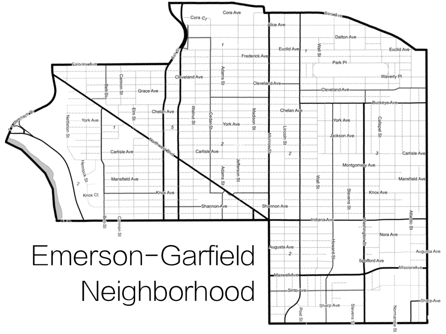
Emerson/Garfield is located immediately north of Downtown Spokane and south of the North Hill bluff. Division Street is the neighborhood's eastern border, and the city's main north–south thoroughfare. Division Street also carries U.S. Route 2 and U.S. Route 395. It is a major commercial district as well.[4] The northern boundary mostly follows a natural rise in elevation along Cora Avenue.[4][5] The T.J. Meenach Bridge over the Spokane River marks the westernmost point of the neighborhood. Indiana Avenue serves as the southern border for the western two-thirds until Monroe Street, where the boundary moves south to Boone Avenue.[5]
Topographically, the neighborhood is mostly flat and lies on a plain near the Spokane River at the westernmost edge of the Spokane Valley. Elevations in Emerson/Garfield tend to rise gradually to the north and to the east, away from the river. Emerson/Garfield sits at approximately 1,900 feet above sea level, but the surrounding terrain rises rapidly at the north, at North Hill, and falls off quickly at the west, to the Spokane River.[4]
Districts
North Central
North Central is so named for being located directly north of the central business district of Spokane, though it is the most southerly portion of the Emerson/Garfield neighborhood.[4] It is also the area surrounding North Central High School. It is bounded by Indiana Avenue on the north, Division Street on the east, Boone Avenue on the south and Monroe Street on the west. North Central's built environment is a blend of the denser downtown core to the south and the rest of the city to the north. Residential and commercial zones of mixed densities border each other across North Central, with single family homes across the street from multi-story office complexes and mid-density apartments alongside commercial centers.
Corbin Park
Surrounding the public park which gives this area its name is the Corbin Park Historic District. Corbin Park is a four block long by one block wide, oval of a park that was originally home to Spokane's first fairgrounds. The oval shape is a remnant of the track that once surrounded the park. It is now surrounded by homes built between 1900 and 1925 in the Queen Anne, Tudor Revival, American Foursquare, Arts & Crafts, and Bungalow styles. The design of the park was made by the Olmstead Brothers in 1909.[6]
The Corbin Park area is located in the northwestern corner of Emerson/Garfield. Division Street runs along a ridge above and to the east, while the North Hill ridge rises to the north behind Cora Avenue. Post Street on the west and Buckeye Avenue on the north mark the other bounds. The historic district itself is much smaller, and contained to only the streets immediately surrounding Corbin Park. It includes all properties from Post Street on the west to Normandie Street on the east, which front Park Place, Waverly Place, West Oval and East Oval.[7]
North Monroe
Monroe Street is a major north–south thoroughfare in Spokane. It connects Emerson/Garfield with points to the north in the city with Downtown Spokane via the Monroe Street Bridge. It is also a commercial and retail district as it passes through the neighborhood. In 2018, major work was completed turning Monroe Street from a five-lane road into a three-lane road, with enhanced pedestrian and public transit resources.[8] The North Monroe Corridor spills south into the Riverside and West Central neighborhoods, and is home to numerous businesses, shops, restaurants and other commercial ventures.[9]
Audubon
Audubon/Downriver is an official neighborhood bordering Emerson/Garfield to the northwest, but the broader Audubon area extends into the northwesternmost corner of Emerson/Garfield. Audubon Elementary, a public school, is located on Carlisle Avenue in Emerson/Garfield, with its campus extending to Northwest Boulevard.[10] There is a commercial and retail business district along Northwest Boulevard here that stretches into the Audubon/Downriver Neighborhood proper.[4][5][3]
Demographics
As of 2017, Emerson/Garfield was home to 9,690 people across 4,156 households. 15.1% of the population was above the age of 65 while 23.9% was aged 19 or younger. Persons of color made up 4.3% of the population, compared to 15.1% citywide. The median household income was $38,108, compared to $44,678 citywide. 51.5% of households were rented, compared to 45.3% citywide. The unemployment rate was 9%, above the citywide rate of 6.57%. 95.7% of residents were born in the United States or its territories, but of those who were not 19.6% came from Ukraine, 9.9% from Canada, 7.1% from Germany and 6.6% from South Korea.[1]
Transportation
Highway
![]() - U.S. 2 - to Newport, Washington (east) and Interstate 90 (west).
- U.S. 2 - to Newport, Washington (east) and Interstate 90 (west).
![]() - U.S 395 - to Colville, Washington (north) and Interstate 90 (south).
- U.S 395 - to Colville, Washington (north) and Interstate 90 (south).
City Streets
Located centrally within the city, Emerson/Garfield is well connected to the rest of the city street grid. Many streets through the neighborhood are considered urban principal arterials, the highest level of classification in the city. They are, from east to west, Division Street, Washington Street (to Buckeye Avenue), Monroe Street, Northwest Boulevard, the Maple/Ash Street couplet and T.J. Meenach Drive. Mission/Maxwell Avenue is the only east-west urban principal arterial in the neighborhood, though east-west streets Buckeye Avenue, Indiana Avenue and Boone Avenue are considered as urban minor arterials.[11]
Dedicated bike lanes going north-south are located along Bernard Street and Lincoln Street, and going east-west on Maxwell Avenue and Buckeye Avenue. There is a shared-use path along Pettet Drive on the western edge of Emerson/Garfield.[12]
Public Transit
Emerson/Garfield is served by the Spokane Transit Authority, the region's public transit provider. Frequent service is provided by Route 25 along Division Street, Route 4 along Monroe Street, and Route 33 along T.J. Meenach Drive. Route 25 connects to Downtown in the south and the Hastings Park and Ride in suburban Fairwood in the north. Route 4 connects to Downtown in the south and the Five Mile Park and Ride in the Balboa/South Indian Trail neighborhood in the north. Route 33 makes an arcing path across the north side of the city connecting Spokane Falls Community College on the west with Spokane Community College on the east.[13]
Additionally, there are four basic frequency routes serving Emerson/Garfield. Route 22 connects Downtown on the south with the Five Mile Park and Ride via Boone Avenue, the Maple/Ash Street couplet and Northwest Boulevard. Route 23 connects Downtown with the North Indian Trail neighborhood via Boone Avenue and the Maple/Ash Street couplet. Route 27 connects Downtown with Northeast Spokane via Washington Street and Indiana Avenue. Route 39 connects Downtown with Spokane Community College via Washington Street and Mission Avenue.[13]
Route 124 is an express route connecting Downtown with park and ride centers in Fairwood, via Monroe Avenue, but it makes its last outbound stop four blocks south of Emerson/Garfield's southern border.[13]
References
- "Emerson/Garfield Neighborhood Snapshot" (PDF). spokanecity.org. City of Spokane. Retrieved 21 May 2022.
- "HISTORY - Spokane Tribe of Indians". spokanetribe.com. Spokane Tribe of Indians. Retrieved 21 May 2022.
- "Emerson/Garfield Neighborhood Profile" (PDF). spokanecity.org. City of Spokane. Retrieved 21 May 2022.
- "Spokane NW Quadrangle" (7.5 minute quadrangle topographical map). usgs.gov. U.S. Geological Survey. Retrieved 21 May 2022.
- "Emerson/Garfield Neighborhood Map". emersongarfield.org. Retrieved 21 May 2022.
- "Historic Spokane". historicspokane.org. City - County of Spokane Historic Preservation Office. Retrieved 21 May 2022.
- "Corbin Park Historic District" (PDF). historicspokane.org. City - County of Spokane Historic Preservation Office. Retrieved 21 May 2022.
- "North Monroe Corridor". spokanecity.org. City of Spokane.
- "North Monroe Business District". meetonmonroe.com. North Monroe Business District. Retrieved 21 May 2022.
- "Audubon Elementary". spokaneschools.org. Spokane Public Schools. Retrieved 21 May 2022.
- "City of Spokane Official Arterial Street Map" (PDF). spokanecity.org. City of Spokane. Retrieved 22 May 2022.
- "Spokane Regional Bike Map". srtc.maps.arcgis.com. Spokane Regional Transportation Council. Retrieved 22 May 2022.
- "STA System Map" (PDF). spokanetransit.com. Spokane Transit Authority. Retrieved 22 May 2022.
Places adjacent to Emerson/Garfield, Spokane | ||||||||||||||||
|---|---|---|---|---|---|---|---|---|---|---|---|---|---|---|---|---|
| ||||||||||||||||
Другой контент может иметь иную лицензию. Перед использованием материалов сайта WikiSort.org внимательно изучите правила лицензирования конкретных элементов наполнения сайта.
WikiSort.org - проект по пересортировке и дополнению контента Википедии