world.wikisort.org - Vereinigte_Staaten
Ashland ist eine Ortschaft (Census-designated place) im Rosebud County im US-Bundesstaat Montana, Vereinigte Staaten.
| Ashland | |
|---|---|
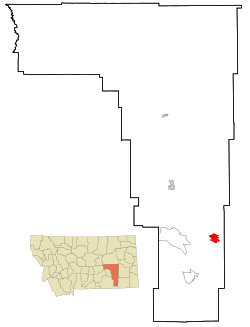 Lage in Montana | |
| Basisdaten | |
| Staat: | Vereinigte Staaten |
| Bundesstaat: | Montana |
| County: | Rosebud County |
| Koordinaten: | 45° 36′ N, 106° 17′ W |
| Zeitzone: | Mountain (UTC−7/−6) |
| Einwohner: | 773 (Stand: 2020) |
| Haushalte: | 354 (Stand: 2020) |
| Fläche: | 19,6 km² (ca. 8 mi²) |
| Bevölkerungsdichte: | 39 Einwohner je km² |
| Höhe: | 890 m |
| Postleitzahlen: | 59003 - 59004 |
| Vorwahl: | +1 406 |
| FIPS: | 30-02800 |
| GNIS-ID: | 0802003 |
Der Ort liegt direkt östlich des Northern Cheyenne Indian Reservation der Nördliche Cheyenne im Custer National Forest.
Der indianische Name lautet Vóhkoohémâhoéve'ho'éno.
На других языках
- [de] Ashland (Montana)
[en] Ashland, Montana
Ashland is a census-designated place (CDP) in Rosebud County, Montana, United States. The population was 464 at the 2000 census. Ashland is immediately east of the boundary of the Northern Cheyenne Indian Reservation and also along the Tongue River. It is the location of the St. Labre Indian Catholic High School, established in 1884 as a boarding school by a Catholic mission to the Cheyenne.[1]Текст в блоке "Читать" взят с сайта "Википедия" и доступен по лицензии Creative Commons Attribution-ShareAlike; в отдельных случаях могут действовать дополнительные условия.
Другой контент может иметь иную лицензию. Перед использованием материалов сайта WikiSort.org внимательно изучите правила лицензирования конкретных элементов наполнения сайта.
Другой контент может иметь иную лицензию. Перед использованием материалов сайта WikiSort.org внимательно изучите правила лицензирования конкретных элементов наполнения сайта.
2019-2025
WikiSort.org - проект по пересортировке и дополнению контента Википедии
WikiSort.org - проект по пересортировке и дополнению контента Википедии