world.wikisort.org - Regno_Unito
Skarfskerry (o Scarfskerry; in lingua gaelica scozzese: Sgarbh Sgeir) è l'insediamento abitato più a nord della Scozia e dell'intera Gran Bretagna, non considerando le isole. Si trova nella regione di Caithness, su una piccola penisola a nord-est di Thurso, poco fuori dalla strada A836. Il nome proviene dall'antico norreno e significa "roccia dei cormorani".[1] Storicamente, apparteneva alla Parrocchia di Dunnet, insieme a Brough.[2]
| Skarfskerry località | |
|---|---|
| Sgarbh Sgeir | |
 | |
| Localizzazione | |
| Stato | |
| Area di consiglio | Highland |
| Territorio | |
| Coordinate | 58°38′24″N 3°15′36″W |
| Abitanti | 300 |
| Altre informazioni | |
| Cod. postale | KW14 |
| Prefisso | 01847 |
| Fuso orario | UTC+0 |
| Cartografia | |
 Skarfskerry | |
Geografia fisica
Il centro abitato rurale consiste di una serie di terreni recintati ed abitazioni, oltre a un piccolo porto con annesso molo, che però non viene più utilizzato per scopi commerciali, anche se operano alcune imbarcazioni che conducono i turisti a vedere i lagenorinchi rostrobianco, balenottere minori e focene.[3] Il molo, lungo circa 150 iarde, presenta una piccola ansa sul lato sud-occidentale,[4] e una piccola spiaggia rocciosa continua verso il vicino villaggio di Ham. Il villaggio contiene anche una piccola chiesa battista, ed è sede dell'Organizzazione Nazionale Scozzese della British Divers Marine Life Rescue.[5] Skarfskerry Point, una punta di terra biforcata, alta 30 piedi, segna il punto di ingresso orientale della Baia di Brough.[4] Il Loch of Mey si trova poco a sud-est del villaggio.
![Scarfskerry Pottery (spostata a John o' Groats nel 1986)[6]](//upload.wikimedia.org/wikipedia/commons/thumb/5/5d/Scarfskerry_Pottery_-_geograph.org.uk_-_253538.jpg/79px-Scarfskerry_Pottery_-_geograph.org.uk_-_253538.jpg) Scarfskerry Pottery (spostata a John o' Groats nel 1986)[6]
Scarfskerry Pottery (spostata a John o' Groats nel 1986)[6] Chiesa battista
 Fattorie presso Skarfskerry, Caithness
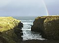 Panorami locali
![Scarfskerry Pottery (spostata a John o' Groats nel 1986)[6]](http://upload.wikimedia.org/wikipedia/commons/5/5d/Scarfskerry_Pottery_-_geograph.org.uk_-_253538.jpg)


Note
- Scarfskerry, su caithness.org. URL consultato il 1º marzo 2014.
- Topographical Dictionary of Scotland, Genealogical Publishing Com, p. 346, ISBN 978-0-8063-1255-2.
- Ben Wilson e Angus Wilson, The Complete Whale-Watching Handbook: A Guide to Whales, Dolphins, and Porpoises of the World, MBI Publishing Company, 2006, ISBN 978-0-7603-2567-4.
- Sailing directions for the north and east coasts of Scotland: Cape Wrath to Fife Ness and including the Orkney, Shetland and Faeroe Islands, United States Hydrographic Office, U.S. Govt. Print. Off., 1950, p. 80.
- Area Co-ordinators, su British Divers Marine Life Rescue. URL consultato il 9 ottobre 2014.
- Members Gallery - David Body, su Craft Potters' Association. URL consultato il 9 ottobre 2014 (archiviato dall'url originale il 17 ottobre 2014).
На других языках
[en] Skarfskerry
Skarfskerry (or Scarfskerry; Scottish Gaelic: Sgarbh Sgeir) is a settlement located in the far northern county Caithness on a small peninsula northeast of Thurso off the A836 in Scotland. It is the most northerly settlement in Great Britain. The name comes from the Old Norse for "cormorants' rock".[1] Historically, it belonged to the Parish of Dunnet, along with Brough.[2]- [it] Skarfskerry
Другой контент может иметь иную лицензию. Перед использованием материалов сайта WikiSort.org внимательно изучите правила лицензирования конкретных элементов наполнения сайта.
WikiSort.org - проект по пересортировке и дополнению контента Википедии