world.wikisort.org - Regno_Unito
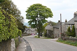
Sheldon è un villaggio e parrocchia civile dell'Inghilterra, appartenente alla contea del Derbyshire.
| Sheldon parrocchia civile | |
|---|---|
 | |
| Localizzazione | |
| Stato | |
| Regione | Midlands Orientali |
| Contea | |
| Distretto | Derbyshire Dales |
| Territorio | |
| Coordinate | 53°12′54″N 1°44′27.6″W |
| Abitanti | |
| Altre informazioni | |
| Cod. postale | DE45 |
| Fuso orario | UTC+0 |
| Cartografia | |
 | |
Altri progetti
 Wikimedia Commons contiene immagini o altri file su Sheldon (Derbyshire)
Collegamenti esterni
| Controllo di autorità | VIAF (EN) 22150202281703112391 · LCCN (EN) nb2017015704 |
|---|
На других языках
[en] Sheldon, Derbyshire
Sheldon is a village in the Derbyshire Peak District, England near Bakewell. It is best known for being the closest village to Magpie Mine, a lead mine with an engine house built in the Cornish style. Lead mining flourished around here in the 18th and 19th centuries. It is now scheduled as an ancient monument, and is the most complete example of a lead mine remaining in the Peak District. It is about 1050 feet above sea level. Sheldon is home of the Church of St Michael and All Angels as well. The church was erected in the 19th century with material derived from dismantling the former Chapel of Ease.- [it] Sheldon (Derbyshire)
Текст в блоке "Читать" взят с сайта "Википедия" и доступен по лицензии Creative Commons Attribution-ShareAlike; в отдельных случаях могут действовать дополнительные условия.
Другой контент может иметь иную лицензию. Перед использованием материалов сайта WikiSort.org внимательно изучите правила лицензирования конкретных элементов наполнения сайта.
Другой контент может иметь иную лицензию. Перед использованием материалов сайта WikiSort.org внимательно изучите правила лицензирования конкретных элементов наполнения сайта.
2019-2025
WikiSort.org - проект по пересортировке и дополнению контента Википедии
WikiSort.org - проект по пересортировке и дополнению контента Википедии
