world.wikisort.org - Regno_Unito
St Mawes (in lingua cornica: Lannvowsedh) è un villaggio della costa meridionale della Cornovaglia (Inghilterra sud-occidentale), situato nella penisola di Roseland e lungo le Carrick Roads e facente parte - dal punto di vista amministrativo - della parrocchia civile di St Just in Roseland[1] (distretto di Carrick).
| St Mawes villaggio | |
|---|---|
| Lannvowsedh | |
 | |
| Localizzazione | |
| Stato | |
| Regione | Sud Ovest |
| Contea | |
| Distretto | Carrick |
| Parrocchia civile | St Just in Roseland |
| Territorio | |
| Coordinate | 50°09.5′N 5°01′W |
| Abitanti | |
| Altre informazioni | |
| Cod. postale | TR2 |
| Fuso orario | UTC+0 |
| Cartografia | |
 St Mawes | |
| Sito istituzionale | |

Geografia fisica
Collocazione
Il villaggio di St Mawes si trova lungo la sponda orientale delle Carrick Roads, nel lato opposto della costa rispetto a Falmouth ed è situato ad ovest di Portscatho e Mevagissey e a sud di Truro.
Etimologia
Il toponimo S(ain)t Mawes deriva dal nome di un santo e patrono del villaggio, San Maudez, originario probabilmente dell'Irlanda.[2]
Storia
St Mawes divenne un borough nel 1562.[2]
Luoghi d'interesse
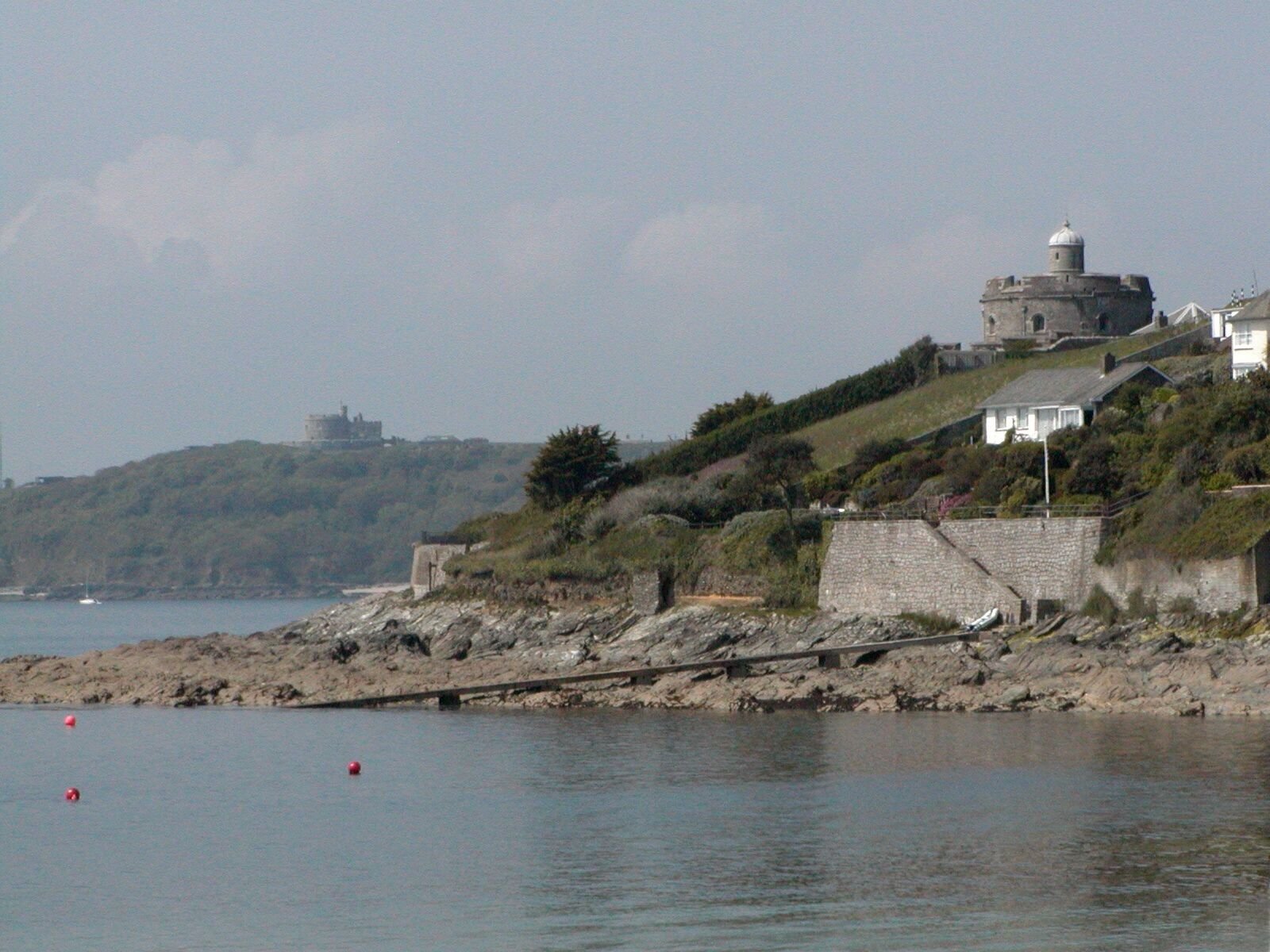
L'edificio più famoso di St Mawes è il castello, una fortezza fatta costruire da Enrico VIII tra il 1540 e il 1543 per respingere eventuali invasioni da parte dei Francesi e - come il dirimpettaio castello di Pendennis di Falmouth - espugnata dall'esercito repubblicano guidato da Oliver Cromwell nel 1645.[3]
Un altro edificio d'interesse è il Faro di Sant'Antonio, risalente al 1834.[4]
St Mawes nel cinema e nelle fiction
- Furono girate a St Mawes alcune scene del film Assassinio a bordo (Murder Ahoy, 1964), tratto da un romanzo di Agatha Christie[5]
- St Mawes fu la principale location del film Un priore per Scotland Yard (Crooks in Cloisters) di Jeremy Summers (1964)[6]
- A St Mawes sono state girate alcune scene della serie televisiva britannica degli anni settanta, basata sulla serie di romanzi di Winston Graham, Poldark.[7]
- Cormoran Strike, protagonista della serie di romanzi polizieschi di Robert Galbraith, è originario di St. Mawes.
Galleria d'immagini


Note
- Genuki.org.uk: St-Just-in-Roseland Archiviato il 5 agosto 2011 in Internet Archive.
- Into Cornwall: St Mawes
- A.A.V.V., Gran Bretagna, Touring Club Italiano, 2003
- Cornwall Guide: St Mawes
- The Worldwide Guide to Movie Locations: M > Murder Ahoy, su movie-locations.com. URL consultato l'11 marzo 2011 (archiviato dall'url originale il 2 novembre 2016).
- IMDb: Un priore per Scotland Yard > Luoghi delle riprese
- IMDb: Poldark (1975) > Luoghi delle riprese
Altri progetti
 Wikimedia Commons contiene immagini o altri file su Saint Mawes
Collegamenti esterni
- St Mawes & Roseland, su stmawes.info.
- St Mawes & the Roseland, su stmawesandtheroseland.co.uk.
- Cornwall Guide: St Mawes, su cornwalls.co.uk.
- Into Cornwall: St Mawes, su intocornwall.com.
- St Mawes Harbour, su stmawesharbour.co.uk.
- English Heritage: St Mawes Castle, su english-heritage.org.uk.
| Controllo di autorità | VIAF (EN) 135007965 · LCCN (EN) n91091324 · WorldCat Identities (EN) lccn-n91091324 |
|---|
На других языках
[en] St Mawes
St Mawes (Cornish: Lannvowsedh) is a village on the end of the Roseland Peninsula, in the eastern side of Falmouth harbour, on the south coast of Cornwall, United Kingdom. The village, formerly two separate hamlets, lies on the east bank of the Carrick Roads, a large waterway created after the Ice Age from an ancient valley which flooded as the melt waters caused the sea level to rise. The immense natural harbour thus created is claimed to be the third largest in the world. St Mawes was once a busy fishing port, but the trade declined during the 20th century and the village now serves as a popular tourist location, with many properties functioning as holiday accommodation.[citation needed] The village is in the civil parish of St Just in Roseland.- [it] Saint Mawes
Другой контент может иметь иную лицензию. Перед использованием материалов сайта WikiSort.org внимательно изучите правила лицензирования конкретных элементов наполнения сайта.
WikiSort.org - проект по пересортировке и дополнению контента Википедии