world.wikisort.org - Regno_Unito
Portmahomack (in gaelico scozzese: Port Mo Chalmaig) è un villaggio di pescatori sul Mare del Nord della Scozia nord-orientale, affacciato sul Moray Firth e situato nella penisola di Tarbat[1] e facente parte - dal punto di vista amministrativo - della parrocchia civile di Tarbat, nell'area di Easter Ross (contea di Ross and Cromarty, nell'Highland).
| Portmahomack villaggio | |
|---|---|
| Port Mo Chalmaig | |
 | |
| Localizzazione | |
| Stato | |
| Area di consiglio | Highland |
| Territorio | |
| Coordinate | 57°50′13.02″N 3°49′38.86″W |
| Abitanti | |
| Altre informazioni | |
| Cod. postale | IV20 |
| Fuso orario | UTC+0 |
| Cartografia | |
 Portmahomack | |

Geografia fisica
Collocazione
Portmahomack si trova tra le località di Dornoch e Cromarty (rispettivamente a sud-est della prima e a nord-est della seconda)[2], a circa 65 km a nord-est di Inverness.
Storia
Il villaggio sorse grazie alla creazione di un priorato da parte di San Colmac.[1]
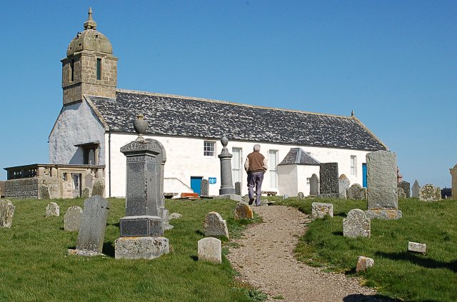
In loco fu poi costruita una chiesa nel 1255[1]. Questa chiesa fu rimpiazzata nel 1756 dall'Old Tarbat Parish Church[1].
Intorno agli anni trenta del XIX secolo la località conobbe il suo periodo più fiorente come villaggio di pescatori.[1]
Luoghi d'interesse
- Faro di Tarbat Ness
- Ballone Castle
Note
- Undiscovered Scotland: Portmahomack
- Guida Marco Polo - Scozia, Mairs Geographischer Verlag, Ostfildern - Hachette, Paris - De Agostini, Novara, 1999
Altri progetti
 Wikimedia Commons contiene immagini o altri file su Portmahomack
Collegamenti esterni
- Porthmahomack.net, su portmahomack.net.
- Portmahomack Community.org.uk, su portmahomackcommunity.org.uk.
- Portmahomack su Undiscovered Scotland
| Controllo di autorità | VIAF (EN) 234820633 |
|---|
На других языках
[en] Portmahomack
Portmahomack (Scottish Gaelic: Port Mo Chalmaig; 'Haven of My [i.e. 'Saint'] Colmóc') is a small fishing village in Easter Ross, Scotland. It is situated in the Tarbat Peninsula in the parish of Tarbat. Tarbat Ness Lighthouse is about three miles (five kilometres) from the village at the end of the Tarbat Peninsula. Ballone Castle lies about one mile (1.5 kilometres) from the village. There is evidence of early settlement, and the area seems to have been the site of significant activity during the time of the Picts, early Christianity and the Vikings. The village is situated on a sandy bay and has a small harbour designed by Thomas Telford: it shares with Hunstanton the unusual distinction of being on the east coast but facing west. Portmahomack lies inside the Moray Firth Special Area of Conservation [1] with the associated dolphin and whale watching activity.- [it] Portmahomack
Другой контент может иметь иную лицензию. Перед использованием материалов сайта WikiSort.org внимательно изучите правила лицензирования конкретных элементов наполнения сайта.
WikiSort.org - проект по пересортировке и дополнению контента Википедии