world.wikisort.org - Regno_Unito
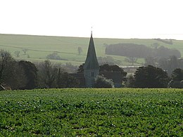
Patching è un piccolo villaggio e parrocchia civile di 259 abitanti. È situato fra i campi e boschi del sud del parco nazionale del South Downs nel distretto di Arun nella contea del West Sussex, in Inghilterra. È un insediamento abitato sorto prima del censimento del Domesday Book del 1086. È situato a 6,4 km a est di Arundel, a nord della strada A27. La parrocchia civile copre un'area di 846,12 ettari.
| Patching parrocchia civile | |
|---|---|
 | |
| Localizzazione | |
| Stato | |
| Regione | Sud Est |
| Contea | |
| Distretto | Arun (distretto) |
| Territorio | |
| Coordinate | 50°50′48.73″N 0°27′23.87″W |
| Superficie | 8,46[1] km² |
| Abitanti | 259[2] (2011) |
| Densità | 30,61 ab./km² |
| Altre informazioni | |
| Cod. postale | BN13 |
| Prefisso | 01903 |
| Fuso orario | UTC+0 |
| Cartografia | |
Nel centro del villaggio è situata la chiesa del XIII secolo di San Giovanni il Divino, restaurata nel 1888. Sopra il villaggio, nel South Downs, vi è un gruppo di mine di selce del neolitico, che è segnato da piccole cavità e tumuli.[3]
Michelgrove Park è nel nord della parrocchia e fu sito di una grande casa dove Sir William Shelley intrattenne Enrico VIII e che divenne casa dei baronetti di Shelley. È attraversato dal Monarch's Way, un lungo sentiero che segna il supposto percorso della fuga di Carlo II in Francia nel 1651.
Note
- 2001 Census: West Sussex – Population by Parish (PDF), su westsussex.gov.uk, West Sussex County Council. URL consultato il 3 aprile 2009 (archiviato dall'url originale l'8 giugno 2011).
- Key Statistics; Quick Statistics: Population Density Censimento del Regno Unito del 2011 Office for National Statistics, visitato il 10 maggio 2014.
- Ian Nairn e Pevsner, Nikolaus, The Buildings of England: Sussex, Harmondsworth, Penguin Books, 1965, pp. 222–3, ISBN 0-14-071028-0.
Altri progetti
 Wikimedia Commons contiene immagini o altri file su Patching
Collegamenti esterni
- Clapham and Patching villages website[collegamento interrotto]
На других языках
[en] Patching
Patching is a small village and civil parish that lies amid the fields and woods of the southern slopes of the South Downs in the National Park in the Arun District of West Sussex, England. It has a visible hill-workings history going back to before the Domesday survey of 1086–7. It is centred four miles (6.4 km) to the east of Arundel and quarter of a mile from Clapham, to the north of the A27 road. The civil parish covers an area of 846.12 hectares (2,090.8 acres).- [it] Patching
Другой контент может иметь иную лицензию. Перед использованием материалов сайта WikiSort.org внимательно изучите правила лицензирования конкретных элементов наполнения сайта.
WikiSort.org - проект по пересортировке и дополнению контента Википедии
