world.wikisort.org - Regno_Unito
Il Nord Est (North East in inglese) è una delle regioni dell'Inghilterra. La regione è anche conosciuta come Northumbria. Confina con le regioni Yorkshire e Humber a sud e Nord Ovest a ovest, con la Scozia a nord e con il Mare del Nord a est.
| Nord Est dell'Inghilterra regione | |
|---|---|
| Localizzazione | |
| Stato | |
| Amministrazione | |
| Capoluogo | Newcastle upon Tyne |
| Data di istituzione | 1994 |
| Territorio | |
| Coordinate del capoluogo | 54°58′40.8″N 1°37′04.8″W |
| Superficie | 8 573,17 km² |
| Abitanti | 2 657 909[1] (2018) |
| Densità | 310,03 ab./km² |
| Altre informazioni | |
| Fuso orario | UTC+0 |
| Codice ONS | E12000001 |
| PIL procapite | (nominale) 13 275 £ |
| Cartografia | |
 | |
Aspetti politici
Il 4 novembre 2004 si è tenuto un referendum nella regione, che ha rigettato la proposta di creazione di un'assemblea regionale democraticamente eletta. Di conseguenza, nel 2008 anche l'esistente assemblea interprovinciale nominata dalle contee è stata abolita. Anche un coordinamento di amministratori locali, inaugurato nel 2011, si è sciolto nel 2016.
Esiste un partito politico locale, che si ispira alle ideologie di un regionalismo dell'autonomia della regione stessa.
Suddivisioni
| Mappa | Contea cerimoniale | Contea / autorità unitaria | Distretti |
|---|---|---|---|
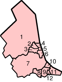 | 1. Northumberland † | Blyth Valley Wansbeck Castle Morpeth Tynedale Alnwick Berwick-upon-Tweed | |
| Tyne and Wear * | 2. Newcastle upon Tyne 3. Gateshead 4. North Tyneside 5. South Tyneside 6. Sunderland | ||
| County Durham | 7. County Durham † | City of Durham Easington Sedgefield Teesdale Wear Valley Derwentside Chester-le-Street | |
| 8. Darlington | |||
| 9. Hartlepool | |||
| 10. Stockton-on-Tees a nord del fiume Tees | |||
| North Yorkshire (parte) | 10. Stockton-on-Tees a sud del fiume Tees | ||
| 11. Redcar and Cleveland | |||
| 12. Middlesbrough | |||
Legenda: contea non metropolitana = † | contea metropolitana = *
La regione fu originariamente definita come Northumberland, Tyne and Wear, Contea di Durham e Cleveland. Da allora, la contea di Tyne and Wear è stata abolita, Darlington si è staccato dalla Contea di Durham e il Cleveland è stato diviso in quattro parti.
La regione è ora considerata come costituita da quattro sub-regioni distinte: la Contea di Durham, il Northumberland, Tyne & Wear e la Tees Valley (l'ex Cleveland più Darlington)
Note
Altri progetti
 Wikimedia Commons contiene immagini o altri file su Nord Est
 Wikivoyage contiene informazioni turistiche su Nord Est
Collegamenti esterni
- North East Regional Assembly, su northeastassembly.gov.uk. URL consultato il 22 settembre 2007 (archiviato dall'url originale il 20 marzo 2008).
- One NorthEast - Regional Development Agency, su onenortheast.co.uk. URL consultato il 2 marzo 2005 (archiviato dall'url originale il 9 maggio 2008).
| Controllo di autorità | VIAF (EN) 315134656 |
|---|
На других языках
[en] North East England
North East England is one of nine official regions of England at the first level of ITL for statistical purposes.[lower-alpha 1] The region has three current administrative levels below the region level in the region; combined authority, unitary authority or metropolitan district and civil parishes. They are also multiple divisions without administrative functions; ceremonial county, emergency services (fire-and-rescue and police), built-up areas and historic county. The most populous places in the region are Newcastle upon Tyne (city), Middlesbrough, Sunderland (city), Gateshead, Darlington and Hartlepool. Durham is also a city, it has a small population.- [it] Nord Est (Inghilterra)
[ru] Северо-Восточная Англия
Се́веро-Восто́чная А́нглия (англ. North East England) — регион на севере Англии. Включает четыре церемониальных графства, а также несколько унитарных и муниципальных районов. Административный центр — Ньюкасл-апон-Тайн.Другой контент может иметь иную лицензию. Перед использованием материалов сайта WikiSort.org внимательно изучите правила лицензирования конкретных элементов наполнения сайта.
WikiSort.org - проект по пересортировке и дополнению контента Википедии