world.wikisort.org - Regno_Unito
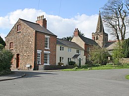
Markfield è un villaggio e parrocchia civile dell'Inghilterra, appartenente alla contea del Leicestershire.
| Markfield parrocchia civile | |
|---|---|
 | |
| Localizzazione | |
| Stato | |
| Regione | Midlands Orientali |
| Contea | |
| Distretto | Hinckley and Bosworth |
| Territorio | |
| Coordinate | 52°41′16.09″N 1°16′39.04″W |
| Abitanti | 5 681 (2011) |
| Altre informazioni | |
| Prefisso | 01530 |
| Fuso orario | UTC+0 |
| Cartografia | |
Altri progetti
 Wikimedia Commons contiene immagini o altri file su Markfield
Collegamenti esterni
- (EN) Sito web istituzionale del Leicestershire, su leicestershire.gov.uk.
| Controllo di autorità | VIAF (EN) 125134533 |
|---|
На других языках
[en] Markfield
Markfield is a large village in both the National Forest and Charnwood Forest and in the Hinckley and Bosworth district of Leicestershire, England. The settlement dates back to at least the time of the Norman conquest and is mentioned in the Domesday Book under the name Merchenefeld. A variant of this is still used as the name for the village primary school, Mercenfeld. It is to the south-east of Junction 22 of the M1, and to the south of the A50. The highest point in Markfield is shown on OS sheet 129 at 222 metres above sea level. Nearby places are Newtown Linford, Groby, Field Head, and Stanton under Bardon. In the 1841 census its population was recorded at 1,203.[2] In the 2011 census the parish had a population of 5681.[1] Markfield is within the LE67 postcode district. In 2012 Hinckley & Bosworth Borough Council published an overview of Markfield conservation area.[3]- [it] Markfield
Текст в блоке "Читать" взят с сайта "Википедия" и доступен по лицензии Creative Commons Attribution-ShareAlike; в отдельных случаях могут действовать дополнительные условия.
Другой контент может иметь иную лицензию. Перед использованием материалов сайта WikiSort.org внимательно изучите правила лицензирования конкретных элементов наполнения сайта.
Другой контент может иметь иную лицензию. Перед использованием материалов сайта WikiSort.org внимательно изучите правила лицензирования конкретных элементов наполнения сайта.
2019-2025
WikiSort.org - проект по пересортировке и дополнению контента Википедии
WikiSort.org - проект по пересортировке и дополнению контента Википедии
