world.wikisort.org - Regno_Unito
Hawarden è un centro abitato del Galles, situato nella contea del Flintshire.
| Hawarden community | |
|---|---|
 | |
| Localizzazione | |
| Stato | |
| Area principale | Flintshire |
| Territorio | |
| Coordinate | 53°10′55.2″N 3°01′12″W |
| Abitanti | 1 887 (2011) |
| Altre informazioni | |
| Cod. postale | CH5 |
| Fuso orario | UTC+0 |
| Cartografia | |
 Hawarden | |
Altri progetti
 Wikimedia Commons contiene immagini o altri file su Hawarden (Flintshire)
Collegamenti esterni
- (EN) Hawarden (Flintshire), su Enciclopedia Britannica, Encyclopædia Britannica, Inc.
| Controllo di autorità | VIAF (EN) 154071282 · LCCN (EN) nr2002027578 · WorldCat Identities (EN) lccn-nr2002027578 |
|---|
На других языках
[en] Hawarden
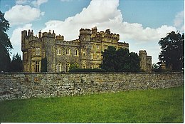
Hawarden (/ˈhɑːrdən/ (listen); Welsh: Penarlâg) is a village, community and electoral ward, in Flintshire, Wales. It is part of the Deeside conurbation on the Wales-England border and is home to Hawarden Castle. In the 2011 census the ward of the same name had a population of 1,887,[1] whereas the community of the same name, which also includes Ewloe (which also has a castle) Mancot and Aston had a population of 13,920.[2] The scenic wooded Hawarden Park abuts the clustered settlement in the south. Hawarden Bridge consists of distribution and industrial business premises beyond Shotton/Queensferry and the Dee.[3] The west of the main street is called The Highway, its start marked by the crossroads with a fountain in the middle, near which are public houses, some with restaurants.[n 1]- [it] Hawarden (Flintshire)
Текст в блоке "Читать" взят с сайта "Википедия" и доступен по лицензии Creative Commons Attribution-ShareAlike; в отдельных случаях могут действовать дополнительные условия.
Другой контент может иметь иную лицензию. Перед использованием материалов сайта WikiSort.org внимательно изучите правила лицензирования конкретных элементов наполнения сайта.
Другой контент может иметь иную лицензию. Перед использованием материалов сайта WikiSort.org внимательно изучите правила лицензирования конкретных элементов наполнения сайта.
2019-2025
WikiSort.org - проект по пересортировке и дополнению контента Википедии
WikiSort.org - проект по пересортировке и дополнению контента Википедии