world.wikisort.org - Regno_Unito
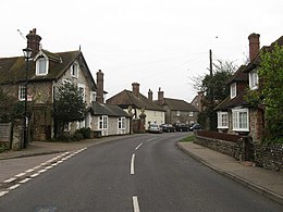
Angemering è un villaggio posto a circa 6 km da Littlehampton e Worthing nella contea del West Sussex. Si trova vicino al mare, infatti il Canale della Manica dista solo 3 km.
| Angmering parrocchia civile | |
|---|---|
 | |
| Localizzazione | |
| Stato | |
| Regione | Sud Est |
| Contea | |
| Distretto | Arun (distretto) |
| Territorio | |
| Coordinate | 50°49′43.57″N 0°29′04.49″W |
| Superficie | 1 782 km² |
| Abitanti | 5 639 (2001) |
| Densità | 3,16 ab./km² |
| Altre informazioni | |
| Cod. postale | BN16 |
| Prefisso | 01903 |
| Fuso orario | UTC+0 |
| Cartografia | |
| Sito istituzionale | |
Panoramica
La parrocchia civile si estende per circa 10 km di lunghezza e 3 di larghezza, le origini del villaggio sono remote e risalgono all'Età del bronzo, nella zona si trovano anche i resti di una villa romana. Ad Angmering si trova una chiesa del XII secolo, intitolata a St. Mary, che è stata ampiamente ristrutturata nel 1852 da Samuel Senders Teulon (2 marzo 1812-2 maggio 1873) e di nuovo nel 2009. Poco distante dal villaggio si trova Highdown Hill una collina che porta resti risalenti all'Età del bronzo e in cui oggi si trovano dei vigneti racchiusi entro gli Highdown Gardens ricavati da un'antica cava di gesso. Tutta questa zona è sotto la protezione del National Trust for Places of Historic Interest or Natural Beauty. Ad Angmering nacque Tom Olliver (1812-7 gennaio 1874), un fantino ed allenatore di cavalli da corsa che vinse il Grand National nel 1842, 1843 e 1852.
Etimologia
Il nome del villaggio deriva dal sassone e significa "i seguaci o i dipendenti di Angenmaer"[1].
Gemellaggio
Angmering è gemellato con Ouistreham nella regione del Calvados in Francia.
- Ouistreham
 Francia
Note
- Hunter Blair, Peter (1966). Roman Britain and Early England: 55 B.C. - A.D. 871. W.W. Norton & Company. pp. 176
Altri progetti
 Wikimedia Commons contiene immagini o altri file su Angmering
Collegamenti esterni
- (EN) sito del comune, su angmeringparishcouncil.gov.uk. URL consultato il 2 agosto 2011 (archiviato dall'url originale il 26 agosto 2011).
На других языках
[en] Angmering
Angmering is a village and civil parish between Littlehampton and Worthing in West Sussex on the southern edge of the South Downs National Park, England; about two-thirds of the parish (mostly north of the A27 road) fall within the Park. It is 1.5 miles (2.4 km) north of the English Channel; Worthing and Littlehampton are 3.5 miles (5.6 km) to the east and west respectively. It has been inhabited since the Bronze Age and there are the remains of a Roman Villa and bath house. In 1976, Angmering was twinned with the Normandy town of Ouistreham on the "Riva-Bella", the location of the World War II Normandy Landings' Sword Beach.[3]- [it] Angmering
Другой контент может иметь иную лицензию. Перед использованием материалов сайта WikiSort.org внимательно изучите правила лицензирования конкретных элементов наполнения сайта.
WikiSort.org - проект по пересортировке и дополнению контента Википедии
