world.wikisort.org - Royaume-Uni
Ramsbottom est un village du Royaume-Uni, situé au nord des villes de Bury et Manchester, dans le Grand Manchester en Angleterre.
Cet article est une ébauche concernant Manchester ou le Grand Manchester.
Vous pouvez partager vos connaissances en l’améliorant (comment ?) selon les recommandations des projets correspondants.
| Ramsbottom | |||
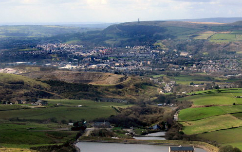 Vue générale | |||
| Administration | |||
|---|---|---|---|
| Pays | |||
| Nation | |||
| Comté | Grand Manchester | ||
| Force de police | Greater Manchester | ||
| Incendie | Greater Manchester | ||
| Ambulance | North West | ||
| Code postal | BL0 | ||
| Indicatif | 01706 | ||
| Démographie | |||
| Population | 17 352 hab. (2001) | ||
| Géographie | |||
| Coordonnées | 53° 38′ 54″ nord, 2° 19′ 01″ ouest | ||
| Localisation | |||
| Géolocalisation sur la carte : Royaume-Uni
Géolocalisation sur la carte : Royaume-Uni
| |||
| modifier |
|||


La population totale de Ramsbottom est d'environ 17 352 habitants. Le village est plutôt sous gouverne de la ville de Bury, le député de Ramsbotton étant d'ailleurs David Chaytor, MP du nord de Bury.
Ramsbottom est connu pour sa tour, the Peel Monument, haute de 39 mètres, située près du village sur la colline de Holcolme et nommée d'après le premier ministre Robert Peel (1788-1850).
 Portail de l’Angleterre
На других языках
[en] Ramsbottom
Ramsbottom is a market town in the Metropolitan Borough of Bury, Greater Manchester, England.[1] The population at the 2011 census was 17,872.[2]- [fr] Ramsbottom
Текст в блоке "Читать" взят с сайта "Википедия" и доступен по лицензии Creative Commons Attribution-ShareAlike; в отдельных случаях могут действовать дополнительные условия.
Другой контент может иметь иную лицензию. Перед использованием материалов сайта WikiSort.org внимательно изучите правила лицензирования конкретных элементов наполнения сайта.
Другой контент может иметь иную лицензию. Перед использованием материалов сайта WikiSort.org внимательно изучите правила лицензирования конкретных элементов наполнения сайта.
2019-2026
WikiSort.org - проект по пересортировке и дополнению контента Википедии
WikiSort.org - проект по пересортировке и дополнению контента Википедии