world.wikisort.org - Royaume-Uni
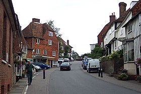
Goudhurst est un charmant village du kentish weald Royaume-Uni, situé dans le comté de Kent en Angleterre. Sa population était de 3 327 habitants en 2011. À proximité se trouve le magnifique manoir (hanté) de Twyssenden .
Personnalités liées
- Sheila Noakes, faite baronne de la ville en 2000.
Notes et références
- Portail de l’Angleterre
На других языках
[en] Goudhurst
Goudhurst is a village and civil parish in the borough of Tunbridge Wells in Kent, England. It lies in the Weald, around 12 miles (19 km) south of Maidstone, on the crossroads of the A262 and B2079.- [fr] Goudhurst
Текст в блоке "Читать" взят с сайта "Википедия" и доступен по лицензии Creative Commons Attribution-ShareAlike; в отдельных случаях могут действовать дополнительные условия.
Другой контент может иметь иную лицензию. Перед использованием материалов сайта WikiSort.org внимательно изучите правила лицензирования конкретных элементов наполнения сайта.
Другой контент может иметь иную лицензию. Перед использованием материалов сайта WikiSort.org внимательно изучите правила лицензирования конкретных элементов наполнения сайта.
2019-2025
WikiSort.org - проект по пересортировке и дополнению контента Википедии
WikiSort.org - проект по пересортировке и дополнению контента Википедии


