world.wikisort.org - Royaume-Uni
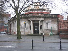
Chorlton-cum-Hardy (ou Chorlton) est un quartier au sud de la ville de Manchester, au nord-ouest de l'Angleterre.
Ne doit pas être confondu avec Chorlton-on-Medlock.
Chorlton se trouve environ à 6 km sud-ouest du centre de la ville. La population de Chorlton en 2001 était 13 512 habitants.
Historiquement, Chorlton était un village agricole du Lancashire dans la vallée de la Mersey, petit fleuve ayant son embouchure à Liverpool ; il a été intégré à Manchester en 1904. Les quartiers voisins sont Stretford à l'ouest, Sale au sud, Didsbury et Withington à l'est, Whalley Range et Old Trafford au nord.
Références
- Portail de Manchester et son comté
На других языках
[en] Chorlton-cum-Hardy
Chorlton-cum-Hardy is a suburban area of Manchester, England, three miles (4.8 km) southwest of the city centre. Chorlton ward had a population of 14,138 at the 2011 census,[1] and Chorlton Park 15,147.[2]- [fr] Chorlton-cum-Hardy
Текст в блоке "Читать" взят с сайта "Википедия" и доступен по лицензии Creative Commons Attribution-ShareAlike; в отдельных случаях могут действовать дополнительные условия.
Другой контент может иметь иную лицензию. Перед использованием материалов сайта WikiSort.org внимательно изучите правила лицензирования конкретных элементов наполнения сайта.
Другой контент может иметь иную лицензию. Перед использованием материалов сайта WikiSort.org внимательно изучите правила лицензирования конкретных элементов наполнения сайта.
2019-2025
WikiSort.org - проект по пересортировке и дополнению контента Википедии
WikiSort.org - проект по пересортировке и дополнению контента Википедии


